We have compiled frequently asked questions and answers for you here. It’s worth taking a look, as we are constantly adding to this section. If you can’t find what you are looking for, please contact us.
New
The Environmental Atlas maps are available in the new Map Application
FAQ
-
How long has the Berlin Environmental Atlas been around?
The Environmental Atlas dates back to concepts and projects from the beginning of the 1980s, the early days of digital data processing.
The first modern Berlin Nature Conservation Law (Berliner Naturschutzgesetz) came into force in West Berlin at the end of the 1970s. This document stipulated the legal requirement of drawing up the very first landscape programme for Berlin. The programme was to define development goals for nature and landscape then covering the western part of the city. In addition to the requirements of nature conservation, the programme was also to consider the aspects of recreation, the landscape’s visual impact and the ecosystem. Objectives, requirements and measures were to be presented in a separate programme plan.
Once work on the landscape programme commenced, it emerged that there was either not enough data available to serve as a comprehensive base or no data at all.
In order to address this problem and as there were no comparable projects in progress in Germany to be used as a model at the time, we launched the “Berlin Environmental Atlas” in 1983. It was a joint research project together with the German Environment Agency (UBA). This project was intended to rectify the lack of available planning bases systematically. It aimed at compiling maps and data for all topics included in the landscape programme, with special emphasis on the very complex topic of “ecosystem”, however. From the start, the idea was to publish all materials bilingually and uniformly, accessible both to planning authorities and the public. From day one, a key endeavour of the project was to keep the public informed about the state of the environment. In 1985, the first volume of the Environmental Atlas was published – still on paper from cover to cover.
This was followed by another research project with a stronger planning approach that was supported by the growing number of digital tools in 1986. By Senate resolution on January 1, 1990, and thus for a reunited Berlin, the Environmental Atlas became a permanent responsibility of the State.
In 1995, the Environmental Atlas reached another milestone with the launch of its website and a first attempt to also offer interactive maps using the “Geo Picker”.
From day one, this also meant providing all digital information free of charge – some 20 years before the State of Berlin adopted the general open data strategy.
The Environmental Atlas has meanwhile been around for 40 years. This means that, on the one hand, it is the oldest publication of its calibre in the German-speaking world. On the other hand, it has always remained true to its most important approach:
“The Environmental Atlas portrays the city and its environment with a variety of maps, data and descriptions. It provides spatial information as a basis for higher-level planning and keeps the public informed about the state of the natural resources.” -
What’s special about the Environmental Atlas?
The Environmental Atlas’ key strength lies in its ability to combine topics that have been developed internally with additional environmental data from relevant divisions of other Senate Departments involved, which are then processed to form a single cohesive publication. This is how a systematic synopsis of analysed environmental data is created, which also enables a user to display and edit interdisciplinary cross-references between the different environmental media. As the Environmental Atlas has been implementing and refining this approach for many years, it also plays an important role in monitoring the development of the state of the environment and land use in Berlin.
-
What is the Urban and Environmental Information System (ISU)?
The Urban and Environmental Information System (ISU) enables you to process, display and extract information based on a uniform spatial reference system. This involves the combination of geometric and technical data, their analysis and evaluation using different methods. In the past, the reference system referred to a spatial reference with a scale of 1 : 5,000 that was updated every 5 years. It included a subdivision into block segment areas, a special feature of the system. These segment areas measure about 1 hectare and more and are the most detailed reference areas the ISU provides. Since, 2001, there has been an annual update on a slightly smaller scale in addition. Some topics (e.g. Land Use, Urban Structure, Population Density) are based on the annually updated spatial reference. Other topics (e.g. Impervious Soil Coverage) are still based on the 5-year spatial reference.
Further information and all available data attributes may be found here for 2020 and here for 2021 (only in German).
-
Which data is labelled “block (segment) areas”, “block map 1 : 5,000 (ISU5)” or “ISU5”?
The spatial reference geometry of the Urban and Environmental Information System (ISU) at a scale of 1 : 5,000 has had many labels to date. Earlier editions were both produced at a scale of 1 : 5,000 and 1 : 50,000 (ISU50).
The delineated ISU5 areas are closely linked to the map of the “Statistical Blocks of the RBS”. What is different, however, is the delineation between block areas and road space, the formation of spatial units below the block level, i.e., block segments, as well as road areas. These areas formed the spatial reference for Berlin’s Environmental Atlas at five-year intervals (2005, 2010, 2015, 2020). Since, 2001, there has been an annual update on a slightly smaller scale in addition. Some topics (e.g. Land Use, Urban Structure, Population Density) are based on the annually updated spatial reference. Other topics (e.g. Impervious Soil Coverage) are still based on the 5-year spatial reference.
Current data may be accessed via the Geoportal Berlin under Urban Environmental Information System (ISU5) – Spatial Reference.
-
What can I find on the text-based website of the Environmental Atlas Berlin?
The Environmental Atlas has been online since October 1995 and was redesigned after 25 years, focussing especially on providing a better user experience and navigation (relaunch). The site was relaunched in April 2021 at https://www.berlin.de/umweltatlas/en.
Changing requirements of the Berlin editorial office and the redesign of the Internet pages for optimised use on mobile devices led to a restructuring of the website (‘rebrush’) in April 2023.
Our website includes features as follows:
- You may use the hamburger button in the top right-hand corner to navigate the website.
- Short introductions, which may be accessed under “Summary” of the relevant topic page, help you to determine whether a topic may be relevant to you or not. The sometimes very comprehensive descriptions in the chapters “Introduction”, “Statistical Base”, “Methodology” and “Map Description” are available to you and provide a deeper insight.
- You can find out whether there are more editions and evaluations available for a topic by clicking on the hamburger button on the top right. If multiple editions are available, the years will be listed here. For topics marked “continuously updated”, only the latest update, i.e. the current edition, is available, rather than separate editions.
- Under “Maps”, you can find an overview of all maps available for each topic. Clicking on a map thumbnail will take you to an interactive map page. There, you will find links to the Geoportal Berlin and the map in PDF format (size A0). The Geoportal Berlin and the Geodata Search (Geodatensuche) also offer a ‘factual data display’ and other functionalities, as well as any available map and download services.
- You can find the text documents (docx or PDF format), detailed documentation where applicable, tables and figures (gif or xlsx format), and the map (PDF format) under the “Download” menu item or the “Figures / Tables” menu item. All files may be downloaded for further use free of charge.
- Some topics have been removed from the website, as they were outdated (see here).
-
Some datasets seem to be quite old and are still tagged as “Current”. Why is that?
When browsing the Environmental Atlas, you may notice that the year of the latest update differs across topics. There are various reasons for this, depending on the topic. On the one hand, some topics are actually outdated and should be updated. On the other hand, the edition in question, even if it dates back several years, may still represent the most current data available. Otherwise, the time reference may have been chosen deliberately to assess a special situation.
As an example, consider the topic of “Depth to the Water Table 2009. The survey, which dates back more than ten years, shows the depth to the water table for a moderately wet year (mean precipitation). The same survey is planned for a dry and a very wet year with the aim of comparing them with each other.
If a topic is still current in its dataset and findings despite its “age”, it will be marked as “(current)” at the summary page. -
When can I expect new, updated data on a topic?
Topics are updated at different intervals. These either depend on the availability of relevant data or are based on the dynamics of data change. Some topics are updated every year (e.g. Population Density, Building Heights), others only every ten years, as they are relatively consistent (e.g. Fish Fauna, Age and Inventory Structure of the Forests). The years stated on past editions may give you a rough idea on how often a topic is updated.
For many of our topics we aim for an update every five years. This is the case for comprehensive topics that are based on blocks and block segments of the Urban and Environmental Information System (e.g. Impervious Soil Coverage, Water Balance, Soil Data). Other topics also largely follow this 5-year cycle, for example the Strategic Noise Maps, the Traffic Volumes and Climate Model data.
What is new is that the topics on Land Use and Urban Structure have been updated annually since 2021.
Please don’t hesitate to contact us about individual topics.
-
Can I compare data from different years (monitoring)?
One aim of the Environmental Atlas is to monitor the environmental situation long-term, i.e. all editions remain on the website by default. The navigation panel on the left of a topic page indicates whether multiple editions are available for the topic or not. Changes in the statistical base or the data collection method may mean that sometimes individual datasets can only be compared to a limited extent. The map description indicates to what extent direct comparisons are limited or not. Let’s take the following as an example:
Impervious Soil Coverage
Impervious Soil Coverage has been mapped since 1990. In 2005, a method was developed that has been used repeatedly since then. This allows a direct comparison between the impervious coverage data from 2005, 2011, 2016 and 2021. The data from 1990 and 2001 can only be compared to a limited extent, however, as different data collection methods were used here. -
Where can I find the edition and year of data collection?
Prior to April 2021, the Environmental Atlas website distinguished between the year of publication and the edition for each topic. For example, the topic Impervious Soil Coverage (2017 Edition) was published in 2017. The statistical base, however, includes data from different periods of time, such as satellite and building data from 2016, the Urban and Environmental Information System’s block and block segment areas from 2015, and use data, also from 2015. Listing different years for the data and the time of publication often led to confusion. As a result, the new website lists only a single year. This refers to the year of the data base that is most relevant to the map. For our example of Impervious Soil Coverage, this is the year 2016.
For each topic, you can see the year of the data base in the title or using the hamburger menu.
Both map descriptions on the website and the Word and PDF documents in the download section, however, may still include references to years of publication of (previous) editions. -
Where can I find the numbers that Environmental Atlas topics were assigned up to now?
The numbering system for overarching topics and topics harks back to the early days when the Berlin Environmental Atlas was published on paper. As part of revising the web pages, this numbering system was discontinued.
In the past, however, map descriptions often referred to other maps by indicating their map number. For this reason, map numbers are retained on the map overviews and map pages. Please note, however, that the topics are sorted in a new way, which does not match the order of the old numbering system. In some cases, topics have also been merged. In these cases, several map numbers are displayed alongside each other as part of a new topic. This edition of the Noise Pollution map may serve as an example here, when compared to its current edition. -
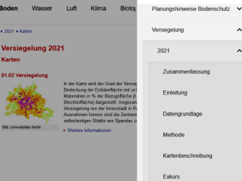
How do I navigate the website of the Environmental Atlas Berlin?
Image: Umweltatlas Berlin
The structure of the Environmental Atlas Berlin website as you know is changing as part of the ‘rebrush’ in April 2023. The website is now optimised for mobile devices. The hamburger button with the three parallel lines lets you navigate our website easily, also on a PC.
-
Can the Environmental Atlas provide me with data for a specific address?
Both the map view and the Geoportal feature an “address search”, which you can use to navigate to your desired address. Please note, however, that with few exceptions, e.g. some content-specific maps linked to Noise Maps and Green Roofs, the data in the Environmental Atlas is not collected for specific addresses but refers to specific statistical blocks or block segments. Since 2005, the block and block segment areas have been mapped on a scale of 1 : 5,000. Previous mappings were based on the scale of 1 : 50,000, which was neither true to location nor area.
Any conclusions drawn from the data for a block (segment) area therefore only apply with limitations to a specific address within the area. It may be the case, for example, that a value reflects the situation that predominates in a block (segment) area (e.g. for Land Use mapping) or the mean value of the block (segment) area (e.g. for Green Volume or Impervious Soil Coverage), which might be different from the situation in the plot of land for the specific address. -
Where can I find data that is updated daily?
The Berlin Environmental Atlas focuses on long-term trends and developments. Therefore, we do not provide data that is updated daily. These websites provide data that is updated on a daily basis for the following topics:
Air quality: https://luftdaten.berlin.de/lqi (only in German)
Water portal: https://wasserportal.berlin.de/start.php (only in German)
List of bathing areas (during bathing season): https://www.berlin.de/lageso/gesundheit/gesundheitsschutz/badegewaesser/liste-der-badestellen/ (only in German)
Digital platform urban traffic: https://www.viz.berlin.de/dps-portal (only in German)
Transport – Cycling:
https://www.berlin.de/sen/uvk/verkehr/verkehrsplanung/radverkehr/weitere-radinfrastruktur/zaehlstellen-und-fahrradbarometer/karte/ (only in German) -
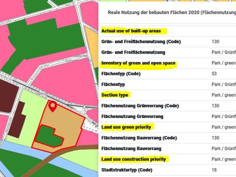
How do I find the maps and how can I use them?
Image: Umweltatlas Berlin
All topics include the “Maps” menu item, under which you will find either one or multiple maps pertaining to the topic. These are interactive map applications. There will also be other file formats on occasion. You can use them to get an overview of Berlin, or you can search for a specific address to obtain information on a certain location. To access the legend, click on the menu of the small window that contains the map. All maps include a link to the Geoportal as well, where you can access the factual data or combine the data with other geodata of Berlin. You also have the option for each Environmental Atlas map to download it as a PDF file (in A0 format).
-
Where can I download maps or geodata?
Most topics and editions of the Environmental Atlas feature the Web Map Service (WMS).
The Web Feature Service (WFS) enables the free download of geodata. Currently, WFS is not available for all data. This is the reason for this:In some cases, e.g. for grid data and large data volumes, the data may also be downloaded as an Atom feed.
Map and download services are not provided on the Environmental Atlas website. Geodata and metadata may be found here:
- The Geoportal Berlin provides links to the Web Map Service (WMS), the Web Feature Service (WFS) and Atom feeds.
- In addition to the Geoportal Berlin, the geodata search is also made available via the standard software GeoNetwork. It offers a variety of options for filtering the metadata. When you select a metadata record, the metadata is displayed. The metadata of the linked services or records may be accessed.
-
Why is WFS not available for all data?
The Web Feature Service (WFS) enables the free download of geodata. Currently, WFS is not available for all data. This is the reason for this:
In some cases, e.g. for grid data and large data volumes, the data may also be downloaded as an Atom feed.
-
What has changed with the discontinuation of the FIS-Broker in December 2025?
English attributes of a geoservice in the Geoportal Berlin
Image: Umweltatlas Berlin
The FIS-Broker has been replaced by a modern, open-source platform in December 2025.
Since then, only the new geospatial applications are available:- Geoportal Berlin for viewing data. Both services will be offered in German only,
- Geodata Search (Geodatensuche) for finding datasets in German only,
- Environmental Atlas Map Application in German only.
Links from the Environmental Atlas Berlin that pointed to the FIS-Broker have been redirected to the Geoportal Berlin. English-language maps from the FIS-Broker are no longer available. However, key attributes in English are included in the geoservices (WMS/WFS). They can be accessed in the Geoportal Berlin using the Query Information (Informationen abfragen) tool.
-
Where can I find the Environmental Atlas topic “Terrain Elevations”?
In 2010, the Environmental Atlas published the topic “Terrain Elevations”. Other Environmental Atlas topics often use this map as a data basis, which is then cited as “01.08 Terrain Elevations (Edition 2010)”. The Environmental Atlas Terrain Elevations map has a grid size of 5×5 m (DTM5) with a height accuracy of +/- 50 cm.
The official terrain model is published in the Geoportal Berlin under the name of “ATKIS® DGM – Digitales Geländemodell -” [DTM – Digital Terrain Model] and can be accessed in the Geoportal Berlin (only in German). Independent of scale, it provides basic information on elevations presented in a uniform grid with a grid size of 1×1 m (DTM1).
As a result, the Environmental Atlas map was discontinued on 11 June 2021. Please use ATKIS® DGM instead.
-
I am looking for older Environmental Atlas topics from the 1990s and 2000s and cannot seem to find them on this website. Why is that?
While restructuring our website in April 2023, some topics were removed from the Environmental Atlas, as they were severely outdated, no longer reflected the state of the art in science and did not belong to a time series. This is the case for the following topics:
From the ‘Soil’ section:- Heavy Metals in Soils, 1991
- Radioactivity in Soils, 1991
- Emissions: Sulfur Dioxide, 1991 and 1995
- Emissions: Nitrogen Oxides, 1991 and 1995
- Emissions: Dusts, 1991
- Emissions: Organic Gases and Vapor, 1991
- Traffic-related Air Pollution – Hydrocarbons, 1993
- Traffic-related Air Pollution – Others, 1993
- Near Ground Ozone, 1992 and 1995
- Bioindicators, 1991
- Temperature and Moisture Conditions in Medium Low-exchange Nocturnal Radiation Periods 1992
- Temperature in Medium Low-exchange Nocturnal Radiation Periods 2000
- Electromagnetic Fields, 1996
- Solar-Energy Surface Potential, 2005
- Vegetation, 1999
- Flora and Fauna, 1999
- Groundwater Dependent Ecosystems, 2003
- Heavy Metals in Plants, 1991
-
I have always been able to find the topics “Facilities Subject to Licensing”, “Aircraft Noise Protection Areas” and “TEHG Firing Plants” in the Environmental Atlas, but not anymore. Where can I find this data?
As part of restructuring our website in April 2023, the publication of these topics was entrusted to the responsible departments. They are therefore no longer part of the Environmental Atlas’ website. They may be found in the Geoportal Berlin, however, as well as on the relevant department websites.
Facilities Subject to Licensing Aircraft Noise Protection Areas TEHG Firing Plants -
Can I use the data in my BA or MA thesis or PhD dissertation?
Yes, you may use our data free of charge if you indicate the source. Click here to access our conditions of use and a template for citing the Environmental Atlas.
-
Can I use the data commercially?
Yes, you may use our data free of charge if you indicate the source. Click here to access our conditions of use and a template for citing the Environmental Atlas.