Soils vary greatly in their ecological properties, depending on parent substrate, grain size, composition, humus contents, relief profiles and depth to groundwater.
Important parameters that characterize the ecological properties of soils are: usable field-moisture capacity, aertion, cation exchange capacity, pH values, effective rooting depth, and summer moisture level.
Usable field-moisture capacity is a measure for the amount of water in soil available to plants. This is slowly moving seepage water and retained water in the coarse and medium pores of soil. Soil water in the fine pores (dead water) is subject to high water tension and cannot be taken up by plants. The amount of water stored in the soil is determined by pore volume, pore size distribution, grain size composition, and humus levels.
Aeration of the soil includes gas exchange by diffusion between the atmosphere and soil. Aeration is critical for the growth of plant roots and the existence and activity of soil organisms. The intensity of gas exchange depends on pore volume, particularly the amount of coarse pores, as well as their continuity. Other factors are grain size composition, structure, and the water content of the soil.
Cation exchange capacity is the amount of exchangeable cations bound to clay minerals and humus materials in the soil; e.g. Ca2+, Mg2+, K+, Na+, NH4+, H+. Cation exchange capacity gives indications of the soil’s ability to bind and store nutrients. This binding capacity, or nutrient storage capacity, depends on the type and amount of clay minerals, humus amounts, and pH values. Current actual nutrient levels in the soil can be lower than potential nutrient levels. The potential (maximum) cation exchange capacity for soil is given as a pH value of 8.2, and the effective cation exchange capacity for the current actual pH value of the soil is determined. Effective cation exchange capacity, air and water conditions, biological activity, and redox properties, etc. are important factors for an evaluation of nutrient levels actually available in the soil.
The pH value allows direct and indirect determinations of various processes and properties of soils, including a) weathering processes; b) soil formation processes, such as podzolization and clay translocation; c) species range and activity of soil organisms; d) humic material formation; e) structural stability; and f) the silting (mud filling) process.
The summer moisture figure is an expression for the water supply useable for the effective root area in critical dry periods during the main vegetation growth period. The figure takes into consideration usable field-moisture capacity, climate, relief, and groundwater.
Effective rooting depth is the depth in the soil where plants can draw water. Anthrosols can restrict rooting by impenetrable layers, e.g. concrete, lack of air, or the formation of methane in waste disposal site soils.
Soil Types
The near-natural soils in Berlin with a long developmental history and relatively uninfluenced by use are: luvisols (para-brown soils), podzoluvisols (leached soils), cambisols (brown soils), dystric cambisols (rusty-brown soils), spodo-dystric cambisols (podzol brown soils), podzols, gleysols, and histosols (bog soils). Histosols (bog soils) appear almost only in the less densely settled and unsettled outer edges of the city.
Luvisols (para-brown) and podzoluvisols (leached soils) are the most widely distributed soils in the sandy overlayered Barnim and Teltow boulder marl flat uplands. They are dealkalized to a depth of 1 – 2 m. Podzoluvisols (leached soils) occur mainly in forest areas. The greater humus and clay contents in the topsoil give luvisols (para-brown soils) a distinctively greater nutrient supply than podzoluvisols (leached soils). Luvisols have a medium to high storage capacity for water and nutrients and are well aerated. The pH values of topsoils in forest plantation areas are usually low at 3 – 4; with soil acidification by humic acids and “acid rain”. The pH values of agricultural soils are higher because of fertilizers and liming. The nutrient supply of forest plantation soils in the shallow root zone down to 0.3 m depth is low to moderate. The nutrient supply in the deep root zone down to 1.5 m depth is medium to high because of the increase in pH (Grenzius 1987). Podzoluvisols (leached soils) have a greater nutrient supply in the subsoil – Bt horizon – than topsoils with little clay. Water storage capacity and aeration are sufficient. Luvisols (para-brown soils) are good locations for agriculture, particularly in Rudow, Mariendorf, Lichtenrade (Teltow flat upland area), Kladow (Nauen plate), Hohenschönhausen, Hellersdorf, Weißensee, and Pankow (Barnim flat upland area).
Cambisols (brown soils) develop on the sandy areas of the Barnim and Teltow boulder marl flat upland areas, on the lower slope of flat upland areas, morraine hills, and end morraines. Cambisols develop particularly well as colluvial (transported) formations in the sometimes silty medium and fine sands of the Berlin pleistocene watercourse, the Panke valley, and in the sinks of dune landscapes. Stagno-gleyed and residual stagno-gleyed cambisols, and eutro-gleyic cambisols occur mainly in the pleistocene watercourse, depending on earlier and current groundwater levels.
Cambisols are deeply rootable and well aerated. They have a low, sometimes medium water storage capacity at lower slopes of end morraines through water inputs and deposits of clay. They are dry locations for shallow-rooted plants and fresh locations for deep-rooted plants. The stagno-gleyed and eutro-gleyic cambisols of the pleistocene watercourse were moist locations before the groundwater level sank. Cambisols usually have a moderate nutrient storage capacity, but the actual nutrient supply of cambisols with low pH values used for forests and grain production is very low to moderate. The nutrient supply is higher with greater humus contents and pH values, such as found in vegetable crop and horticultural areas.
Dystric cambisols (rusty brown soils) are found on the glacial sands of the Nauen plate (Gatow-Kladow), and the Barnim and Teltow flat upland areas. Dystric cambisols are also the dominate soils of the end morraines in the Düppel Forest, in Grunewald (Havelberge), in the Köpenick Forest (Müggelberge), the Gosenberge, and the Seddinberg. Dystric cambisols are also formed in valley sands remote from groundwater, such as in the Jungfernheide forest, and dystric cambisols, along with spodo-dystric cambisols (podzol brown soils), are the leading soils in dunes in the Spandau, Tegel, and Köpenick forests.
Both dystric and spodo-dystric cambisols are deeply rootable and well aerated. They posess a low to moderate usable field-moisture capacity and a medium nutrient storage capacity. They are very dry to dry and are very nutrient-poor locations. Their water and nutrient storage capacities are increased by interstratifications of silt in the subsoil, and by horticultural use, or in the vicinity of bogs (gleyed spodo-dystric cambisols or stagno-gleyed dystric cambisols, and dystric gleysols or spodo-dystric cambic gleysols).
The formation of podzol soils requires special climatic conditions, such as low temperatures and high precipitation. Podzol soils develop on fine-grained, lime-free sandy substrates. They only appear at a few locations in Berlin forests; mainly at the northeast slopes of dunes in the Tegel forest (cf. Grenzius 1987), the Püttberge in the Köpenick forest (cf. Smettan 1995), and in part of the end morraine formation of the Seddinberg.
Podzol soils are usually deeply rootable and well aerated, but in spite of their medium to high water and nutrient storage capacity, they are nutrient-poor and dry soils.
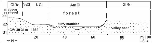
Gleysols form from sandy or silty substrate at locations with high groundwater levels. Gleysols appear in sinks of valley sand levels in the Spandau forest. They are dependent on relief profiles and are often associated with stagnic gleysols (wet gleys), histo-humic gleysols (turfy moulder gleys) and histosols (bogs). These are the soils of the sinks in the dunes in the Spandau forest and in the Schmöckwitz forest area south of Seddinsee lake; the meltwater channels such as the Kuhlake, Breite Fenn, Rudower Fließ, Tegeler Fließ, Wuhle, Neuenhagener Mühlenfließ, and the Krumme Laake; the dead ice sinks of the Großer Rohrpfuhl and the Teufelsbruch in Spandau, and the dead ice sink Teufelssee in Köpenick.
The ecological properties of gleysols differ greatly depending on the parent substrate, humus amounts, groundwater level, and the nutrient supply in the groundwater. Residual gleysols are also found in Berlin in areas of lesser depth to groundwater where groundwater levels have sunk. The residual gleysols have typical gley characteristics in profile structure, but their ecological properties differ very greatly from gleysols.
Gleysols are usually moist topsoil locations for shallow-rooted plants, and wet subsoil locations for deep-rooted plants. The available air supply is inversely proportional to the water level of the soil. This results in air-poor subsoil and, depending on water levels, a good to poorly aerated topsoil (sometimes alternately dry to wet), and medium rootability. Gleysols have a large to high nutrient storage capacity and a moderate to high nutrient supply, depending on humus amounts. The nutrient supply is high if additional nutrient inputs occur by way of the capillary uptake of eutrophied groundwater.
Residual gleysols are dry to very dry, well aerated into the subsoil, deeply rootable locations with generally medium to high water capacities. The nutrient supply is low to medium, depending on humus amounts and pH values. Nutrient input from groundwater is usually lacking.
Histosols (bog soils) have a high water level, are poorly aerated, and only shallowly rootable. Histosols have a very high water storage capacity and a medium to high nutrient storage capacity. They are undrained, near-natural locations with varying nutrient supplies.
Bogs are subject to drying and mineralization when groundwater levels sink. Properties relevant for plants change. Dried boggy (histosols) and turfy moulder soils (histo-humic soils) that appear in the Pleistocene watercourse, such as in allotment garden areas along the Teltow and Neukölln canals, and in Treptow along the edge of the Teltow flat upland area, are deeply rootable, well aerated, and moist locations, in contrast to intact bogs.
Loose lithosols (raw soils of loose material), regosols, and calcaric regosols (para-rendzinas) are relatively young soil formations, compared to soils that have developed for hundreds or thousands of years. They develop on young aggraded areas of eroded natural rocks, and at areas of anthropogenically aggraded materials.
Natural soil erosion occurs by the action of wind or water on the slopes of dunes, kames (short morraines crosswise to the flowing direction of the ice), and morraine hills. Anthropogenic soil erosion is caused by human use of soil. Soil inputs can occur both through natural translocation processes and through anthropogenic aggradations. Aggradations are differentiated into aggradations of natural material, such as soil excavation and gravel, and aggradations of artificial substrates such as war damage debris, construction debris, slags and cinders, etc..
Loose lithosols, regosols and calcaric regosols (para-rendzinas) of anthropogenically aggraded material undergo the same soil development as natural rock. The various parent material is described by the soil form, e.g. regosol of glacial sand, regosol of war damage debris, etc. (Grenzius 1987).
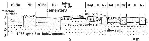
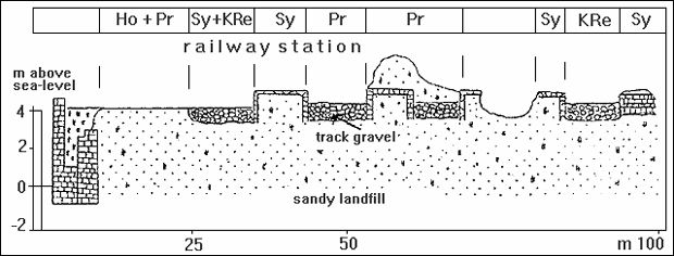
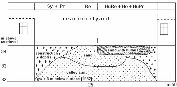
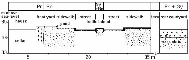
The soils of the Berlin urban area are characterized by intensive anthropogenic interventions resulting from the “rebuilding measures” of settlement, demolition of buildings, and damage incurred during the Second World War. There are large-area aggradations of war debris, slag and cinders, and building materials, as well as eroded areas due to construction of streets and railway lines, and the surface mining of gravel, sand, and clay. This has led to the wide distribution of loose lithosols, regosols, and calcaric regosols in the Berlin urban area.
Loose lithosols (raw soils of loose material) appear mainly on eroded areas of natural rock in the outer urban area. They develop where dystic cambisols (rusty-brown soils) and cambisols (brown soils) of glacial, valley, and drift sands have been removed by use, such as at military training areas and surface mining sites. Near-natural soils can still be found in small parts of lessly impaired areas.
Larger military training areas are located in Heiligensee at Baumberge, in the Grunewald forest, and in the Köpenick forest at Jagen 161. Surface mines in the Berlin urban area are at Kaulsdorfer Seen, the Kiessee Arkenberge in Pankow, the Tegeler Flughafensee, and the Laszinssee in Spandau.
Ecological properties are marked by natural undersoil and groundwater levels, e.g., loose lithosols created by erosion of dystic cambisols are well-aerated, usually dry, and nutrient-poor soils.
Loose lithosols (raw soils of loose material) at aggradation areas of anthropogenically transported rock (war damage debris, construction debris, railway track crushed rock, industrial crushed rock) are found at open areas throughout the entire densely-populated urban area, such as the inner city; at all areas greatly damaged or destroyed during the Second World War (soil association 52); and at industrial, and commercial locations. Loose lithosols also appear at war and construction debris disposal sites like the Eichberge in Köpenick, Arkenberge in Pankow, Teufelsberg in Grunewald, Trümmerberg in Friedrichshain, Volkspark Prenzlauer Berg, and at railway tracks throughout the entire urban area. Loose lithosols are more seldom at aggraded or translocated natural rock, such as landfill bullwarks at military training areas, including firing ranges.
The ecological properties of these loose lithosols are determined by the aggraded material. Loose lithosols of sands and artificial substrates form very dry to dry locations; tar or concrete layers in the undersoil form locations of periodic moisture. Aeration and thus oxygen suppy are good; rootability is restricted by high rock contents; rootability is deep in rock-free, sandy soils. Nutrient supply and storage capacity is low to high, according to parent rock and use.
The formation of regosols (cf. Grenzius) is a result of natural erosion (water and wind) and anthropogenic erosion (in Berlin often a high pedestrian load on slopes) of the loose lithosols on kames, morraines, or dune sands. The soil formation process is continuous. Humus accumulation in the Ah horizon results finally in regosols. These regosols appear, for example, on the steeper slopes along the Havel River in Grunewald, in the Düppeler forest, and on the slopes of the Müggelberge. Soil aggradation and erosion by the construction and closing (levelling) of sewage farms in the north of the boroughs Pankow, Weißensee, and Hohenschönhausen also influence the formation of regosols from natural materials. These are soil associations 60, 62, and 63.
Regosols of sandy, lime-free aggradations develop mainly in all urban areas of more dense construction, including smaller green areas and park facilities. They are usually nutrient-poor. Humus accumulation in the topsoil improves the nutrient supply. They often have a low water storage capacity, good aeration, and a deep to medium rootability, depending on the rock.
Calcaric regosols (para-rendzinas) develop from loose lithosols of limey substrate. Calcaric regosols of natural origin develop on eroded areas of marl pits which have been left open, on translocated marl, such as at foundation excavations, and on eroded slopes of bodies of water and channels of boulder marl flat upland areas.
Calcaric regosols develop in the bottom land of the Bäke at the Landgut Eule, and at Albrechts Teerofen from lime mud or disturbed shallow water sediments. This material was excavated for the Teltow canal and redeposited (cf. Grenzius 1987).
Calcaric regosols of anthropogenic aggradation material occur all throughout the entire densely built-up urban area at sites filled with war debris or construction debris; at all areas of heavy war damage with debris aggradations; and at railway facilities. Calcaric regosols are also found along the many landfill banks and bottom lands of the Havel and Spree rivers and their lake-like broadenings.
The higher clay levels of boulder marl calcaric regosols show an increased nutrient storage capacity, and a medium to high usable field-moisture capacity. Calcaric regosols of debris are nutrient-poor and dry. Aeration is good, the rootability of debris calcaric regosols is shallow because of the stone content. Calcaric regosols of lime muds are fresh, nutrient-rich, and good to poorly aerated locations, according to the groundwater level.
Selected Soil Associations
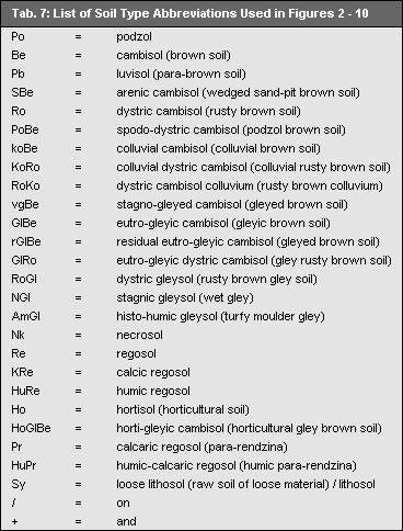
Some characteristic soil associations (SA) will be described here. A more detailed description of soil associations was made by Grenzius (1987). The depicted landscape segments originate from Grenzius’ dissertation (1987). The abbreviations used for soil types in Figures 2 – 10 are explained in Table 7.
Near-natural Soil Associations
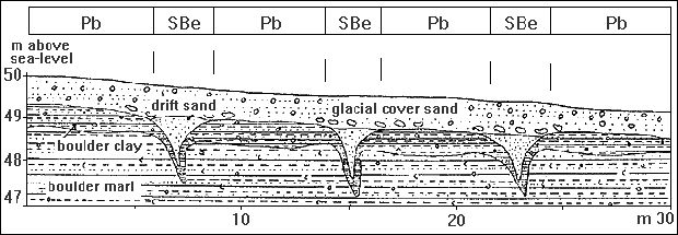
SA 1 [1010] Luvisol (para-brown soil) – arenic cambisol (wedged sand-pit brown soil)
(ground moraine flat upland area of boulder marl)
The parent material is flat upland boulder clay or marl. Shrinkage created wedges filled with sand; this was then overlaid with drift sand. A mixture of drift sand with boulder marl led to the formation of the glacial cover sand. Luvisols developed on the 1 – 3 m deep wedged sand-pits of arenic cambisols (wedged sand-pit brown soils) where the boulder clay and marl was covered with a thin glacial sand cover.
This soil association is particularly found at the Teltow and Barnim boulder marl flat upland areas.