The term population density is a measure of how many people live in a given area. Population density as used here is the number of inhabitants per hectare (1 hectare is an area about 86 yards on a side. 1 hectare = 2.47 acres, or 1 acre = 0.4047 hectare. 640 acres = 1 sq. mile). The population density of Berlin’s entire urban area is 37 people/hectare (p/ha). This figure is in the middle range for German and European cities. Hamburg has an average of 39 % fewer people per hectare. In the inner city of Paris the population density on the same area is almost twice as high (cf. Fig. 1).
New
The Environmental Atlas maps are available in the new Map Application
Population Density 2016
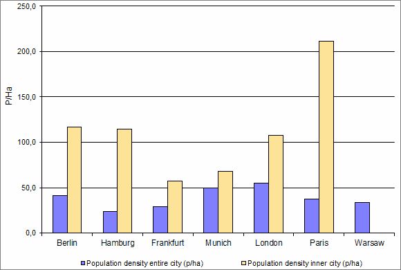
Fig. 1: Population Density of Berlin Compared to other Cities, in People per Hectare (Data from 2013-2016)
Image: Umweltatlas Berlin
Data status: Berlin / Munich: 31.12.2016; Hamburg / London: 31.12.2015; Frankfurt: 30.06.2016; Paris: Inner City: 01.01.2008, Unité urbaine: 31.12.2013; Warsaw: 30.06.2015. Definition of Berlin inner city see notes to fig. 2.
In Paris the inner city and the municipal border of the city area are overlaying; a reference value to the urban areas of the other cities is the goegraphical unit “Unité urbaine” with 10,601,122 inhabitants and 2,845 km².
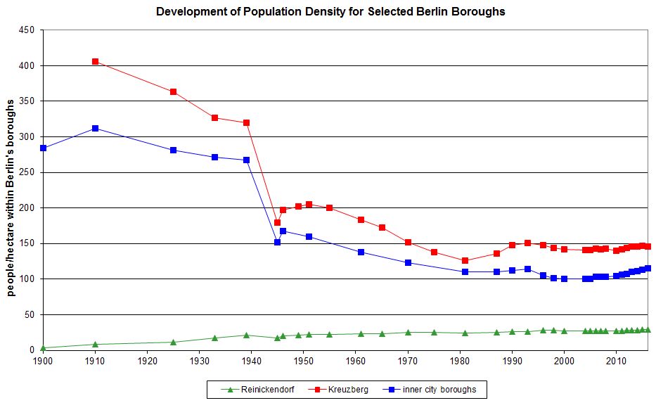
Fig. 2: Development of Population Density for Selected Berlin Boroughs (people/hectare within Berlin boroughs)
Image: Umweltatlas Berlin
Population figures for inner city boroughs existed only as a total sum for the years 1871 and 1900. No population data for the eastern city boroughs was available between 1949 and 1975. This prevented a calculation of population density for inner city boroughs for these years.
Environmental Atlas Contact
Berlin Senate Department for Urban Development, Building and Housing
Mr. Döllefeld