In recent years, increased construction activity and the associated increase in both impervious areas and the efforts of the Berlin Waterworks to expand the sewerage network into previously unconnected residential areas have resulted in new areas being connected to a sewerage system. This has been confirmed, too, by the most recent analysis, even though the methods used differ between the years 2012 and 2017. Overall, the share of areas connected to a sewerage system has risen by 2 % in the total built-up area.
Local rainwater management is becoming increasingly more important, which entails rainwater remaining directly on site and not being discharged. Only in case of difficult conditions (e.g. poor percolation properties), does this type of rainwater management require an additional, controlled discharge via drains. The distribution of this new type of rainwater management is not yet recorded in the current map “Type of Drainage”. It will be considered, however, going forward.
When analyzing how the different systems are distributed across the municipal area, the following key areas emerge.
In the inner-city areas of Wedding, Tiergarten, Mitte, Prenzlauer Berg, Friedrichshain, Kreuzberg Schöneberg, parts of Neukölln and Wilmersdorf, Westend and in the old town of Spandau, waste water and rainwater is drained together via the combined sewerage system.
Outer areas, including Reinickendorf, Pankow, Weißensee, Hohenschönhause, Marzahn, Hellersdorf, Lichtenberg, Köpenick, Neukölln, Tempelhof, Steglitz, Zehlendorf, Spandau, and parts of Wilmersdorf and Charlottenburg are connected to the separate sewerage system.
In Berlin, the prevalent type of separate sewerage system is that of rainwater drainage plus a sewerage system. Areas with this type of system are mainly found in outer areas, in the new boroughs of Spandau, Reinickendorf, Pankow, Lichtenberg, Marzahn-Hellersdorf, Treptow-Köpenick, Neukölln, Tempelhof-Schöneberg and Steglitz-Zehlendorf, as well as some south-western parts of Wilmersdorf-Charlottenburg, a small area in the north-eastern part of Mitte, and the Stralau peninsula in the south-eastern part of Friedrichshain.
To reduce the load on the combined sewerage system in some parts of Wilmersdorf, Weißensee and Spandau, as well as some areas of Charlottenburg, along Schloßstraße, rainwater sewers were built which discharge into the rain overflow drains of the combined sewerage system. There, sewage continues to pass through these combined sewers.
In areas with sewerage systems without rainwater sewers, rainwater percolation may be controlled or uncontrolled. These areas can be found at the outskirts predmoninantly in parts of Gatow, Kladow, Spandau, Staaken, Konradshöhe, Heiligensee, Frohnau, Karow, Adlershof, Biesdorf, Kaulsdorf and Köpenick.
The development of Category I old settlement areas (main areas to be connected to a sewerage system) has been completed (House of Representatives of Berlin 2009). The development of the Wartenberg settlement area was also completed in 2018 but is not part of the map. There are still further old settlement areas without sewerage systems. It was decided that the sewerage development of five of these areas (Biesenhorst, Buchholz Nord I, Schönholz, Karow Süd, Karow Ost) would be completed by 2030. The strategy for the remaining eight old settlement areas (Schmöckwitz-Werder, Schmöckwitz Schwarzer Weg, Neu-Venedig, Rahnsdorf-Süd, Siedlung Schönhorst, Siedlung Spreewiesen, Gatow Siedlung Habichtswald, Blankenfelde Altsiedlung) will be decided at a later stage.
What is more, there is still a variety of individual roads, that has not yet been connected to the central waste water treatment system either (gap closure areas). These will be developed successively. According to available documentation, there are also isolated plots of varied use (e.g. restaurants or sports facilities) outside settlement areas not yet connected to sewerage systems.
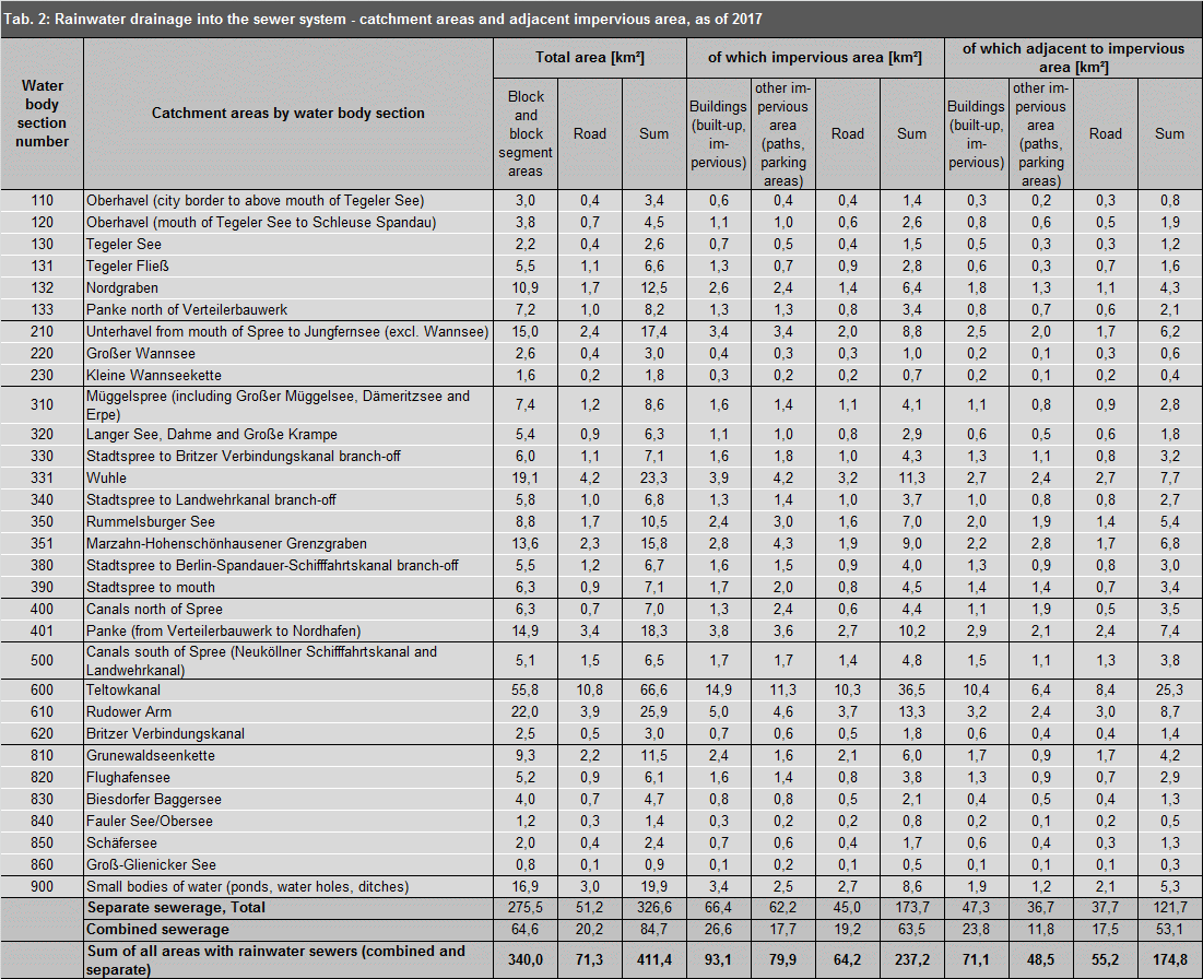
02.09.2 Catchment Areas of Rainwater Drainage
Depending on the main receiving water body, the catchment areas of rainwater sewers are found in the catchment areas of the Spree and Dahme rivers in the eastern and southeastern areas of Berlin, of the Havel river in the northern, northwestern and southwestern parts of Berlin, and of the catchment area of the Teltowkanal in the south of the city.
Lakes, park lakes, ponds and other blind drainage water bodies are spread over the entire area of the city.
Since within the inner S-Bahn Circle Line, the combined system prevails, and rainwater only rarely enters the water system, it has not been assigned to any rainwater drainage catchment area. The only exceptions are Tempelhofer Feld and parts of Wilmersdorf to the north of the urban motorway, which drain into the canals south of the Spree (the Neuköllner Schifffahrtskanal and the Landwehrkanal).