Peatlands 2015

Map Description

Map 01.19.1 Peatland Areas and Soil Types

Currently Berlin has about 740 ha of peatlands, which are mainly located in the less densely populated and developed outskirts. In total, 76 peatland sites were identified. A major part of the sites lies in the glacial spillway in the low-lying areas, such as the peatlands in the borough of Köpenick (e.g. Gosen Meadows). Further significant peatland areas lie in the Tegeler Fließ valley as well as in the nature protection area Lietzengrabenniederung/Bogenseekette, in the Grunewald (e. g. Teufelsfenn) and in parts of Spandau (e.g. Großer and Kleiner Rohrpfuhl). The sizes of the peatland areas of the individual mapped sites differ significantly. The largest contiguous peatland area in Berlin is formed by the Gosen Meadows with an area of more than 200 ha. By contrast, the peatland areas in the area "Kleines Fenn" and "Kleines Luch" in Schmöckwitz together only take up an area of about 0.3 ha.

The peat thicknesses also differ considerably between the individual peatland areas. The lowest maximal thickness was mapped at 0.7 m ("Moor am Plumpengraben"). The greatest maximal peat thickness of 12.60 m was probed at the centre of the Kleine Pelzlaake.

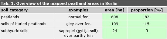
About 600 ha of the mapped peatland areas fall under the soil category of "true" peatlands according to the German Soil Classification System ([Ad-hoc-AG Boden] 2005, Table 1). The remainder mainly consists of buried peat soils, whose peats used to be exposed at the surface and have been covered by anthropogenic deposits. This is often accompanied by incipient mineral soil formation (e.g. gley over fen), for instance in the peripheral Erpe Valley. Increased water levels, partly also caused by peatland subsidence, often led to a new onset of peat formation, e.g. on the Meiereiwiese/Pfaueninsel. A small part of the mapped peatland areas belongs to the class of flooded, subhydric soils with current organic gyttja formation over peat.

Tab. 1: Overview of the mapped peatland areas in Berlin

Tab. 1: Overview of the mapped peatland areas in Berlin

From the perspective of soil science, half of the mapped true peat soils consist of so-called "normal types", which exhibit near-surface water levels and are currently not subject to permanent drainage (Table 2). Examples of peat soils with currently near-surface water levels are found e.g. in large parts of the Tegeler Fließ or on the Schmöckwitzer Werder.

Tab. 2: Overview of the mapped peat soil types in Berlin

Tab. 2: Overview of the mapped peat soil types in Berlin

Many of these peatland areas exhibit relictual earthification in their top soil horizons that indicates significantly lower past peatland water levels, e.g. due to increased drainage.

By contrast, the other half of Berlin’s peatland areas consists of currently drained and degraded peatlands that exhibit a recently formed earthification horizon of 1 dm or more at the surface. The most degraded and drained peatlands mainly lie in the western Grunewald. Here the local peatland water levels often lie more than 1 m below the current peat surface, particularly in the peripheral areas, due to the location in the cone of depression of the groundwater extraction for drinking water production.

A first assessment of the ecological state of the peatland and the soil is possible through the peat soil (sub)types. In principle, the "normal types" (Tab. 1) correspond to the target state and the drained earthy peatlands indicate degeneration and a need for action. The "normal types" offer valuable ecosystem services to humans, whereas drained peat soils not only perform fewer services; as sources of greenhouse gases (carbon dioxide) or nutrients (e.g. nitrate; sulfate) they even represent an environmental load and damage the climate, the groundwater and water bodies.

The level of soil (sub)types does not suffice for a differentiated assessment of different ecosystem services, and further parameters need to be adduced. For example, a fen (normal type) may be deeply earthified and eutrophic due to earlier drainage phases. Despite currently exhibiting near-surface water levels, it has lost ecological value, as rare plant species sensitive to eutrophication have been irreversibly displaced.

Map 01.19.2 Carbon Stocks of the Peatlands

The stored quantity of C that was calculated for the investigated peat soils amounts to more than 1 million tons. Hence Berlin’s peatlands withdrew more than 4 million tons of CO2 from the atmosphere over the course of the Holocene, thus contributing to global cooling (Holden 2005). The size of the C pools and the corresponding amounts of withdrawn CO2 of Berlin’s peat soils vary significantly and depend on the one hand on the respective peat area size and thickness, on the other hand on the chemico-physical soil properties. It is remarkable that the carbon stocks of the investigated peatlands thus account for one fifth of the entire carbon stocks in Berlin’s soils with a share of 0.8 % of the area. The carbon stocks of approx. 5 million t C determined for all of Berlin’s soils from the map Organic Carbon Stocks 01.06.6 are at least in this order of magnitude but were merely estimated using a different, significantly less precise method.

The largest C pool of over 150,000 t (equiv. to 559,000 t CO2) is stored in the peat soils of the Gosen Meadows, due to their large area. However, because of the relatively low peat thicknesses the relative storage quantities here are in the lower range of Berlin’s peat soils, with less than 800 t/ha. The most area-effective C storage is found in the thick peat soils of the Kleine Pelzlaake. Here a maximal C storage quantity of more than 6,000 t/ha was calculated at the centre of the peatland. The average C pool in the Kleine Pelzlaake lies above 3,700 t/ha. There are further important C pools in the peat soils, e.g. in the peatlands of the Tegeler Fließ.