Runoff Formation 1990

Methodology

Evaporation

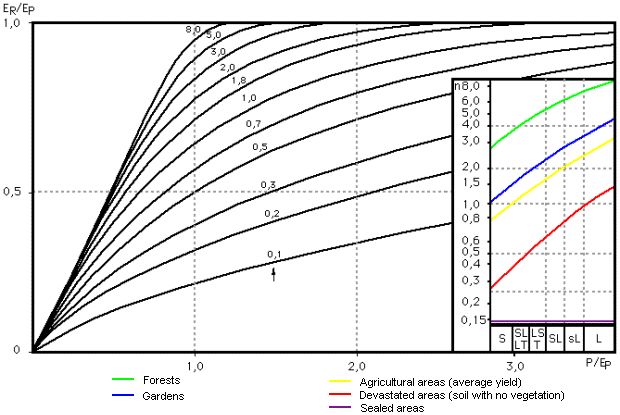
Runoff is calculated from the difference between long-term annual mean precipitation and actual evaporation. Actual evaporation, as it actually averages at specific locations and general areas, is calculated from the most important factors of precipitation, heat supply (radiation balance), and the average storage properties of evaporative areas. Potential evaporation is a calculation where the heat supply is replaced by quantities of evaporated water corresponding to the amounts of heat. Sufficient inputs of moisture to evaporating areas allow actual evaporation values to approach potential evaporation values. Actual evaporation is modified additionally by the storage properties of the evaporating area. Greater storage effectiveness, such as a greater cohesive capacity of the soil and greater root depth, causes greater evaporation.

The demonstrated connection between actual evaporation to precipitation, potential evaporation and the evaporation effectiveness of the location is satisfied by the relationship according to Bagrov (cf. Glugla et al. 1971, Glugla et al. 1976, Bamberg et al. 1981 and cf. Fig. 5). The actual evaporation ER for locations and areas not influenced by groundwater can be determined by the Bagrov relationship with knowledge of the climate factors precipitation (P), potential evaporation (EP) (quotient P/EP), the effectivity parameter (n), and the quotient actual evaporation/potential evaporation (ER/EP). The Bagrov process is also used in modified form for calculations where groundwater influences evaporation; the average capillary water inflow from the groundwater is added to precipitation.

Fig. 1: Depiction of Bagrov Equation for Selected Parameter n and Dependency of Parameter n on Land Use and Soil Type

Fig. 1: Depiction of Bagrov Equation for Selected Parameter n and Dependency of Parameter n on Land Use and Soil Type

Increasing precipitation (P) causes actual evaporation (ER) to approach potential evaporation (EP); i.e. the quotient ER/EP approaches the value 1. Decreasing precipitation (P) (P/EP inclines to value 0) causes actual evaporation (ER) to approach precipitation (P). The intensity with which these boundary conditions are reached is changed by the storage properties of the evaporating areas (effectivity parameter n).

Useful Field Capacity

Local storage properties are especially influenced by forms of use. Use forms classified in order of increasing storage effectiveness are: sealed areas; soil with no vegetation; agricultural areas; gardens or forests. Soil type is also an influence (greater soil cohesiveness increases storage effectiveness).

Useful field capacity is a measure of the storage effectiveness of unsealed soil. It is the difference between soil moisture values for field capacity (beginning of infiltration into the soil) and for the permanent wilting point (lasting dessication injury to plants). Other land use factors modify the parameter value n, such as crop production per hectare, tree type and age. The parameter n was quantified by evaluating observation results of numerous domestic and foreign lysimeter stations and by water balance studies in river catchment areas.

Capillary uptake of groundwater into the evaporation-influenced soil zone increases evaporation rates in locations and areas with near-surface groundwater according to the depth of groundwater from the surface and soil properties. The formation of runoff declines. Water depletion occurs if actual evaporation exceeds precipitation. Runoff values then become negative, such as at lowlands of rivers and lakes.

An increased potential evaporation appears at water surfaces in comparison with land areas, because of the greater heat supply (lesser reflective capacity of incoming radiation). Actual groundwater evaporation, as an approximation, is assumed to be equal to increased potential evaporation.

Estimation of the Method of Calculation

The meaningfulness and precision of the calculation method was tested by comparing calculated total runoff with observed runoff values of closed river catchment areas. The mean deviation of calculated runoff from observed runoff was then determined. The deviation was approximately ± 15 to ± 10 % for areas with a size between 25 and 50 km2 ; approximately ± 10 to ± 5 % for areas between 50 to 1,000 km2 ; and under ± 5 % for areas larger than 1,000 km2. An average deviation of about ± 25 % is estimated for the individual grid areas (1 km2) presented here. The calculated values for outflow were rounded off at 5 mm/a. Runoff calculations were performed with the calculation program GRID – _RASTER_ (cf. Glugla et al. 1989).

Certain types of local percolation were not taken into consideration, such as groundwater recharge for waterworks. Garden watering was added to precipitation in the form of a uniform approximate value.