Urban Structure / Urban Structure Differentiated 2010

Map Description

Description of mapping units

The 52 different section types which are available as mapping units for the urban structure are categorized into six groups. This is designed to facilitate a logical assignment of types to the various uses, to support the mapping process. For example, block sections with residential use can only be assigned to section types belonging to the group “Section types with residential use and residentially characteristic mixed use”. In Environmental Atlas Map 06.07, similar section types are grouped into 16 overarching structure types, for better readability. The definition and description of section types can also be seen in the report on the documentation of mapping units and updating of the database.

Tab. 1: Section types with residential use and residentially characteristic mixed use

Tab. 1: Section types with residential use and residentially characteristic mixed use

Section types with residential use and residentially characteristic mixed use

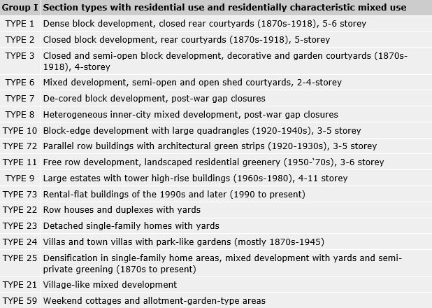
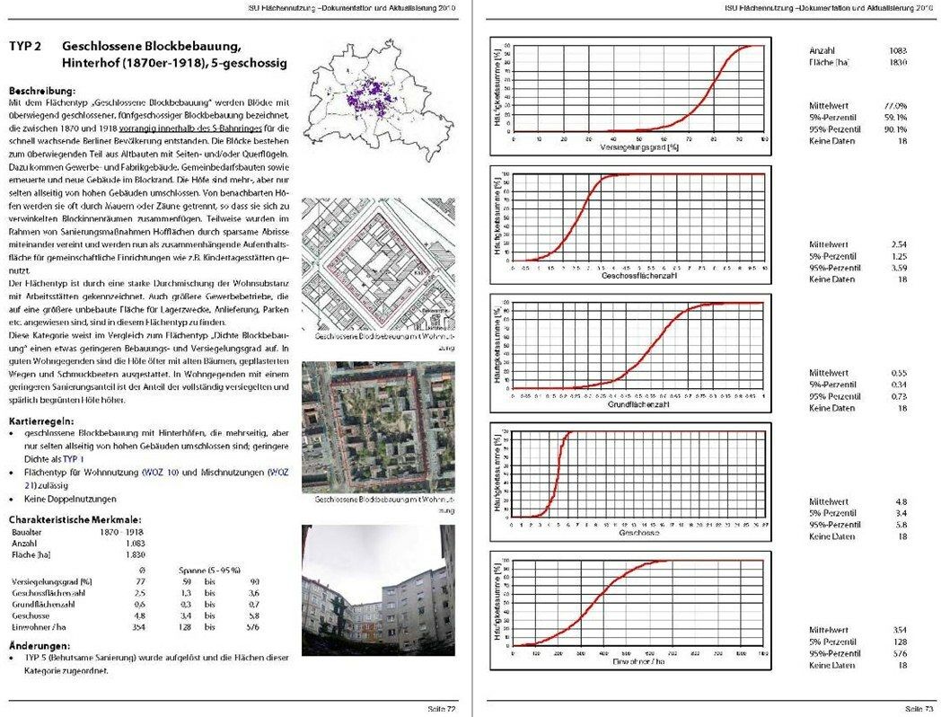
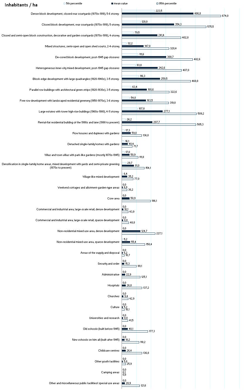
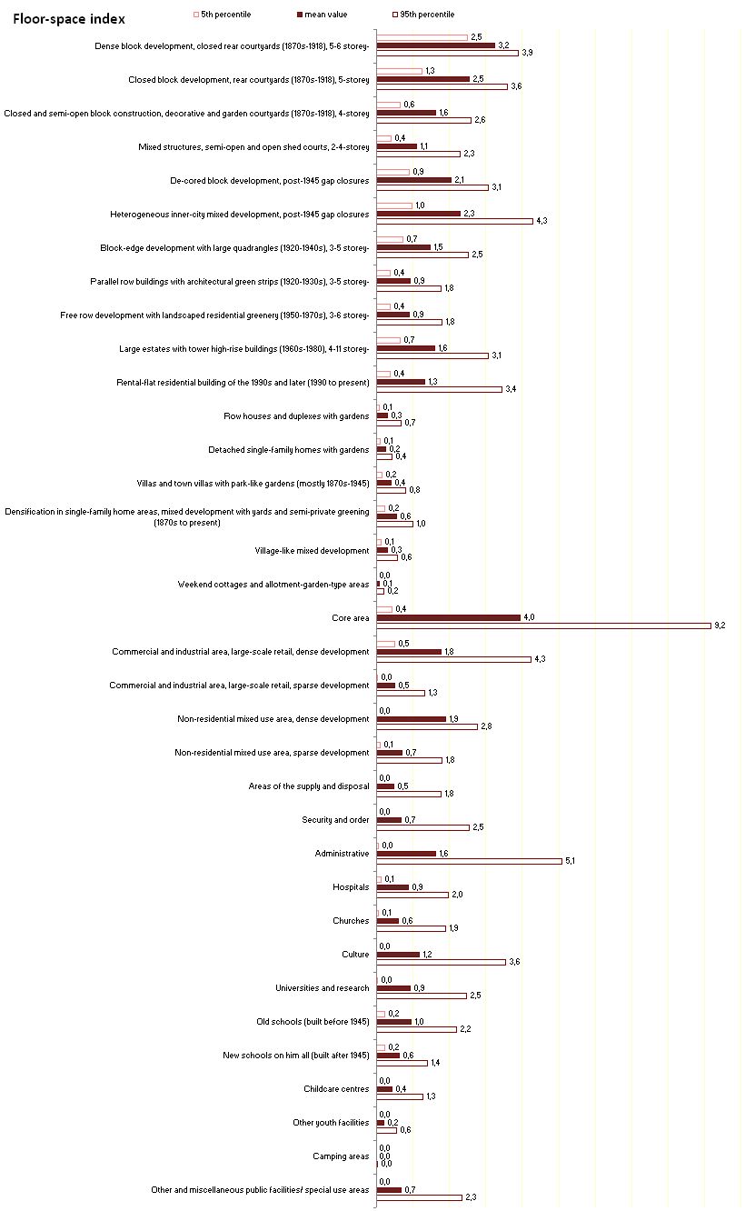
The section type “Dense block development, closed rear courtyards (1870s-1918)” emerged during the early 20th century in order to maximize land utilization for residential purposes. It is largely found inside the city rail (S-Bahn) Circle Line, and is characterized by close blocks of 5-6 storey buildings. Often, there are several courtyards, usually entirely surrounded by buildings and connected with one another only by passageways; some of these courtyards are only the size of a light shaft. Sometimes, the courtyards are commercially used; usually however, they merely serve the purpose of access to the wings and rear buildings, and as placement for rubbish bins. Particularly in the case of commercial utilization, these courtyards are virtually completely impervious. This section type is thus the most densely built-up and also the most impervious type of residential area.

The section type “Closed block development, rear courtyards (1870s-1918) , 5-6 storey” designates blocks with primarily closed 5-storey block construction, also built during the same period, also within the Circle Line, for the rapidly growing population of Berlin. The blocks consist largely of old buildings with wings and/or parallel rear buildings. In addition, there are also commercial and industrial buildings, public facilities buildings and restored or new buildings at the block-edges. The courtyards are encompassed by high buildings on several sides, but only rarely on all sides. There are often separated from neighbouring courtyards by walls or fences, so that they together constitute angled interior block spaces. Often, courtyard areas have been connected with one another in the context of renovation measures by means of partial demolitions, and are now used as comprehensive areas for such public facilities as childcare centres etc.

This section type is characterized by considerable mixture of residential areas and workplaces. It also includes larger commercial operations which require large non-built-up spaces for storage purposes, deliveries, car parks etc.

This category has a somewhat lesser degree of density and impermeability than the section type “Dense block development”. In better neighbourhoods, the courtyards often have with old trees, paved walkways and decorative flower beds. In residential areas with a lesser degree of renovation, the share of completely impervious and minimally green courtyards is higher.

The section type “Closed and semi-open block development, decorative and garden courtyards (1870s-1918) , 4 storey”, is characterized by 4-storey block construction, often with front yards. The blocks with decorative and garden courtyards were often built during the imperial era (1870-1918) in the then-suburbs of Berlin outside the Circle Line (the edge of the inner city). These buildings have only wings or only parallel rear buildings, but generally not both. They are characterized by a much sunnier interior block space than is the case for the above two section types; it is usually designed as a garden.

The section type “Mixed development, semi-open and open shed courtyards, 2-4 storey” is characterized by open mixed structures, particularly at the edge of the inner city and at the edge of the city, and is there especially associated with the old village cores and sub-centres. There are some remains of old structures which were there before 1870, sometimes low, old buildings, sheds and workshops in the courtyards, and these areas are also interspersed with buildings associated with the 4-storey construction of the “decorative and garden courtyard” type, as well as new buildings – both single-family and multifamily houses, and rental-flat buildings – built after 1945. Accordingly, the appearance of these areas is fairly heterogeneous. Their characteristic feature is interior block spaces broken down into small parts, often with commercially used workshops and storage areas and parking spaces, but also some privately used vegetable gardens and orchards.

The section type “De-cored block development, post-war gap closures” is scattered throughout the imperial-era residential neighbourhoods in the inner-city and the inner-city edge. The old buildings destroyed in the Second World War were replaced by the reconstruction of those buildings, or by new buildings in the gaps. Generally, the new buildings were placed along the same building lines as the old ones, so that this section type is largely characterized by closed block-edge construction, which is however sometimes interrupted by driveways, car parks, gaps, etc.

In the context of modernization with the new construction of front buildings, it was not uncommon for all lateral and rear buildings, as well as sheds, to be torn down. The result was a block interior area that was more open than the original structure; generally, it is subdivided at the lot boundaries by fences. In addition to the old structuring of the courtyards, these areas are often dominated by car parks surrounded by green space, such as lawns and bushes. In some cases, however, relatively large interior spaces were created, which have been designed as leisure spaces for the inhabitants, with green spaces and lawns, playgrounds and benches, or with such public facilities as childcare centres.

The section type “Heterogeneous inner-city mixed development, post-war gap closures” is also located within the residential neighbourhoods built during the imperial era. Here, unlike the previous section type, high-rise buildings with rental flats and offices were often built as rows or single towers in the block sections, often with no regard for the historic building lines or building heights of those streets. Remainders of imperial-era buildings are only sporadically present. The blocks have neither block interior spaces nor closed semiprivate courtyard areas. The non-enclosed open areas serve as car parks in the form of underground or surface parking. The other open areas are largely designed as non-usable green fringe.

The section type “Block-edge development with large quadrangles (1920-1940s) , 3-5 storey” designates the type of block-edge construction with large residential inner quadrangles, which was typical for the period from the late ’20s to the mid-‘40s.

The large quadrangles were formed by the complete or near-complete enclosure by 3 or 4-storey buildings directly on the street line. They were associated with more or less representatively designed entry areas, and sometimes semi-public passageways connecting the quadrangles with the streets. The quadrangles were almost entirely green, and characterized by an architecturally symmetrical design. In some early estates, the quadrangle was apportioned into residents’ gardens surrounded by hedges. Otherwise, the predominant form was an open space design with lawns and scattered old trees. Particularly characteristic were such “informal” species as birch or willow, which contrasted with the symmetrically arranged, “architecturally-shaped” trees, such as cottonwood and spruce. Access paths were generally sparingly designed; however, parking garages were in some cases added later.

The section type “Parallel row buildings with architectural green strips (1920-1930s) , 3-5 storey” describes the row housing of the 1920s and ’30s. During the late ’20s and ’30s, the first row houses in Berlin were built. The main purpose was to achieve optimum utilization of the lots, and to provide much light, air and sun to all the residences. The long rows of 3-5 storey houses were arranged parallel to one another. The free space between the houses is narrow and elongated, and open on the short sides.

The row houses give the streets a spatial closure, since they were not detached in the middle of the lots, as would later, during the ’50s, be common, cf. next section type. Rather, they were uniformly arranged at right angles to the street, so that their narrow edges together formed the building line. In some cases, terminal lateral buildings were arranged parallel to the street, so that a mixture of row and block-edge construction emerged, resulting in variegated exterior spaces. Passageways, vistas and jutties were used to visually break up the appearance of these streets. Moreover, the street space was varied by placing the buildings in front of or behind the building line, and with local extensions. Front yards were almost always provided.

The section type “Free row development with landscaped residential greenery (1950-1970s) , 3-6 storey” emerged during the post-war period, primarily during the ’50s through the ’70s, in the context of the reconstruction programmes. The elongated mostly 4-storey blocks of houses arranged in rows were for the most part build as coherent estates in former residential areas badly destroyed in the war in the inner-city, and along the edges of the densely built-up areas at the inner-city edge.

Unlike the row housing of the ’20s and ’30s, the construction was no longer oriented directly toward the existing street grid. It is often oriented in an east-westerly direction, in order to provide more sunlight for the flats, but is no longer as strictly parallel as the rows built during the ’20s and ’30s. In the later years, the rows were often built in a staggered and shifted arrangement, or arbitrarily lined up along a curving pattern of streets. During the 1970s, designs in chain or spider-web form also emerged. By contrast with the next section type, “Large estates with tower high-rise buildings”, each estate generally had uniform designs and heights.

The buildings of the section type “Large estates with tower high-rise buildings (1960s-1980) , 4-11 storey” appeared between the late 1960s and the end of the ’80s. Often, these were comprehensive large-scale residential areas at the edge of the city (satellite towns), mostly built by concrete plate construction. Smaller estates with row or block development can be found in the sub-centres and in the inner-city area. In the eastern part of the city, concrete plate construction was sporadically used even within the historic structural area.

Typically, unlike the row development of the 1950s to ’70s (cf. previous section type), various building heights and designs were used within the same estate. Often, these were 4-8 storey, semi-open block-edge developments, or mixtures of block-edge and row developments, which were in some cases combined with single tower high-rises or high-rise chains of ten storeys or more. Especially in the major estates, the buildings were often placed with no reference whatever to the streets, so that there is no homogeneous spatial street structure.

Large, non-enclosed open spaces often exist between the buildings, surrounded by large numbers of surface car parks. The pervious surfaces are largely covered by lawns and shrubbery.

The section type “Rental-flat residential building of the 1990s and later” includes those areas built since the beginning of the 1990s, which are considerably different from the typical large estates (cf. previous section type), and include a wide range of urban development structures, e.g. block-edge, row houses, town villas and townhouses. For the most part, these are major residential development projects of the 1990s and the first years of the 21st century, which have been carried out in the context of major urban development measures such as Wasserstadt Spandau, Rummelsburger Bucht, Karow Nord, Buchholz etc. By contrast, single-family housing areas, row house and duplex estates built during the 1990s and later are assigned to the section types with unspecified building age (cf. the next two section types described).

Open spaces and interior courtyard areas of the estates built since the 1990s are often designed as semi-public green spaces with playgrounds and leisure areas; the ground-floor flats often have terraces or small garden areas. Car parking space is increasingly being provided in underground garages. Moreover, the estates built since the 1990s have a relatively energy-saving, in some cases ecologically oriented type of construction, thanks to current standards (relatively good insulation, in some cases passive houses, rainwater seepage, greened roofs, etc.).

The section type “Row houses and duplexes with yards” describes row house estates or closely arranged duplexes with more or less longitudinally extended yards.

Until 1945, the sizes of the garden plots were dimensioned so as to be able to provide subsistence in vegetables, potatoes and fruit, and permit holding of small animals and chickens. A certain share of vegetable and flower beds, fruit trees and bushes can still to some extent be seen in these old row yards, even to this day. Until 1945, these houses were always built around the block edges, so that the yards in the block interiors formed large continuous green spaces.

The modern row houses are usually no longer built along the block edges, but rather arranged along spur roads or access paths which lead into the interior of the block sections. As a result, there is no longer any common open interior block space, but rather only rows of individual gardens screened off from the neighbours. Since the 1990s, there has been a trend toward space-saving construction, with smaller lot sizes resulting in increased shares of built-up areas on the lots, so that the yards barely cover half the lot areas. The yards of the duplexes are somewhat larger than those of the row houses. This section type is nonetheless one of those with the highest shares of open space.

The section type “Detached single-family homes with yards” includes on the one hand single family housing areas, in which the houses are mostly built along a single building line behind front yards of equal depth, and in which small, single multifamily houses with appropriate garden plots are integrated only sporadically. Behind the houses are the actual yards, which are today largely used for leisure activity or as decorative gardens, and only to a lesser degree as fruit and vegetable gardens. At the level of the entire block, this yard area constitutes a large free space which is however subdivided by fences and hedges.

On the other hand, this section type also includes residential areas characterized by usually unplanned, non-homogeneous building designs with a mixture of 1-2-storey buildings including single-family homes, bungalows, workshops and garages of various ages.

Such open residential areas are located in the outer areas of the city adjacent to the more densely built-up areas, and at the city edge. Often, the structural density of these areas has been increased by the construction of buildings on so-called “hammer lots” (the rear half of a lot with a narrow driveway access), and later densification with multifamily houses and rental-flat buildings (cf. below, section type “Densification of single family home areas”).

The section type “Villas and town villas with park-like gardens” includes residential areas with villages and townhouses, largely from the imperial-era through the end of the Second World War (1870-1945). Villas are representative single-family homes with yards. Town villas are similar to villas in design and overall appearance, but are multifamily houses with somewhat larger volumes. Although they have the same use characteristics, these areas have larger lots and greater building volumes than those of the section type “Detached single-family homes with yards”. These buildings have front yards of uniform width, along a single building line, and are relatively close together at the block-edges. They form easily recognizable interior block spaces. The lots are separated by hedges or walls, and in some cases my old brick buildings, which were previously sheds or guard houses. In the case of town villas, the interior block space is sometimes relatively small, due to the larger building volume. The park-like impression of these gardens is created by the old trees which are very large, and in some cases exotic species. Sometimes the gardens include vegetable and flower beds; however, lawns with trees are dominant.

This section type rarely appears in pure form over an entire block, since the gaps caused by wartime damage have been filled by buildings of other styles. In addition, the pressure of change due to densification is great, due to the relatively large sizes of the plots in this section type (cf. also the next section type).

The section type “Densification of single-family home areas” developed from areas of the section types “Detached single-family homes with yards” and “Villas and town villas with park-like gardens”. Since, especially in West Berlin, there was not sufficient free construction land available, there was a tendency during the second half of the 20th century to tear down old villas and single-family homes and to replace them with newly built larger rental-flat or studio-apartment buildings, or to divide the lots and to build more houses in the former park-like gardens. The generously dimensioned interior block sections are now interspersed with buildings.

The new buildings are in many cases multifamily houses or rental-flat buildings where there are no longer any yards, but rather only a semiprivate green strip surrounding the entire building. The imperviousness and structural coverage degree of this section type is accordingly higher than it is for the two section types from which this emerged. This phenomenon is particularly notable in the south-western part of the city.

The section type “Village-like mixed development” is located in the area of the old village cores and, due to more recent development, particularly that in the open spaces, can only be found outside of the Circle Line, and very rarely in completely preserved village structures (e.g. Kladow, Marienfelde, Buchholz, or Heiligensee). The village buildings today consist of a mixture of new buildings and typical farmhouses, as well as the old buildings of the former village cores. The decisive factor is that the open space elements of the village, such as the old streets, the village green, the village pond, the manor park, the cemetery at the church, etc., are at least partially visible, and in the areas at the edge of the city are in some cases largely still preserved.

The typical old village buildings are 1-2-storey residential buildings along the streets with farm yards behind them, often enclosed by farmyard buildings of brick. Behind these are fruit and vegetable gardens. The low height of the buildings has been supplemented around the edges of the inner-city by single and multifamily homes. In addition to their residential function, the old village areas today function as local sub-centres, with shops, retail facilities, administrative centres, small workshops, riding stables, restaurants and garden cafés in the old farm buildings.

The section type “Weekend cottages and allotment-garden-type areas” includes all block sections which are shown on the actual use map as weekend cottage and allotment garden type uses. Weekend cottages are, by definition, not permanently inhabited, and are largely for leisure use. By contrast with single-family home construction for residential use, these blocks generally have low building volumes and small-scale land parcels. Compared with allotment garden areas, these areas are, however, more densely built up, and the parcels tend to be larger.

Tab. 2: Section types of mixed, commercial and industrial uses, and Utilities

Tab. 2: Section types of mixed, commercial and industrial uses, and Utilities

Section types of mixed, commercial and industrial uses, and Utilities

The section type “Core areas” has all block sections assigned to it which are shown in the actual use map as core use areas. These are areas with high use intensity and density which are located exclusively in the central areas of the inner city and in the major borough centres. The core areas are of overarching significance for commerce, private and public services, and cultural and scientific institutions. Sometimes public facilities in the inner-city area, such as federal administrative buildings, embassies, etc., are assigned to this category.

Structurally, there are major differences between particular areas. The spectrum extends from imperial-era block construction to more recent high-rise construction. Generally, these areas are characterized by a high degree of urban density and of imperviousness.

The section type “Commercial and industrial areas, large-scale retail, dense development” describes areas with a corresponding use in which more than half of the area of the respective lot is built up and intensively used. Especially at the edge of the city, commercial and industrial areas have the typical structural design with large building cubatures. By contrast, the structural design in the inner-city areas, especially in small blocks, tends to include smaller structures adapted to the surroundings.

The section type “Commercial and industrial areas, large-scale retail, sparse development” describes areas with a corresponding use in which one half or less of the respective lot is built up. The use of these large lot areas is here almost exclusively for the purposes of commercial production, the storage and shipment of goods, or as car and truck parks. There is virtually no residential use here.

Commercial areas with sparse development are increasingly located at the edge of the city, especially in areas with favourable traffic conditions, such as motorways, rail connections and waterways. There buildings are predominantly single-storey structures built during the post-war period, with generous surrounding spaces. In underused areas, these facilities are often interspersed with fallow areas. Generally these areas have a lower level of imperviousness than the commercial and industrial areas with dense development.

The section type “Non-residential mixed use areas, dense development” describes block sections with mixed use, in which more than half of the respective lot is built up, and the open spaces are almost entirely used as car parks or storage space. They are characterized by a mixture of residential and commercial use. The external appearance is largely marked by commercial use; the characteristics of residential use are little in evidence, so that the block cannot be assigned to any of the section types with residential character (see above, Group I).

This section type occurs mostly in inner-city densely built-up areas and in the centres of the outer areas of the city. It involves primarily multi-storey structures, often with storefronts and storage or manufacturing halls in the courtyards. The lot areas are more than half built-up.

The section type “Non-residential mixed use areas, sparse development” describes block sections with mixed use in which half or less of the respective lot is built-up. The commercial structures, which were only recently built, particularly in the outer city boroughs, consist primarily of single-storey halls and building complexes with large surrounding open spaces.

The commercially used areas involve primarily commercial operations with a high share of storage, shipment and car and truck parking (junkyards, dealers in building materials, shipping companies and retail businesses). They occupy a major part of the block section, so that the block cannot be assigned to any of the section types with residential character (see above, Group I). There are also large areas which are unused or only extensively used, on which spontaneous vegetation in varying phases of development is located (fallows). Generally, these areas have a lower degree of imperviousness than the mixed areas with dense development.

The section type “Utilities areas” includes all block sections shown in the actual use map as Utilities areas. This category includes areas with facilities for electricity, gas, water and district heat supply, as well as waste and sewage disposal.

Tab. 3: Section types of public facilities/ special use

Tab. 3: Section types of public facilities/ special use

Section types of public facilities/ special use

All block sections shown on the actual use map as Public facilities/special use areas are assigned to one of the following section types:

The section type “Security and order” includes areas belonging to the police, the fire department, the prison system, the military etc.

The section type “Administrative” is assigned to the locations of public administrative offices. These include e.g. the borough offices, the town halls, the job centres, the courts, Senate departments, and such federal facilities as the Foreign Ministry and the Bundestag. By contrast, embassies are assigned to the category “Public facilities/special use”.

The section type “Hospitals” includes both the structural facilities and the sometimes very extensive external grounds of each such institution. The time of construction of the hospitals is spread throughout the various construction eras. The hospital facilities built in the early 20th century were in many cases built in pavilion style. The relatively large external areas were designed as parks, and include extensive access facilities. In later years, the style of construction was abandoned in favour of the central main building. However, large park-like external areas are usually typical here, too.

The section type “Churches” is assigned if a considerable portion of the area of a block is occupied by church buildings. They often occur in connection with city squares or cemeteries, and may be mapped accordingly, as dual use areas.

The section type “Culture” includes city museums, theatres, operas, the Philharmonic, etc. It also includes large-scale memorial graves and monuments.

The section type “Universities and research” includes primarily the universities and colleges, as well as their associated teaching and experimental fields with agricultural or horticultural character, which are shown in the use map as public facilities/special use areas with corresponding open space dual use; in addition it includes several scientific research facilities.

The section type “Old schools (built before 1945)” describes the schools built around the turn of the last century through 1945, on relatively small lots in the neighbourhoods characterized by imperial-era block construction. Their structural style is similar to that of the imperial-era section types. The non-built-up areas are used as leisure courtyards with playgrounds, or, rarely, as sports facilities.

The section type “New schools (built after 1945)” describes the schools built since 1945. Particularly the centres built during the 1970s have very large lots, the non-built-up areas of which are used as leisure courtyards, playgrounds, or sports facilities.

Both section types, New schools and Old schools, include exclusively general educational and vocational schools. The locations of music schools, horticultural schools, “people’s colleges”, etc., are assigned to the section type “other public facilities/special use areas” (see below), since they do not have the buildings and open spaces typical of schools.

The section type “Children’s day care centres” covers larger childcare centres occupying entire blocks. Smaller institutions are generally mapped in combination with other public facilities, such as schools or residential areas. The buildings built since the Second World War are usually 1-2 storeys high; in rare cases they have three or more storeys. The old buildings have been adapted to the building style of the surroundings. Childcare facilities have very high open space shares, which are often intensively designed and used as recreational and play areas.

The section type “Other youth facilities” includes larger youth facilities sites which cannot be assigned to any other category, e.g. youth clubs, youth recreational centres, youth training centres, children’s and young people’s homes, children’s and young people circuses, school country centres, traffic schools and youth hostels and guesthouses.

The section type “Camping grounds” includes tent grounds and scouts’ tent grounds, camping grounds and permanent campgrounds with mobile shelters, but not purely caravan camping places with an impervious parking-area-like characters. Built-up areas include sanitary buildings, and some shops or restaurants, but the share of built-up areas overall is relatively slight.

The section type “Other and miscellaneous public facilities and special use areas” includes all public facilities areas which, as a result of lack of information or due to the nature of the system described herein, cannot be assigned to any other common use or public facilities section type.

Tab. 4: Section types of green and open space uses

Tab. 4: Section types of green and open space uses

Section types of green and open space uses

The section type “Forests” includes all areas mapped as the use category “Forests”, unless they at the same time have some structural use. In that case, the type assignment is in accordance with that structural use. In addition, some areas mapped in the use category “Parks/green spaces” may be assigned to this section type, if they are predominantly extensively cared for areas planted with trees (e.g. Glienicke Castle Park).

The section type “Bodies of water” is assigned to all block sections which are also shown as bodies of water in the actual use map. Bodies of water include not only natural waters, such as rivers and lakes, but also canals and the retention and seepage basins of the Berlin Waterworks, provided they are recognizable as water surfaces.

The section type “Agriculture” is assigned to all block sections which are shown on the actual use map either as pastures/meadows or farmland, provided they have no dual use as public facilities/ special use areas. In that case, they would be assigned to one of the above section types (see above, section types of public facilities and special use).

The section type “Tree nurseries/ horticulture” is assigned only to those block sections which are shown with that use in the actual use map. These are areas with predominantly open land plantation. It includes not only the planning areas of private tree nurseries and horticultural businesses, but also the borough horticultural operations and the city horticultural vocational schools. Areas entirely inside halls, on the other hand, are counted as commercial and industrial use.

Block sections with borough horticultural operations, city horticultural vocational schools, operational courtyards of the horticultural offices and certain research institutions such as the Institute for Crops Research and associated teaching and experimental fields of the universities are mapped as dual use public facilities/special use areas, and are then not assigned to the section type “Tree nurseries/horticulture”, but rather to the section type “Public facilities/special use” (see above).

The section type “Parks/ green spaces” includes only block sections which are also assigned to the category Parks/green spaces on the actual use map, provided they have not been assigned any dual use as public facilities/special use or as traffic areas. In addition to the public green spaces listed in the Register of Green Spaces of the Senate Department of Urban Development, this category also includes other green areas, provided their appearance is similar to that of publicly accessible green spaces, and that they evidently enjoy regular horticultural care.

The extensive park and leisure facilities mapped in the actual use map as parks or green spaces, which are almost exclusively characterized by extensively cared-for or non-cared-for forests or meadow-like areas, may be assigned to the section types Fallows or Forests (e.g. Klein-Glienicke People’s Park).

The section type “City squares/ promenades” includes all areas mapped for this use in the actual use map, provided they have not been assigned any dual use as Public facilities/ special use areas. These are public spaces in the life of the city which serve as places of leisure and recreation, assembly, or markets, or else as transit areas for pedestrians and bicyclists closed to street traffic.

Urban squares and promenades generally have a higher degree of impermeability then do those of the section type “Parks/green spaces”.

The section type “Cemeteries” includes all areas mapped for this use in the actual use map, provided they have not been assigned any dual use as Public facilities/special use areas. In addition to those areas currently used for burials, these include former cemeteries, provided that their character as cemeteries is still recognizable.

Structurally, cemeteries vary primarily in terms of their stock of trees. While forests cemeteries and older park cemeteries are essentially characterized by their old tree stands, newer cemetery facilities may have almost no large trees.

The section type “Allotment gardens” includes all areas mapped for this use in the actual use map, provided they have not been assigned any dual use as traffic areas. The assignment and area delineation of the allotment gardens is based on the map and list of Berlin allotment garden colonies maintained by the Senate Department for Urban Development, which lists the allotment gardens with allotment garden use as per the Federal Allotment Garden Law.

Other areas with similar use characteristics are assigned in the actual use map to the use categories “Weekend cottages and allotment-garden-type use”, and are therefore assigned to the section type “Weekend cottages and allotment-garden-type use” in the urban structure mapping system.

The section type “Fallows” describes the usually no longer used areas on which a variegated array of vegetation, such as nutrient poor or dry meadows or ruderal fields may develop. All areas mapped under one of the fallow use categories are assigned to this section type, unless they also have a structural use; in that case there type assignment is in accordance with that structural use. Moreover certain facilities mapped under the use category “Parks/green spaces” may be assigned to this section type is the area evidently is not being cared for, and is dominated by ruderal vegetation (e.g. Tegel Creek).

The section type “Sports facilities, uncovered” includes major sports locations in which the share of uncovered – i.e. non-built-up – sports facilities dominates the appearance. The buildings belonging to the sports facilities, such as dressing rooms and equipment storage facilities, are also included. Uncovered sports facilities may include stadiums, single sports fields, with or without tracks, in some cases located on the grounds of schools, tennis courts, outdoor swimming pools, golf courses and facilities used for riding, shooting or water sports.

The section type “Sports facilities, covered” includes sports facilities in which the share of covered sports facilities (halls) is dominant. These may include combinations of sports fields and sports halls, stadiums and multipurpose halls with a predominantly structural character, indoor swimming pools, riding halls and ice-skating rinks, as well as covered over water sports facilities.

Tab. 5: Traffic use and other section types

Tab. 5: Traffic use and other section types

Traffic use section types

The section type “Parking areas” is only assigned for car parks, parking garage buildings and garage facilities which either occupy an entire statistical block, or which evidently are unconnected with the utilization in that block. For instance, the car parks in the areas of major estates do not constitute block segments, even if they exceed the ascertainment limit of 1 ha, since they are part of the specific structure of this residential use. However, if such car parks are located in a separate block, they will be assigned to the use category “Traffic space” and the section type “Parking area”. This procedure also applies to the car parks in the vicinity of Public facilities/special use areas, such as the Olympic Stadium and the Messe Berlin Fairgrounds. In addition, median strips used as car parks and scattered large car parks in the city area and in recreational areas are assigned to this type.

The section type “Airports” includes both the runways, airport buildings and access areas such as roads and car parks, and the extensive open spaces surrounding the runways of airports, the latter being mapped as dual use traffic space and fallows.

The section type “Railway stations and railway grounds, without track areas” includes all railway facilities except for the tracks, such as e.g. surface railway stations, railway freight stations, workshop areas, etc. Railway areas are a special case for the assignment of dual use categories. In order to reduce the formation of block segments to the necessary minimum, the possibility for assigning dual use is used very broadly in this case. Thus, areas of the categories “Forests”, “Parks/green spaces”, “Urban squares/promenades”, “Allotment garden facilities” and “Fallows” which are contained in railway blocks together with railway facilities are mapped as dual use traffic areas with the corresponding green space category. If the area is used by the railway, the type assignment is carried out in accordance with the respective utilization by the railway; otherwise the area will be assigned to the section type “Other traffic areas”.

The section type “Track areas” describes the track areas of the city railway and the long-distance railway, as well as those sections of the underground/subway running outside the tunnels in open cuts. The tracks are shown in their entirety.

The section type “Other traffic areas” includes not only the operating facilities of the BVG and his ZOB, but also traffic islands (except those which are evidently car parks), green and fallow strips along traffic routes, and promenades. It also includes areas of the categories “Forests”, “Parks/green spaces”, “Urban squares/promenades”, “Allotment garden facilities” and “Fallows” within railway blocks which are not used by the railway. In the use map, they are shown as dual use traffic areas with the corresponding green space category.

The section type “Construction sites” includes all areas designated as construction sites on the actual use map. These are areas with typical construction site characteristics, generally with bare soil. Once the foundations and/or the first storeys of a new building can be recognized, the site will be reclassified in accordance with its planned utilization. In the current edition, no block sections are assigned to this section type.

Key characteristics of section types

A differentiated definition and description of section types can be found in the report on Dokumentation der Kartiereinheiten und der Aktualisierung des Datenbestandes (Documentation of mapping units and updating of the data base). There, particular mapping units of the section types are described in detail with reference to particular representations. Each particular representation contains:

  • a text description
  • the mapping rules
  • information as to how many sections are included in the respective category
  • information on building age, provided characteristic statements can be made in that regard
  • information on key characteristics
  • exemplary representations showing the distribution of the block sections in the urban area, a section from the K5[1], a section from the digital orthophotography[2], and ground-level photos of typical blocks, as well as
  • where appropriate, notes on changes in content undertaken since the last revision.

The key characteristics in each case include the arithmetic mean and the typical range of values for the following quanta:

  • degree of in permeability[3]
  • the Floor Space Index[4]
  • the Land-to-Building Ratio[5]
  • the number of building storeys,[6] and
  • the number of inhabitants per ha.

These quanta are the factual data available in the data bases which are regularly generated in the City and Environment Information System, with the block map as the spatial reference. The statements contained in the brief descriptions were calculated according to the current use maps by statistical evaluation. In order to ascertain the range, the lower limit was given as the 5th percentile, and the upper limit as the 95th percentile, in order to avoid including atypical outliers. In exceptional cases, there are indeed therefore sections which fall outside these characteristic ranges (10 % of sections).

In the context of the revision, automated plausibility checks were carried out on the basis of key characteristics, and exceptional sections were visually examined. For the statistical evaluation, only those sections could be used the geometry of which had not been changed with respect to ISU-5 2005. For the new areas, the necessary data were not yet available.

The following table shows the key values ascertained by statistical evaluation for a selection of section types (section types of Groups I through III). For example, it shows that the dense block construction with closed courtyards is the most densely inhabited section type, with an average resident density of 487 inh./ha. The high use intensity of core areas can be seen from the high average floor space indices.

A differentiated definition and description of section types can be seen in the report on the documentation of mapping units and the updating of the database. There, the particular section types are described in detail.

_____________________________

fn1. Map of Berlin, scale 1:5000 (K5)

fn2. Orthophotos, aerial survey April 2009

fn3. cf. Environmental Atlas 01. 02 Imperviousness (2007 Edition)

fn4. The Floor Space Index (FSI) is calculated as the ratio of the sum of the storeys of all main buildings in the block (not counting such ancillary buildings and garages, etc.) to the area of the block. (cf. Environmental Atlas Map 06. 09 Urban Development Density, 2010 Edition)

fn5. The Land-to-Building Ration (LBR) is calculated as the ratio between the built-up and/or build-under areas (mainly ancillary buildings, underground car parks etc.) to the block section. (cf. Environmental Atlas Map 06.09 Urban Development Density, 2010 Edition)

fn6. For the calculation of the number of storeys, the quotient of the LBR and the FSI was used (FSU/ LBR = no. of storeys).

Fig. 2: Representation of a single section type (example) from the report on the documentation of mapping units and the updating of the data base

Fig. 2: Representation of a single section type (example) from the report on the documentation of mapping units and the updating of the data base

Tab. 6: Key characteristics for selected section types, as of: December 31, 2010

Fig. 3: Evaluation of key characteristics for selected section types, inhabitants/ha as of: December 31, 2010; population data as of: December 31, 2009

Fig. 3: Evaluation of key characteristics for selected section types, inhabitants/ha as of: December 31, 2010; population data as of: December 31, 2009

Fig. 4: Evaluation of key characteristics for selected section types, Land-to-Building Ratio as of: December 31, 2010, LBR data as of: December 31, 2008

Fig. 4: Evaluation of key characteristics for selected section types, Land-to-Building Ratio as of: December 31, 2010, LBR data as of: December 31, 2008

Grouping by structure types

In Environmental Atlas Map 06 .07, similar section types are grouped into a total of 16 overarching structure types:

Tab. 7: Grouping of section types to structure types

Tab. 7: Grouping of section types to structure types

The representation of the structure types is concentrated, even more than that for the section types, on areas with primarily residential use. The 17 differentiated section types with primarily residential use are grouped into 11 structure types with such use, while the other 35 section types with other uses are grouped into the five remaining structure types.

The 11 structure types with primarily residential use our differentiated on the basis of the structure of their buildings and open spaces, and of their building age.

Tab. 8: Description of structure types with predominately residential use

Tab. 8: Description of structure types with predominately residential use

This differentiated perspective has repeatedly proven to be effective. For example, the urban structure mapping system was taken as a secondary data source for the overall city biotope mapping process, and the description of the structure types on the basis of the structures of the buildings and free spaces has largely been adopted for the descriptions of the biotopes in built-up areas.

Distribution of structure types in Berlin

The 11 structure types of primarily residential use occupy approx. half of the built-up areas of Berlin. The category “Low buildings with yards” occupies 46%, by far the largest portion of residential areas, followed by “Row development since the ’50s”, with 10%. “Village-like development” and “Residential development of the ’90s” have the lowest shares of the area, with 2% each (cf. Fig. 5).

Fig. 5: Shares of structure types with primarily residential use of the total area of Berlin with primarily residential use, or mixed use with residential character, Area sizes based on block segment map ISU 5

Fig. 5: Shares of structure types with primarily residential use of the total area of Berlin with primarily residential use, or mixed use with residential character, Area sizes based on block segment map ISU 5

The distribution of the urban structure types within the Berlin boroughs shows the different urban development character of these boroughs (cf. Fig. 6).

Fig. 6: Shares of structure types with primarily residential use of the total area of the Berlin boroughs, and of the entire city, in per cent

Fig. 6: Shares of structure types with primarily residential use of the total area of the Berlin boroughs, and of the entire city, in per cent

In Mitte and Friedrichshain-Kreuzberg, a relatively high proportion of imperial-era block development has been preserved, amounting to between two thirds and three quarters of the residential area; in some cases however it has been considerably changed. In the other boroughs, that share is considerably less; citywide, the average of buildings from that era is only 15%. In Marzahn-Hellersdorf, both the share of imperial-era block development and that of row development is vanishingly small. The largest share of row development occurs in Tempelhof-Schöneberg, followed by Charlottenburg-Wilmersdorf and Neukölln. The high share of development of the post-war era accounts for an above-average share in the boroughs of Lichtenberg (40 %) and Marzahn-Hellersdorf (26 %). Low buildings with garden structures are absent in the inner-city borough of Friedrichshain-Kreuzberg, but account for approx. two thirds to three quarters of the residential area in the boroughs on the edge of the city, Steglitz-Zehlendorf, Treptow-Köpenick, Marzahn-Hellersdorf and Reinickendorf.

Closed Imperial-era block development with wings and rear houses which have hardly changed since they were built can be found in parts of Charlottenburg and Wilmersdorf, between Lietzensee (Lake), Kurfürstendamm, Richard-Wagner-Straße and Spandauer Damm. In Moabit, Wedding and in Friedrichshain between the Circle Line and Petersburger Straße, along Warschauer Straße, and also in Kreuzberg, Neukölln and Schöneberg between the axes Neukölln Shipping Canal/Skalitzer Straße/Gitschiner Straße, Karl-Marx-Straße/Gneisenaustraße/Yorckstraße, and Potsdamer Straße/Hauptstraße, the dense development with typical rear courtyard structures have largely been preserved.

The Imperial-era block-edge development with few wings/rear buildings, which includes the section types “Decorative and garden courtyards” and “Shed courtyards”, can be found in the former suburbs of Berlin outside the Circle Line. These building structures, too, have hardly been changed since they were built. Large such areas exist in Friedenau, in Steglitz, in Tempelhof and Friedrichshagen, in Oberschöneweide, Karlshorst, Pankow, Niederschönhausen, and Spandau, and in Reinickendorf west of Provinzstraße.

Large areas of Imperial-era closed block-edge development with major changes, which emerged as the result of war-time destruction and reconstruction, or of reconstruction with massive demolition of imperial-era block development, are found within the Circle Line, particularly in Charlottenburg between Otto-Suhr-Allee and Bismarckstraße and along Spandauer Damm, in Tiergarten around the Spree Bend and Invalidenstraße, and south of the Landwehr Canal around Potsdamer Straße, in Wedding between the City Rail Line between Nordbahnhof, Gesundbrunnen and Bernauer Straße, and in Friedrichshain west of the Warschauer/ Petersburger Straße corridor and, east of these streets, in the area of Frankfurter Allee. Also in Schöneberg and Wilmersdorf, there are many areas in which the typical imperial-era courtyard structure was changed significantly by reconstruction and renovation.

In Prenzlauer Berg, Kreuzberg, Charlottenburg and Neukölln, very much imperial-era development of the section types with “closed courtyards” and “courtyards” is still preserved in its original form. The share of very dense development of the type “closed courtyard” is relatively high in Neukölln, Wedding and Kreuzberg. Preservation-oriented reconstruction, under which the original imperial-era block structures were largely preserved, occurred most prominently in Kreuzberg. In Tiergarten, Friedrichshain and Wilmersdorf, war-damage to imperial-era block development was largely eliminated and replaced, particularly by new buildings of the post-war block-edge type. Major changes in imperial-era buildings through reconstruction by de-coring were most common in Wedding.

The ’20s and ’30s block-edge and row development type is found mainly outside the Circle Line. Frequently, the rows and quadrangles were built in neighbourhoods where the “Imperial-era development with few wings and rear buildings” type dominated, at the edge of the former suburbs of Berlin. They are as a rule served by the City Rail and subway/ underground network.

The ’50s and later row developments were built mostly in the Berlin outskirts, outside the Circle Line. They were laid out on former open spaces (agriculture areas, etc.) without regard for existing transport corridors or development structures. Within the Circle Line, formerly built-up areas were replaced by row development. This includes large areas in Kreuzberg, Mitte and Friedrichshain, but sporadic areas with row development in the former imperial-era block structure also exist in other inner-city areas.

The post-war high-rise development can be found as heterogeneous inner-city mixed development in the western boroughs. Large areas of this type exist in Wilmersdorf around Bundesallee, in Schöneberg in the area of Nollendorfplatz and Kleiststraße, and in Kreuzberg between Wilhelmstraße and Stresemannstraße. The major share of postwar high-rise buildings are assigned to the section type “Post-war high-rise development” with single tower high-rises. Within the Circle Line, these are found only in Kreuzberg, Mitte and Friedrichshain, where smaller developments of this section type emerged. As a rule, the high-rise developments were built outside the City Rail Circle Line. Major such complexes in West Berlin include Gropiusstadt in Neukölln, developments in Lichtenrade, Marienfelde, Lichterfelde and Spandau, and the Märkisches Viertel in Reinickendorf. In East Berlin, the largest developments are found in Hohenschönhausen, Marzahn, Hellersdorf and Lichtenberg. Estates with block-edge and row development with concrete plate construction and single tower high-rises are mostly found in Hellersdorf, Marzahn and Spandau. Smaller such estates were also built e.g. in Köpenick and Hohenschönhausen.

Large areas of the structure type “Residential development since the ’90s” were mostly built in the context of urban development projects, mostly on the outskirts of the city, and in the eastern part, as in Karow-Nord and Buchholz. Some of the larger residential projects, such as Rummelsburger Bucht, are also in the inner-city. The largest project in the western part of the city is Wasserstadt Spandau.

The low buildings with usually single-family homes or duplexes and yards can be found throughout the outskirts of the city.

The villa development with park-like gardens emerged mainly during the imperial era in scenically attractive areas; this has hardly changed since then. Major such areas are located near the Grunewald Forest in Nikolassee, Zehlendorf, Dahlem and Grunewald, in Lichterfelde, near the Tegel Forest in Hermsdorf and Frohnau, along the Dahme at Grünau, and in the area the Müggelspree river at Rahnsdorf.

Development with yards and semi-private re-greening, in which villa development and/or low single family houses are interspersed with larger rental-flat and studio-apartment buildings, occurs mainly in the southern urban area, particularly in the transitional areas between villas and single family housing in West Lichterfelde and Zehlendorf.

Village-like development is still preserved on the outskirts of town only in the old village cores; in the eastern boroughs, more and larger village structures can generally be found.

Development with predominantly commercial and service use is largely found in the old core areas of the various parts of the city. This applies particularly to both the city centre areas of West and East Berlin concentrated around Kurfürstendamm/ Tauentzienstraße and Alexanderplatz/ Friedrichstraße, respectively.

Structure types with predominantly commercial and industrial use are concentrated along waterways and railroad lines. Densely built-up commercial areas occur less frequently than commercial areas with sparse development.

Development with predominantly public facilities and special use is to be found relatively evenly distributed throughout the urban area. Obviously, green and open spaces are more common in the outskirts area than in the inner city. As traffic areas, Tegel Airport and the railway grounds of the City Rail lines stand out, as do the car-parking areas at the Olympic Stadium and in the area of the ICC/ZOB, as well as the traffic areas around former Tempelhof Airport

Detailed information about structure types which do not serve predominantly residential use are found in the Environmental Atlas Maps 06.01 “Actual Use of Built-up Areas” and 06.02 “Inventory of Green and Open Spaces.”