Actual Use of Built-up Areas / Inventory of Green and Open Spaces 2020

Map Description

Each mapping unit for the Actual Use of Built-Up Areas and for the Inventory of Green and Open Spaces is described separately below.

The Categories for the Map “Actual Use of Built-Up Areas” (06.01)

Block areas are shown as Housing areas if they are primarily or fully used for residential purposes. Certain residentially-related service enterprises, utilities and green spaces in the neighbourhood are also included. Based on the settlement structure of the city, residential areas include all types of urban areas, from the dense inner-city areas to the open housing estates at the periphery of the city.

The Mixed use area may be similar to primarily residential areas in appearance. However, the housing is more strongly interspersed with commercial and service enterprises (department stores, offices, etc.), cultural facilities and small businesses. In exceptional cases, housing may account for as much as two thirds of the area, but as a rule, commercial, service enterprises and other businesses predominate.

In some cases, Mixed use areas are characterised by a high share of retail enterprises, tradespeople, or small businesses, or extensively used commercial space and the associated sheds, workshops or warehouse/ storage areas, while residential use is clearly secondary, and accounts for only one third or at most half of such an area. Mixed use areas with sparse development still contain a small number of large fallow areas. Due to the continuing pressure to build, however, this number is expected to drop even further.

Areas with high use intensity and density are presented as Core use areas. They are found exclusively in the central areas of the inner city, and in the main borough centres. These are areas of particular importance for commercial, private and public services, and for cultural and scientific institutions. To some extent, higher-level public facilities, especially federal administrative offices, embassies, etc. in inner-city areas are assigned to this category.

Structurally, major differences are apparent between various parts of the city. The spectrum ranges from block structures of the Wilhelminian period to high-rise buildings built in recent decades. In general, these areas are characterised by high urban density and a high degree of imperviousness.

The characteristics of a Commercial and industrial, large-scale retail area include large industrial buildings, warehouses and storage/ parking areas. The housing share is subordinate, with around one third at a maximum. This category also includes railway freight yards and commercial areas on railway land, waterside lots of a clearly commercial character (shipyards, boatyards, etc.), as well as large-scale retail and other space-consuming commercial operations, including the parking facilities belonging to them. Disturbance due to noise and other emissions may be classified as moderate to very high.

Sites of the Public use category include cultural, university and research, health care, administrative, security and law-enforcement facilities, religious institutions such as churches, daycare centres and other youth recreational centres, schools and sports facilities. A few children’s playgrounds and retirement homes are also included in this category.

Special use areas include such areas as the Olympic Stadium and the Messegelände trade fair complex, as well as large restaurants in recreational areas oriented toward group tours.

The category Utility area includes areas of technical infrastructure including power, gas, water and district heating facilities as well as waste removal and sewage disposal facilities. The Central Bus Station (ZOB), and the bus and tram depots are also assigned to this category.

Public roadways are generally not included in the use mapping process. The Traffic areas as described here therefore include primarily railway lands and private roadways. Moreover, traffic islands and median strips also count as Traffic areas, if they are included in the block maps. “Green spaces associated with traffic areas” – i.e., along roadways and railway lands – are also assigned to this category in the mapping process, albeit as dual use areas as part of Green and open spaces.

Freight railway stations and commercial areas on railway land are, by contrast, not counted as traffic areas, but are rather assigned to the category “Commercial and industrial area, large-scale retail”.

Parking spaces including parking garages were only considered to be traffic areas if they occupy an entire block. Parking areas with ascertainment sizes exceeding one hectare, but which are located within a single block in combination with other uses (e.g. residential use), are not separated off by a block segment partition, but are rather assigned to the dominant use.

The Traffic area category also includes railway lines and operating facilities of the subway (U-Bahn), the urban railway (S-Bahn), the long distance railway and the tram system, and also parts of the underground/ subway lines which are outside of the tunnels in open cuts.

Weekend cottages are by definition not permanently inhabited, and are primarily used for recreation. This category also includes areas with allotment-garden-type use, which are not contained in the “Berlin Allotment Gardens” dataset (SenStadtWohn 2020d, only in German).

Compared to a single-family home area with residential use, these blocks are generally characterised by a smaller structural volume and a smaller-scale subdivision of the lots. Compared with Allotment garden areas however, they are more densely built-up, and the lots are generally larger.

Areas classified as Construction sites are those with a typical construction site character, as a rule, with open ground. Once the foundations and first floor of the new building are discernible, it is classified according to its planned use.

Categories of the Map “Inventory of Green and Open Spaces” (06.02)

The category Forest includes all wooded areas which appear clearly in aerial photography as forest stands. Besides the wooded areas of the Berlin forests, this includes reforested former sewage farms and other areas with forest-like vegetation.

Not included in this category are forest-like parks, such as parts of the Großer Tiergarten or the Volkspark Klein-Glienicke, which is part of the parkland inventory of Berlin. Such areas have been assigned to the use category Park / green space and to the area type Forest.

Body of water includes all natural bodies of water, e.g. rivers, lakes, and also canals, retaining and seepage basins of the Berlin Water Authority (BWB), provided they are recognisable as water surfaces (or as water engineering structures).

The category Meadow and pasture includes meadows, pastures and enclosures used for agricultural purposes, and also experimental areas used by the universities for similar purposes, and former sewage fields, regardless of how the products of these fields are used.

Farmland includes areas identified as being used for agricultural purposes. It differs from the category Meadow and pasture in that the farmland is periodically ploughed, sown, fertilised and harvested.

To determine the use of Meadow and pasture and Farmland, the database of the digital field block register was analysed. The use categories Meadow and pasture and Farmland may alternate over the course of only a few years in the same area. For these two agricultural use categories, it is therefore particularly important that the mapping process reflect the current state of knowledge.

The category Tree nursery / horticulture includes both the acreage of private tree nurseries and garden centers, and of borough garden centers and city horticultural schools. These are areas with predominantly outdoor cultivation. Facilities with purely indoor operations are rather assigned to the category Commercial and industrial use.

Block areas with borough garden centres, horticultural schools, the work yards of the horticultural offices, and certain research facilities, such as the Institute for Crop Research of the Humboldt University Berlin, but also experimental areas of federal institutes such as the Federal Biological Research Centre for Agriculture and Forestry (BBA), are mapped as dual use together with Public use / special use. Due to their high demand for space, tree nurseries and horticultural facilities are largely located on the outskirts of the city.

In addition to those facilities listed in the Green-Space Information System (GRIS) (SenUVK 2020) maintained by the Senate Department, the category Park / green space includes other green spaces, if they are similar in appearance to a publicly accessible park facility and are apparently subject to regular maintenance gardening. Thus, for example, well maintained green spaces associated with traffic areas along roads and motorways are assigned to this category, albeit as dual purpose areas with traffic use. Smaller, public-square-like green spaces and playgrounds are also mapped as a Park / green space, provided they are less than approx. one third impervious; otherwise they fall under the category of City square / promenade. Blocks of the use category Park / green space are also generally assigned to the area type Park / green space. Very extensive parks and recreational facilities characterised almost exclusively by extensively maintained or non-maintained wooded or meadow-like areas are in some cases assigned to the area types Forest or Fallow area (e.g., the Volkspark Klein-Glienicke). Some special facilities that may not be accessed for free, such as the Botanical Gardens or Zoologischer Garten or Tierpark Friedrichsfelde, are mapped as a Park / green space, but with the dual purpose assignment as Public use / special use. Other public facilities, too, may be associated with green facilities. These parklands are then not delimited separately, even if their size exceeds the ascertainment limit of one hectare. They may be mapped as dual purpose areas, in order to also connote their predominantly “green” character.

By contrast however, private outdoor facilities, playgrounds, etc. in residential areas are not mapped as a Park / green space, since they are part of the character of the residential use of those areas, and the open space structure of these blocks is further differentiated in the area type assignment (see comments on the Environmental Atlas Maps “Urban Structure” (06.07) and “Urban Structure – Area Types Differentiated” (06.08)).

City squares / promenades are the public spaces of urban living. City squares serve as places of sojourn for leisure and recreational purposes, as meeting areas, market places etc., and are often located in front of railway stations and other representative public buildings.

Promenades are spacious pathways that provide pedestrians and cyclists with space for movement away from road traffic. Promenades may also include some more highly impervious median strips, provided they are not used as parking lots. Squares and promenades generally have a higher degree of imperviousness than parks and green spaces.

A Cemetery includes both areas currently used for burial purposes and former cemeteries, provided they are still recognisable as such.

The data on the inventory of cemeteries in Berlin (SenStadtWohn 2017, only in German), available from the appropriate Senate Department, forms the basis for the scope of these areas. Memorials, such as the Soviet War Memorial at the edge of the Großer Tiergarten, on the other hand, are not assigned to the area type Cemetery, although they are recorded in the Berlin inventory of cemeteries; they are mapped as Public and special use, and assigned to the area type Culture.

However, cemeteries are not generally considered areas of Public and special use. Only when usually small-scale blocks are largely occupied by a church building, and the surrounding cemetery is only a subordinate feature will a dual use as Public and special use be assigned, in which case the block is then assigned to the area type Church. However, if a church or chapel is located on a large cemetery only in a subordinate function, no dual use is assigned.

Structurally, cemeteries differ from one another mainly in terms of their stock of trees. While older park cemeteries and forest cemeteries are essentially characterised by their very old stocks of trees, many newer cemeteries are still largely without larger trees.

For the category Allotment garden, the data base on Berlin’s Allotment Gardens (SenStadtWohn 2020d) maintained by the appropriate Senate Department forms the basis for the classification and delimitation of the same. It records the allotment gardens with appropriate use, as defined by the Federal Allotment Garden Law.

Other areas with similar use characteristics are classified as Weekend cottages and allotment-garden-type use.

A Fallow area is an area that is not in use or maintained at the time of recording, on which variegated stands of vegetation can often develop undisturbed, which is, however, subject to great pressure of use and change.

A distinction is made between a Fallow area free of vegetation on the one hand, which includes mostly excavations, soil or rubble dumps, or demolition areas, where no vegetation has yet taken root, due to the fact that their utilisation has only recently been abandoned. In some cases, the site conditions ensure that no vegetation will enter the area for some time. These may be brownfields where little vegetation grows due to the very high degree of imperviousness, or else sand dunes and beaches, on which spontaneous growth of vegetation occurs only very slowly, due to a lack of nutrients, or due to regular disturbances.

Another category of fallows is Fallow area with predominantly meadow-like vegetation. On open brownfield sites, a vegetation of ruderal perennials and grasses often establishes itself during the first few years. Especially on nutrient-poor sites, this vegetation can remain relatively constant over the course of several years. In general, however, unstable conditions prevail.

All fallow areas which cannot be clearly assigned to one of the other fallow or forest categories are mapped as Fallow area with mixed vegetation – meadows, trees, bushes. The development of vegetation on a fallow site depends on many conditions, such as the abiotic site conditions, the initial vegetation and anthropogenic influences, so that on long-fallow sites, various successional stages often alternate within a small area.

If, on the other hand, an area is covered almost entirely with trees, it will be assigned to the category Forest.

The category Sports use includes both covered and uncovered sports facilities. All sports use areas are at the same time mapped as Public and special use.

Uncovered sports facilities are outdoor facilities used for sports, physical activity and leisure activities. These include not only sports fields, outdoor swimming pools and beaches, but also riding, golfing, archery and water sports areas. The latter are characterised by small dockyards, boat and club houses, parking lots etc., with a high proportion of green space. Clearly commercial water sports areas (dockyards, boat-building facilities, etc.) are assigned to the category Commercial and industrial use. Some fairly extensively used beaches (without changing rooms, kiosks, etc.) are assigned to fallow or forest categories.

Covered sports facilities include primarily those housed in halls, such as indoor pools and ice skating rinks, and also stadiums and multipurpose halls, in which non-sporting events such as concerts may also be held.
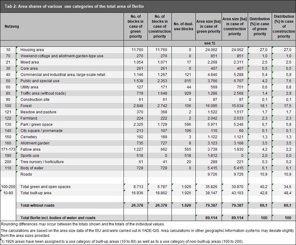
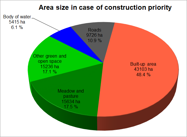
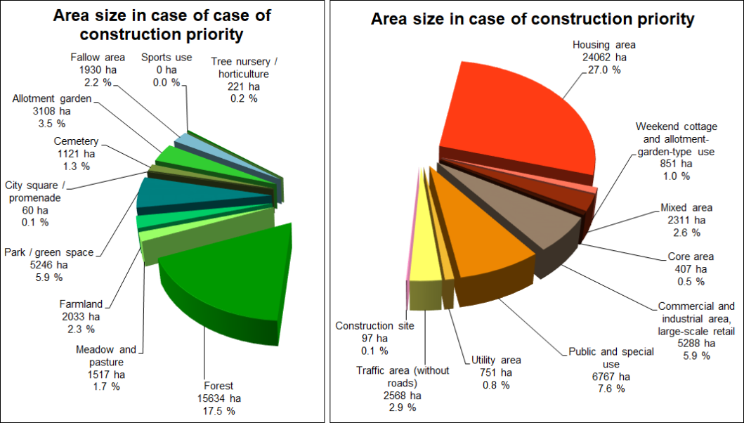
Use Distribution for Berlin

The following tables and figures show the shares of all use types in relation to the total area of Berlin. It should be noted that 1,926 areas have both a land use category of built-up areas (nos. 10 through 90) and of non-built-up areas (nos. 100 through 200).

With this approach, major potential green and open space areas can be displayed on other use areas. This applies particularly to Public and special use sites, Utility areas, Commercial and industrial areas and Traffic areas. These areas are shown on both maps, i.e. differently (cf. the explanations of dual use in the Methodology section).

Since for the evaluation of area shares, each area can only be considered once, both cases– green priority and construction priority – have been calculated separately.

The calculations are based on the area size data of the ISU. The block and block segment areas were calculated using the Geographic Information System (YADE) based on the ISU5 block segment map. It should be noted here that area calculations using other geographic information systems may deviate slightly from the area sizes provided here.

Table 2 presents the area shares, both in absolute numbers and percentages, for different use categories of the total area of Berlin.

Tab. 2: Area shares of various use categories of the total area of Berlin, area sizes based on the ISU5 block (segment) area map, as of December 31, 2020

Tab. 2: Area shares of various use categories of the total area of Berlin, area sizes based on the ISU5 block (segment) area map, as of December 31, 2020

Fig. 1: Shares of various use categories of the total area of Berlin, area sizes based on the ISU5 block (segment) area map, analysis based on construction priority, as of December 31, 2020

Fig. 1 a+b: Shares of various use categories of the total area of Berlin, area sizes based on the ISU5 block (segment) area map, analysis based on construction priority, as of December 31, 2020

Fig. 2: Shares of various use categories of the inventory of green and open spaces, and of the total built-up area of Berlin, area sizes based on the ISU5 block (segment) area map, analysis based on construction priority, as of December 31, 2020

In terms of the absolute area of all Berlin boroughs [in ha], the following overview emerges:

Tab. 3: Area shares of various use categories of the total area of Berlin [in ha], area sizes based on the ISU5 block (segment) area map (in case of construction priority), as of December 31, 2020

A presentation of the distribution of use types among the boroughs in absolute terms in ha, and in relative terms in % of the area of the borough, is shown in Figures 3 and 4.

Fig. 3: Area shares of various use categories of the total area of Berlin in ha, area sizes based on the ISU5 block (segment) area map (in case of construction priority)

Fig. 3: Area shares of various use categories of the total area of Berlin in ha, area sizes based on the ISU5 block (segment) area map (in case of construction priority)

Fig. 4: Area shares of various use categories of the total area of Berlin in %, area sizes based on the ISU5 block (segment) area map (in case of construction priority), as of December 31, 2020

Fig. 4: Area shares of various use categories of the total area of Berlin in %, area sizes based on the ISU5 block (segment) area map (in case of construction priority), as of December 31, 2020

Land use distribution changes in comparison to the previous edition

A comparison with the figures of the 2015 edition reveals several pointers in how use has changed in Berlin, which allows for more general trends in urban development to be deduced. Hence, growth of 370 ha in block areas with residential use demonstrates increased residential construction activity, which may be explained predominantly by the actual developments since 2015. It is important to note here that the additional subsequent small-scale densification within a block or block segment area of the same use category is not shown at block or block segment level.

The decrease in fallow areas of approx. 706 ha (Green use 171, 172, 173) is due to two reasons. On the one hand, this reflects the land consumption of these areas for the construction of new buildings. On the other hand, during the use check and the comparison with the digital field block register, numerous previous fallow areas were assigned to the green space category. This is the case, as these areas are currently fallow but are recorded in the digital field block register and thus have the status of farmland. As a result, there is an increase in green space (plus 140 ha).

The growth of areas in the category “Weekend cottage and allotment-garden-type use” by 59 ha may be explained by rededication to large extents. Especially in the eastern boroughs, various former allotments lost their status according to the Federal Allotment Garden Law due to rededication. Hence, the increase in “Weekend cottage and allotment-garden-type use” can be explained by the decrease of 111 ha in the use category “Allotment garden”. However, two thirds of the decrease in “Allotment gardens” is based on use changes in residential and commercial areas.

The significant decline in the “Utility area” category by 143 ha is due to a change in the mapping rules and not to an actual change in use. For example, the BVG depots and the Central Bus Station (ZOB) were no longer assigned to the category “Other traffic areas” but mapped as “Utility area”.

These methodological changes mentioned, which were implemented during the use mapping of the current update, and which are not based on actual use changes, render it difficult to compare the use shares as of December 31, 2020 with those of the previous mapping of December 31, 2015. The Housing Construction Space Information System (WoFIS), which has been available for several years and was available as a data source for the first time, also allowed a more comprehensive mapping of current housing construction projects than previously possible. This complicates a direct comparison of both versions further. A tabular comparison of the two land use mappings is therefore not provided.

With regard to the development of the inventory of green and open spaces, the Environmental Atlas map “Open-Space Development (06.03) was updated parallel to the land use mapping (SenStadtWohn 2021d). It presents the decreases and increases in green space up until August 2020 (date of the aerial photography data).

Description of Map “Actual Use of Built-Up Areas” (06.01)

The Map “Actual Use of Built-up Areas” (06.01) shows the different use categories by their shares of the built-up area of Berlin and their distribution throughout the city area (as of December 31, 2020). Figure 5 further illustrates the distribution of the construction use shares for the built-up area of each borough.

More than the half of the built-up area of Berlin is used for housing. Commercial and industrial areas and Public and special uses account for 12 % and 16 %, respectively – a relatively large share of the built-up area of Berlin. They are followed by Traffic areas, excluding roadways that are not part of the block (segment) map, with 6 %, followed by Mixed-use areas, with approx. 5 %. For Berlin as a whole, Core areas, Utility areas, Weekend cottage and allotment garden-type use areas take up very little space. Block (segment) areas mapped as Construction sites are included in the current map. With a total of 97 ha, they also occupy only a very small area, which is subject to constant change, however, as construction progresses and new construction sites appear.

Characteristic structures may be identified in the distribution of the use categories of built-up areas within the urban area. Thus, purely residential or commercial areas exist on the outskirts much more frequently than within the City Rail Circle Line; the Mixed and Core area use categories are more heavily represented in the latter. Compared to other metropolises, however, Berlin continues to have a remarkable proportion of areas used entirely or predominantly for residential purposes, even near the city centre. In the borough of Friedrichshain-Kreuzberg, for example, the share of blocks and block segments with residential use is more than 40 % of the built-up area, while it drops to more than 30 % in Mitte, mainly due to other uses in the borough.

Commercial areas are particularly concentrated along waterways, railway lines and main roads, due to the more favourable transport conditions. One often finds Mixed areas and scattered Core areas in the old village centres in various parts of the city as a result of evolved structures and Berlin’s polycentric layout. Particularly characteristic is, however, the concentration of the Core Areas in both the western city centre around Kurfürstendamm / Tauentzienstraße, and in the eastern city centre area of Alexanderplatz / Friedrichstraße, as well as at Potsdamer Platz. Public use areas are distributed throughout the entire urban area relatively evenly. Utility areas occur mainly on the outskirts, frequently in the vicinity of commercial areas.

The described structures are also reflected in a comparison of the distribution of the land use categories within the boroughs (cf. Fig. 5).

Fig. 5: Shares of selected use categories in the built-up areas of all Berlin boroughs, area sizes based on the ISU5 block (segment) map (for areas with dual use, i.e. green space and construction use, the latter was taken into account – construction priority), as of December 31, 2020

Fig. 5: Shares of selected use categories in the built-up areas of all Berlin boroughs, area sizes based on the ISU5 block (segment) map (for areas with dual use, i.e. green space and construction use, the latter was taken into account – construction priority), as of December 31, 2020

Examples for the characteristic use distribution on the outskirts are the boroughs of Marzahn-Hellersdorf and Neukölln, with 67 % and 66 % residential use and 12 % and 11 % industrial / commercial use, respectively, while in the borough of Mitte, the borough’s central functions are reflected by its shares of only 35 % Housing area, but more than 5 % Core area use and approx. 13 % Mixed area use, as well as a high share of Public use facilities (30 %).

As the Core area use around Kurfürstendamm, Breitscheidplatz and Tauentzienstrasse is distributed across three boroughs in the western city centre – Charlottenburg-Wilmersdorf, Schöneberg-Tempelhof and Mitte – the primary function of this area is less clearly reflected in the distribution of uses in the first two boroughs (Core area shares of up to 2%).

Besides the borough of Mitte, the inner city boroughs of Friedrichshain-Kreuzberg and Charlottenburg-Wilmersdorf have relatively low shares of purely residential or primarily residential blocks, with 45 % and 48 % respectively. Mixed areas are characterised by a varying share of residential space that fluctuates greatly locally. This coexistence of housing, commerce and manufacturing, also known as the ‘Berlin mix’, remains most apparent in the boroughs of Mitte and Friedrichshain-Kreuzberg. They are the boroughs with by far the largest shares of Mixed use (13 % and 16 %).

With the lowest share of commercial use (5%) in the entire city, Zehlendorf-Steglitz stands out as a residential borough with a share of 66 % of residential use.

Description of Map “Inventory of Green and Open Spaces” (06.02)

The Map “Inventory of Green and Open Spaces” (06.02), shows the different use categories and their shares of Berlin’s non-built-up areas and how they are distributed across the city.

The largest share of the Inventory of Green and Open Spaces is located on the outskirts of the city, including particularly the large wooded areas of the Grunewald and Düppel forests in the southwest, the Spandau and Tegel forests in the northwest, and the large forest areas in the borough of Köpenick in the southeast of Berlin. Forests account for 38 % of all Green and open spaces. Bodies of water account for 13 % (cf. Fig. 6).

Areas used for agricultural purposes, which account for almost 9 % of the inventory of open space, are found particularly in the north-eastern area (Pankow and Weißensee). Other agricultural areas are located on the remaining outskirts. Allotment gardens, which account for some 8 % of the open space inventory, are found almost exclusively outside the City Rail Circle Line, albeit still in the vicinity of the city centre in some cases. Often, they are located near canals, rivers and railway lines. The currently unused fallow areas are distributed throughout the entire urban area, particularly along railway lines and bodies of water. They account for some 9 % of the total open space. The few remaining Tree nurseries and horticultural areas are found predominantly on the outskirts, while areas of the categories Sports use, Cemetery, and Park and green space are located throughout the entire urban area.

The area size of the open spaces increases as one moves from the inner city area toward the outskirts. Moreover, in the outer areas of the city, the various categories of open space are often located adjacent to one another, and thus form larger contiguous open systems, while the various open areas in the inner city usually occur in isolation, and are surrounded by built-up areas. In the inner-city boroughs, the inventory of open space is dominated by parks.

Fig. 6: Shares of selected use categories of green and open spaces in the Berlin boroughs, area sizes based on the ISU5 block (segment) area map (for areas with dual use, i.e. green space and construction use, the first was taken into account – green priority), as of December 31, 2020

Fig. 6: Shares of selected use categories of green and open spaces in the Berlin boroughs, area sizes based on the ISU5 block (segment) area map (for areas with dual use, i.e. green space and construction use, the first was taken into account – green priority), as of December 31, 2020