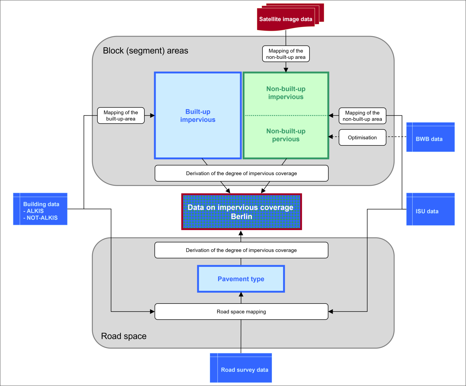
The analysis process of the block (segment) areas was based on the use of ALKIS and additional building data for impervious built-up areas, and on the analysis of high-resolution multi-spectral satellite-image data for the impervious non-built-up areas (cf. Figure 2).
A Sentinel-2A scene recorded on June 7, 2021 was employed. Relevant information from the Environmental Atlas, the Urban and Environmental Information System (ISU), and the already ascertained corrective factors, which were developed based on the data of the Berlin Waterworks (BWB data), were incorporated into the classification process. The mapping process is divided into three stages of analysis:
- Mapping of built-up impervious areas,
- Mapping of non-built-up impervious areas,
- Derivation of the degree of impervious coverage.
A detailed description of the methodological approach may be found in the final report on the impervious soil coverage mapping of 2021 (only in German).
The built-up impervious areas contained in the 2021 dataset were defined based on two data bases. This involved, on the one hand, the use of ALKIS building data. As it is incomplete, especially regarding allotments and newly built-up areas, NOT-ALKIS data was used in addition on the other hand (cf. Statistical Base). Integrating building data into the mapping process constituted the first component of the hybrid method approach. These areas were therefore not analysed with reference to the satellite-image data.
A classification approach was used for the mapping of the non-built-up impervious areas, in which satellite-image data (Sentinel-2A) and geo-data (building data, ISU) were used and combined with each other.
The evaluation of the satellite image focuses on the following evaluation criteria.
Categorisation of Area Types Relevant for Remote Sensing
To improve the mapping results, the ISU area types were categorised according to criteria relevant for remote sensing, i.e. building height, vegetation height, reflective properties, heterogeneity and relief, as well as the average degree of impervious coverage of the existing data stock (2001). Eighteen categories were defined. This permitted spatially separated sub-classifications with an optimised methodological choice in each case.
Spectral Classification of Non-Built-Up Areas
The data collected by the satellite’s sensor was further processed with the aid of an automatic classification system. First, the degree of vegetation of the non-built-up areas was calculated using the Normalised Difference Vegetation Index (NDVI) per pixel of 2.5 × 2.5 m².
This index is based on the fact that healthy vegetation reflects relatively little radiation in the visible spectral range (wavelengths of approx. 400 to 700 nm) and much more, relatively, in the near infrared range (wavelength from about 700 to 1300 nm). Normalisation results in a range of values between -1 and +1, with positive values close to 1 indicating “many healthy, photosynthetically active plants per area” (e.g. Hildebrandt 1996).
The degrees of impervious coverage are obtained step-by-step from the degrees of vegetation pixel by pixel. The method is based on the following assumptions:
- There is a linear connection between NDVI and the degree of vegetation: the higher the NDVI, the more (vital) vegetation is present.
- There is a high negative correlation between the degree of vegetation and the degree of impervious coverage.
Vegetation-free areas (degree of vegetation: 0 %) are reflected by low to very low index values. More detailed distinctions between impervious and pervious sections are not possible via NDVI.
Areas completely covered by healthy vegetation (degree of vegetation: 100 %), such as forests or grasslands are largely reflected by high to very high indices. These areas were classified as pervious.
The problem of local obscuring by treetops of impervious areas cannot be solved based on the evaluation of satellite-image data with its top view. To correct for this “error”, context-related correction factors were ascertained and implemented, with the aid of ISU data. Detecting and distinguishing between graduations of the degree of vegetation (degree of vegetation: >0 % and 0 %). They were assigned to different degrees of impervious coverage in the rule-based classification system, depending on the area type or area-type category.
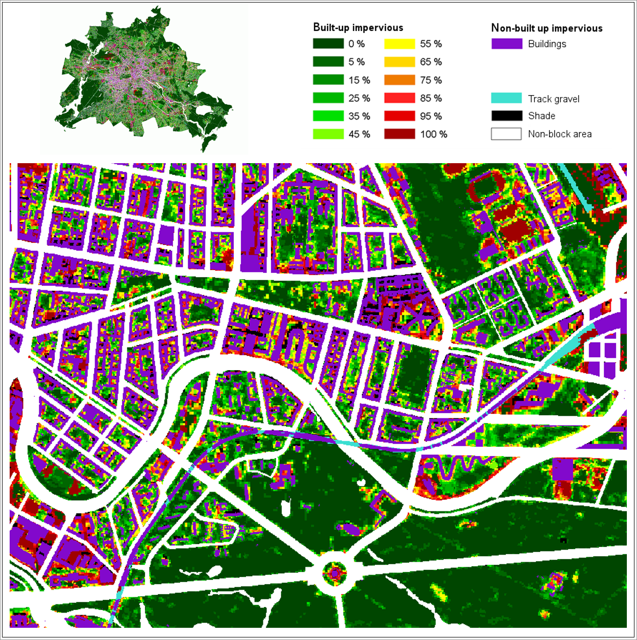
Based on this approach, 12 NDVI categories were established.
Drawing on the impervious coverage data, it should be possible to evaluate *track grave*l flexibly. In some contexts, these areas are considered impervious, in other contexts, they are considered to rather fall into the pervious area category. Therefore, “track gravel” was classed separately in the “railyard” category.
Due to their reflective properties, surface materials such as sand, ash and tamped soil as well as artificial surfaces were further separated into mappings based on objects. This step was taken to ensure a more targeted consideration of their impervious properties in the evaluation process and to minimise mapping errors.
The classification components were merged into a pixel-based data set, which formed the basis for the subsequent rule-based classification. Areas mapped as sand, ash or tamped soil, artificial surface or track gravel were aggregated with the impervious built-up building areas to form a classified combined block area.
The “Shade” class remained separated from the other classes and was addressed further when calculating the degrees of impervious coverage.
Rule-Based Classification
In the rule-based classification, the results of spectral classification were combined with ISU data (area types) to yield degrees of impervious coverage derived by pixel. For this purpose, an existing set of rules was initially repeated and applied as is, and a preliminary mapping was carried out for 2021.
In order to improve the comparability of two rule-based classifications derived using a mono-temporal approach, a second step was carried out involving a multi-temporal change analysis of satellite image data between 2016 and 2021.
The new rule-based classification of 2021 and the previous one of 2016 were thus available as an intermediate result. The objective was to obtain reliable information on changes in the degree of impervious coverage at block or block-segment level by linking these mappings with each other and with the current ISU5 of 2020.
Methodologically, the following aspects had to be taken into account in this process:
- Recording of changed areas and automated elimination of pseudo-changes by means of multi-temporal change mapping,
- Comparability of the blocks in terms of geometry and area type category.
For the reliable recording of suspected areas, indicating a change in impervious coverage, the existing satellite image data of 2016 and 2021 was analysed for the non-built-up areas on the one hand. For this purpose, relevant NDVI channels were compared with each other following normalisation and suspected areas were derived that indicate changes in impervious coverage. On the other hand, the building data was examined with regard to possible changes within the built-up impervious areas.
Another set of rules taken from the rule-based classification of 2016 and the intermediate result of 2021 were used to derive the final rule-based classification of 2021. For unchanged block (segment) areas, the 2016 classification was retained. The rule-based classification of 2021 was adopted in the following cases:
- Changed block (segment) areas (changes of the ISU area type, or major changes of block geometry),
- Suspected areas within unchanged block (segment) areas (changes in spectral properties, taking into account the phenology),
- Previously built-up areas, which, according to the current ALKIS building stock, no longer contain any structures (demolition).
The final result of the rule-based classification system of 2021 for the non-built-up area was also the final result of the satellite-image classification process. The category “non-built-up impervious area” has been described in the classification with the 12 categories of the degree of impervious coverage, a Shade class and a Track-gravel class (cf. Figure 3).
Figure 3 shows the 12 categories representing the degree of impervious coverage, the Shade and Track-gravel classes, and the built-up impervious areas from building data on a grid basis. Drawing on this intermediate result (grid data), the mean degrees of impervious coverage were then calculated by block area (cf. Calculation of the Degrees of Impervious Coverage). After final plausibility checks, any distinct pseudo changes were located, and relevant blocks were excluded from further analysis.