Water Conservation Districts and Groundwater Use 1995

Introduction

The drinking water needs of Berlin are met primarily by groundwater. The drinking water supply is managed by the Berlin Public Water Companies. Water supplies are partially obtained as bank filtered water: surface waters filter through the soil and are withdrawn by extraction wells near the banks). Some surface water are diverted into groundwater recharge plants to percolate into groundwater, which will then be withdrawn for use.

Fig. 1: Principles of Groundwater Production

Fig. 1: Principles of Groundwater Production

There is also a number of smaller production plants, the private sector water supply plants, which withdraw groundwater for private sector purposes, mostly industrial, or withdraw groundwater for public facilities.

Construction increased considerably after the unification of Berlin in 1990. Groundwater retention is practiced during construction when groundwater is withdrawn. This occurs according to construction activity at various locations and in variable amounts. Especially deep and/or large construction projects use the trough construction method which spares groundwater. This method requires the withdrawal only of small remainders of water.

Drinking water is supplied by 12 waterworks of the Berlin Public Water Companies. Production at the Riemeisterfenn Waterwork was temporarly discontinued in March, 1995. The Berlin Public Water Companies withdraws water from 1,200 groundwater extraction wells. The waterwork wells are safeguarded as water conservation districts to protect water from pollution; certain activities and uses are forbidden in these areas.

Fig. 2: Groundwater Withdrawal Amounts in Berlin According to Use in 1995 (including Stolpe Waterwork) Statements for groundwater recharge at construction sites refer to the calendar year; statements for raw water extraction refer to the water management year Nov. 1994 to Oct. 1995.

Fig. 2: Groundwater Withdrawal Amounts in Berlin According to Use in 1995 (including Stolpe Waterwork) Statements for groundwater recharge at construction sites refer to the calendar year; statements for raw water extraction refer to the water management year Nov. 1994 to Oct. 1995.

West Berlin

There were 7 waterworks in the western part of the city in 1995. The Riemeisterfenn and Spandau Waterworks were protected by the Allied (U.S./French/British Occupation Authorities) Water Conservation Zone Ordinance of 1946. The 5 other drinking water conservation districts were determined by the Water Balance Law (Wasserhaushaltsgesetz – WHG), the Berlin Water Law (Berliner Wassergesetz – BWG) and the respective regulations for determination of water conservation districts for the waterworks in Kladow, Beelitzhof, Tiefwerder, Jungfernheide and Tegel. A regulatory draft for the Spandau drinking water conservation district exists (cf. Tab. 1).

Tab. 1: Waterworks of the Berlin Public Water Companies and Statutory Framework for Water Conservation Districts

Tab. 1: Waterworks of the Berlin Public Water Companies and Statutory Framework for Water Conservation Districts

Water conservation zones in areas regulated by Section 4 of the Magistral Ordinances of 8 October 1946 were determined use limitations. This ordinance proceeded from an order of the Allied Commandant of Berlin, valid for all Berlin. The conservation zones are divided into a narrow conservation zone with a radius of 100 m around extraction wells, and into a wider conservation zone with a radius of 500 m. The Spandau Waterwork is still protected by this ordinance. This ordinance will be replaced by a water conservation district regulation according to the Berlin Water Laws in the next few years.

Water conservation districts in the western part of the city are determined by Section 19 of the Water Balance Law (Wasserhaushaltsgesetz – WHG) or Section 22 of the Berlin Water Law (Berliner Wassergesetz -BWG). They are divided into 3 conservation zones with differing protection status; certain actions are forbidden or permissible with limitations. The borders of conservation districts and descriptions of limitations of use are defined in the regulations for each area.

The area size of the conservation zones is measured according to the DVGW Regulatory Rules “Guidelines for Drinking Water Conservation Districts” (DVGW-Regelwerk “Richtlinien für Trinkwasserschutzgebiete”). The areal extent of Zone I is generally at least 10 m surrounding the extraction well. Zone II reaches from the border of Zone I to a line at which groundwater requires 50 days to seep into the extraction well feed area. Zone III comprises the area from the outer border of Zone II and the border of the subterranean water catchment area. If the catchment area is larger than 2 km, a subdivision into Conservation Zone III A and III B is possible. Local hydrogeological conditions must be considered in the determination of conservation districts; a universal pattern may not be applied.

The rigid radius drawn around the extraction well does not take into account the differing hydrological and geological conditions in the catchment areas of the individual water withdrawal sites. The water conservation districts of Tegel and Jungfernheide were redefined on 31 August 1995. Their borders were determined by different criteria, according to the isochronic concept (cf. Fig. 3). The isochronic concept determines the size of water conservation districts and their geometric forms in hydraulic terms: from the flow time of water to the removal site. Lines of identical flow time are called isochrons. The determination of the isochrons, and thus the conservation district borders, proceed from hydrogeologic examinations of a given area. A regional groundwater flow model is developed for this area. The goal of the concept is to have sufficient time for damage control should soil (and/or groundwater) be contaminated. The determination of conservation district borders then follows under consideration of these isochrons, according to DVGW Regulatory Rules.

Fig. 3: Example for Definition of a Water Protection Area According to the Isochronic Concept The flow velocity of groundwater is indicated by the length of the arrows. The longer the arrow, the higher the flow velocity.

Fig. 3: Example for Definition of a Water Protection Area According to the Isochronic Concept The flow velocity of groundwater is indicated by the length of the arrows. The longer the arrow, the higher the flow velocity.

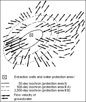
Use limitations within conservation districts were supplemented and extended in the course of revising the Water Conservation District Regulations according to the isochronic concept.

East Berlin

Water conservation districts in East Berlin were defined under GDR law. The legal basis is the Water Law of the GDR in its 3rd Implementation Ordinance (Durchführungsverordnung) of 2 July 1982 in regard to conservation and reserved areas. The East Berlin conservation districts were enacted at the 14th Berlin city council meeting on 19 October 1984.

The GDR determined reserved areas for future water supply production, where no groundwater was withdrawn. Special use limits were in force in these areas, as given in the Water Law of the GDR or in TGL 43271 of September 1984.

The border between West Berlin and the GDR was an unnatural border in the definition of water conservation districts and against the given geological and morphological conditions of the area. Conservation districts were forced to end at the political border. The new definition of drinking water conservation districts can finally resolve this problem properly.

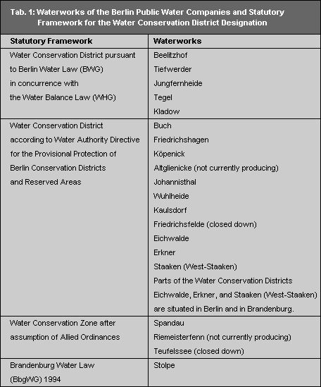
The 5 waterworks located in the eastern part of Berlin will be protected until a final new definition of water conservation districts is made according to Federal German law by 1999. This protection takes place under Berlin Water Law by a directive of the Water Authority Directive for the Provisional Protection of Berlin Conservation Districts or Reserved Areas of the Waterworks, dated 11 October 1993, latest revision 27 February 1996. Use restrictions under this directive are similar.

Water conservation districts in the surrounding areas of Berlin are defined according to GDR law. New demarcations and changes of conservation districts, as well as changes in protective status or area size are to occur after the passage of drinking water conservation district ordinances for each waterwork according to the Water Law of the State of Brandenburg. An ordinance determining the water conservation district for the Stolpe Waterwork in Brandenburg is being prepared according to the Brandenburg Water Law (Brandenburger Wassergesetz – BbgWG) of 13 July 1994.

Use Restrictions in Water Conservation Districts

Water conservation districts have protective zone categories with differentiated use restrictions.

Conservation Zone I prohibits all activities except for those measures required for water supply purposes.

Conservation Zone II prohibits:

  • the erection or alteration of constructed facilities (residential buildings, industrial facilities, streets) with the exception of alterations in buildings
  • the erection and operation of facilities for dealing with substances harmful to water and the transportation of substances harmful to water through pipelines;
  • the discharge of waste water and non-purified rain water into surface waters;
  • the use of fertilizers, insecticides, herbicides and pesticides;
  • the removal of water and solid materials from the subsoil and from openings in the earth.

Conservation Zone III prohibits:

  • the discharge of waste water into the subsoil with the exception of the spraying or seepage of rain water through the topsoil;
  • activities which enable the penetration of pollutants into surface waters, the subsoil or groundwater; in particular the dismantling and repair of motor vehicles, including the changing of oil on unstabilized soil;
  • the erection, rebuilding, extension or basic alteration of buildings, unless there is a complete and proper waste water drainage by sealed pipelines into public waste water facilities, or the collection of drainage in permanently sealed pits with proper disposal;
  • the erection and operation of dumps for waste harmful to water and/or waste disposal facilities which require planning approval;
  • the construction of gravel pits, the placement and storage of materials harmful to water directly on the subsoil, particularly for the construction of streets, canals, and paths; with the exception of small improvements with no danger of contamination;
  • the construction or extension of drains for dewatering the subsoil.

The protective regulations of Conservation Zone III apply to the narrow Conservation Zone II and for the captation area (Zone I). The protective regulations for the narrow Conservation Zone II apply to the captation area (Zone I).

The prohibitions of Conservation Zone III as well as two prohibitions of Conservation Zone II apply to the Plänterwald and Gosener Wiesen reserved areas. These areas are part of the conservation district of the Johannisthal Waterwork and/or the Friedrichshagen Waterwork.

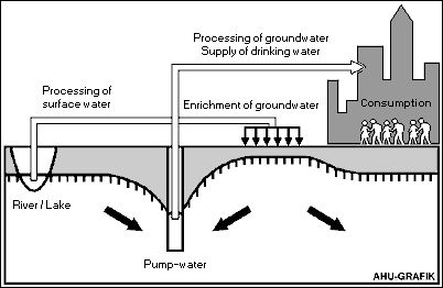
There is also a number of smaller groundwater supply facilities in the private sector, usually for industrial purposes, or commissioned by public facilities. Water is withdrawn and treated in these private sector water supply plants by users themselves. These plants are usually established and run by industrial and commercial operations, but also by public institutions such as hospitals and swimming facilities. The groundwater they withdraw is used as drinking, operating, and cooling water, and to water plants, lawns and meadows. Both the Berlin Public Water Companies, private sector water supply plants require official permits or special approval with specified use considerations and restrictions. These are mandated by the Berlin Water Balance Law or the Berlin Water Law. There are no conservation zones for private sector plants.