Building Age in Residential Development 2016

Map Description

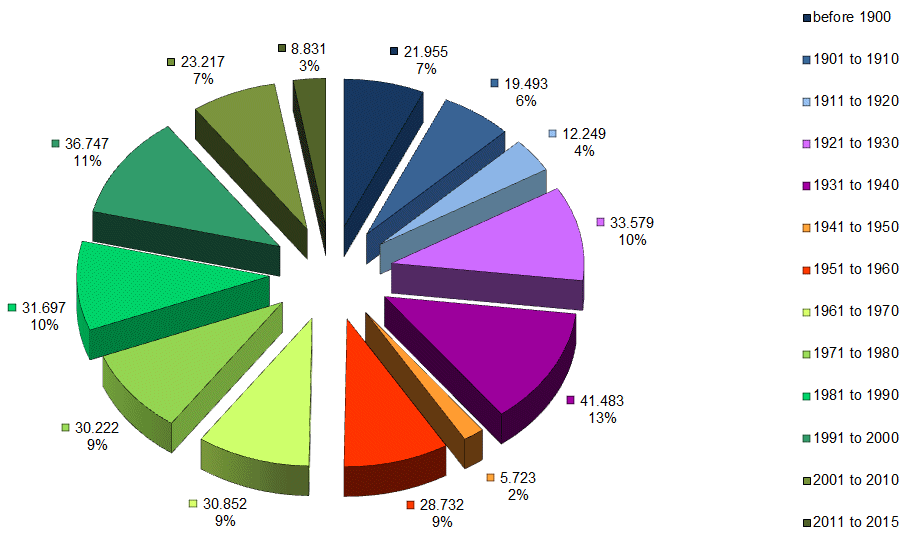
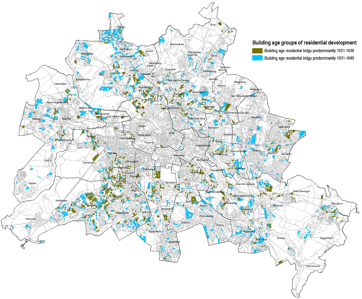
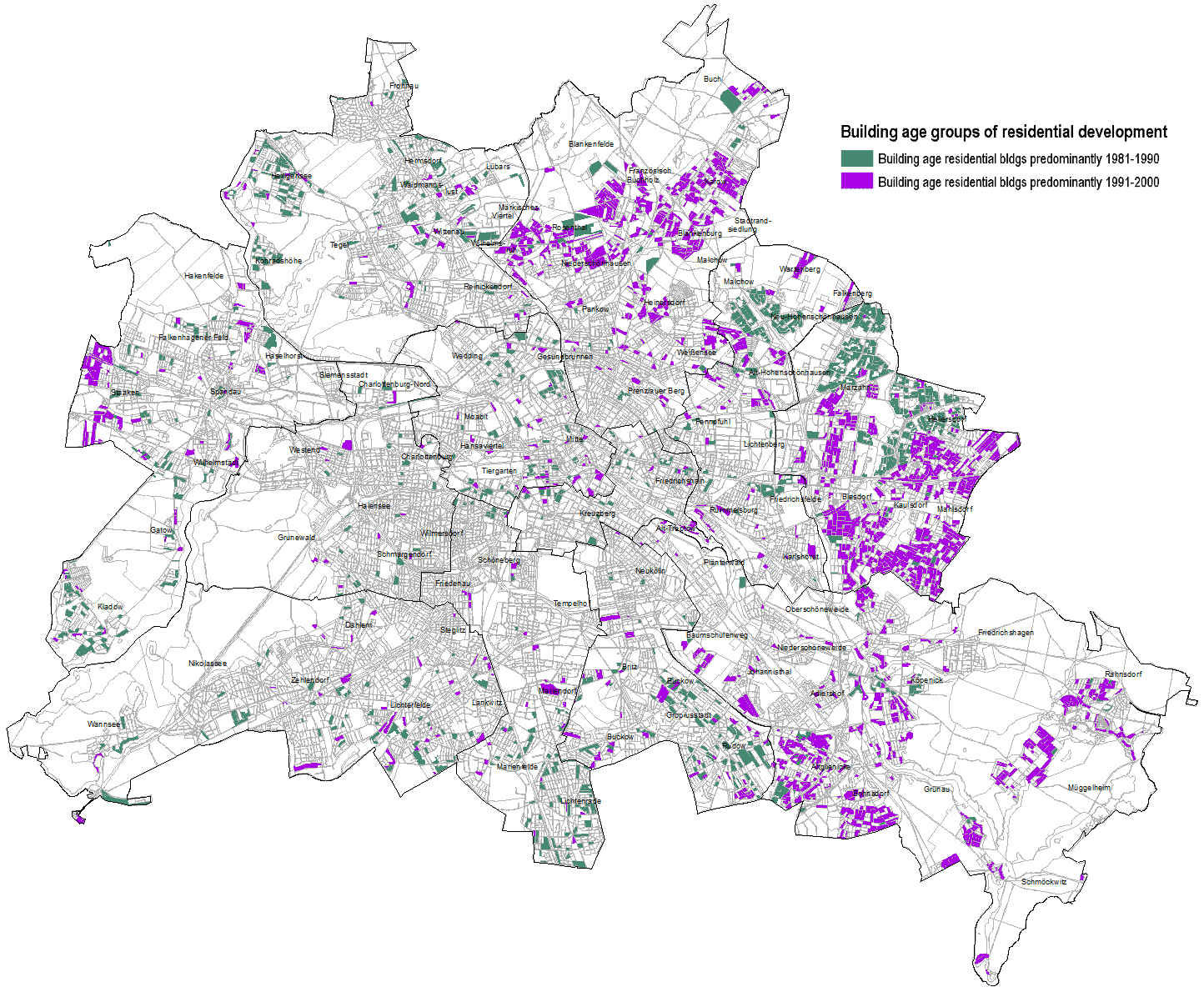
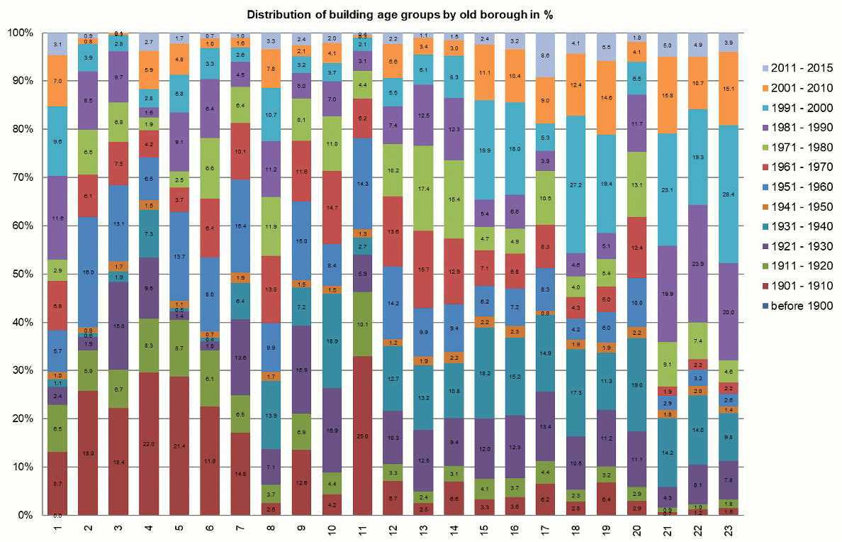
The map provides a spatial and quantitative overview of construction activity in the area of residential construction for the decades presented.

Both the expansion of the city at the beginning of the last century and the areas of more extensive residential development since the reunification and in recent years (decades from 1991) may be clearly distinguished.

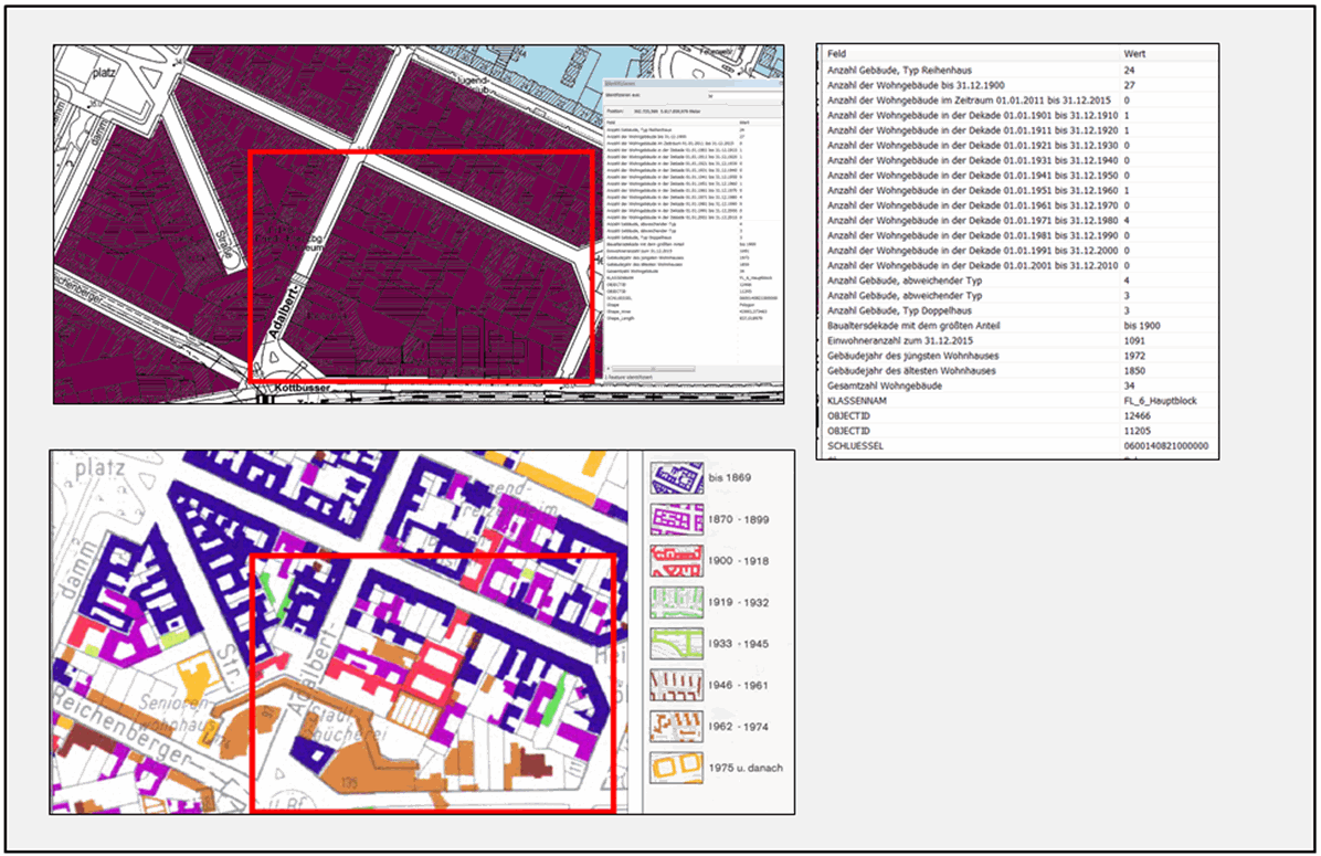
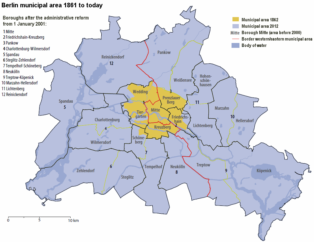
Due to the spatial focus on blocks and block segments and the representation of the predominant building age group, a generalization occurs naturally. Upon the inspection of closely limited sections, such as that of an individual block, it is possible that “fine structure” will not become visible. Focussing on the area north of “Kottbusser Tor”, the comparison of the above-mentioned record by Aust 1994 with the present map (cf. Fig. 1) shall serve as an example.

Fig. 1: Comparison of the “predominant building age group” classification per block/block segment with a building-related assignment to construction periods (top: section from Map “Building Age in Residential Development” (06.12) and bottom: section from Map “Gebäudealter 1992/1993” (Building Age 1992/1993)

Regardless of the fact that the building-related representation includes potential non-residential buildings and does thus not match the stock recorded in this Environmental Atlas map 1:1, both representations correspond in terms of the predominant building age of the buildings in the sample block. The factual data on the block map also facilitates an analysis of further building decades present in the block, as well as the year of construction of the oldest and the newest residential building. It is not possible, however, to display the distribution of these buildings within the block, as data protection reasons prevent address-based mappings.

When comparing decades with each other (cf. Fig. 2), it is important to remember that the number of buildings is the only variable in this context; even with the help of characteristics, such as “detached” or “duplex”, information on floor space, apartments built or the distinction between single-family and multi-family houses cannot be inferred.

Hence, additional data on urban structure as of 2010 can be accessed via the data display for factual data in the Geoportal.

Thus, information on area types related to the use of green and open spaces (e.g. Type 57 “fallow area” or Type 37 “allotment garden”) indicates that these areas have been built-up in the meantime with buildings recorded on the map and that they have thus seen a change in their use.

Fig. 2: Shares of building age groups of the total number of residential buildings

When comparing decades based on their share of the total number of residential buildings constructed, none of the decades stand out in particular (cf. Fig. 2).

The two decades between 1921-1940 and those between 1981-2000 do stand out slightly with a share of more than 10 % each and will be described in more detail in the following.

1921-1940 building age groups

The formation of “Greater Berlin” in the year 1920 involved the aggregation of Berlin with 7 other cities, 59 rural communities and 27 estate districts. The population doubled from 1.9 million to 3.8 million inhabitants (SenStadtUm 1994). Facing a severe housing shortage, Berlin experienced an all-out residential construction, which also led to the development of the six housing estates of “Berlin Modernism” (e.g. the “Hufeisensiedlung” (“Horseshoe” housing estate) in Britz and the large housing estate Siemensstadt (only in German)) that are part of the UNESCO World Heritage today. Figure 3 illustrates the number and the spatial distribution of blocks and block segments, which were formed by residential development during this period. While the actual inner city, i.e. the area within the former tariff wall as well as within the so-called “Wilhelminischer Ring” between the former tariff wall and the City Rail Circle Line, had already been built-up in previous decades, residential development now focussed on areas adjacent to those newly incorporated into Berlin. The outskirts remained predominantly undeveloped, bar some exceptions, such as Garden City Frohnau.

Fig. 3: Distribution of blocks and block segments mainly from residential development building age groups for the decades 1921-1930 and 1931-1940

1981-2000 building age groups

In the former western part of the city, the construction phase of the 1980s up until the fall of the Berlin Wall considered the existing stock much more strongly, replacing the phase of large-scale reconstruction in the inner-city area. The International Building Exhibition (IBA) was founded in 1979 for demonstrative purposes predominantly concerning Kreuzberg. The impact of their second approach of “gentle urban renewal” for the building stock is not spatially represented on this map, as existing buildings were renovated rather than new buildings being constructed. The results of the IBA’s “New Building” component are evident in the area “Am Tegeler Hafen” in Reinickendorf and predominantly in Kreuzberg in blocks of southern Friedrichstadt (cf. Fig. 4). In general, the largest share of residential development consisting of new estates increasingly shifted towards the outskirts of the city; the large estates Marzahn and Hellersdorf, which were built in several stages in the 70s and 80s, shape the eastern part of the city in particular. The West Berlin counterparts “Märkisches Viertel” and “Gropiusstadt” had already been completed in the preceding decades up until the mid-1970s.

Just after the fall of the Wall, large-scale residential development focussed on previously undeveloped open spaces in the former eastern part of the city, including Karow / Blankenburg / Französisch Buchholz, where new estates were developed in the form of low detached or duplex homes with gardens. In addition to closing building gaps on a larger scale, new buildings were added to plots that had been divided in areas with detached homes on large plots, mainly focussing on Biesdorf / Kaulsdorf / Mahlsdorf.

Fig. 4: Distribution of blocks and block segments mainly from residential development building age groups for the decades 1981-1990 and 1991-2000

1911-1920 and 1931-1940 building age groups

The decades 1911-1920 and 1941-1950 clearly show the lowest values; with the two world wars particularly causing the decrease in building activity (cf. Fig. 2). Incidentally, Garden City Frohnau (only in German) was inaugurated on 7 May 1910 already; however, only a few houses were erected in the short period of time prior to the outbreak of the First World War. The main part was only built between the two world wars. After the Second World War, reconstruction programmes for West and East Berlin were only put into place in the 1950s after the way had been paved by the Marshall Plan in West Berlin and the “Aufbaugesetz” (Reconstruction Act) in the GDR.

Distribution of building age groups according to boroughs

Berlin’s changing administrative structure at borough level is closely linked to the founding of Greater Berlin in 1920 and the political developments and changes exerting their influence in the subsequent decades. Until the administrative reform of the boroughs in 2001, the 23 boroughs were divided into those forming the urban core (Mitte, Tiergarten, Wedding, Prenzlauer Berg, Friedrichshain, Kreuzberg) and those that partially extended to the city limits. Figure 5 illustrates this geographic frame of reference, which largely corresponds with the structural development of the city. With the administrative reform of 2001 and the formation of twelve aggregated boroughs, some of which with a population just short of 400,000 inhabitants, this link to urban development lost its distinctiveness, with the borough Mitte being the exception, as almost all remaining boroughs now comprise both inner-city areas and the outskirts.

Fig. 5: Berlin municipal area 1861 to today, borough structure before and after the 2001 administrative reform

The analysis of the distribution of building age groups across the boroughs was thus based on the structure of the area before merging the boroughs (cf. Fig. 6). A clear connection can be made between the location of the borough within the municipal area and the distribution of building age groups according to boroughs:

  • The core boroughs display a high proportion of old building stock in their residential development (building completion up to 1920; e.g. Mitte 48.2 %, Tiergarten 54.1 %, Kreuzberg 65.7 %).
  • The reconstruction (1951-1960) phase accounts for a relevant share of 10 % on average in inner city boroughs, due to massive destruction during the war.
  • Facing an increasing scarcity of land in the inner-city area, the new construction activity in residential development was pushed further and further towards the outskirts of the city in subsequent decades. The large settlements Marzahn (from 1977 (Borough Office Marzahn-Hellersdorf n.d.)) and Hellersdorf from 1981 (cf. here, only in German) were built in the eastern part of the city, mainly on sewage farms previously used for agricultural purposes. The extent of these and later construction projects, which are reflected in the total building stock of the two boroughs, are illustrated by the building age group shares (1981 et seq.): 67.4 % of the building stock in Hellersdorf and 63.8 % in Marzahn was constructed after 1981 (cf. also Fig. 4). Western large estates had an impact of similar magnitude on the building stock of their borough during their time of origin: the construction period of the large settlement “Märkisches Viertel” (1961-1980) accounts for approx. 25.5 % in Reinickendorf and that of Gropiusstadt for a comparable 28.3 % within the same period. In the years following reunification, however, construction activity in residential development was considerably lower here than in the boroughs of the former eastern part of the city.

Fig. 6: Distribution of building age groups by old borough in %

h6. Berlin’s structure prior to the administrative reform was used here to illustrate the distribution, as it distinguishes spatially more clearly between the inner and outer city and is therefore better suited for an urban representation. On 01/01/2001, what had been 23 boroughs since 1990 were merged into 12 boroughs.