Soil Types – Horizons
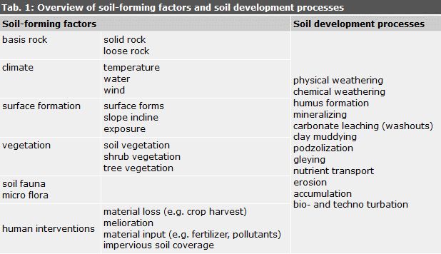
Soil types are considered stages of soil development often encountered under certain environmental conditions. They unify soils with the same or similar profile structures (horizon layers), due to similar processes of material transformations and translocations.
The most frequent soil types in Berlin are mineral soils with less than 30 percent by mass of organic substances. These soils are sometimes overlaid with organic horizons of varying thickness; H, L, or O horizons with more than 30 percent by mass of organic substances, especially in forests.
Soil types of mineral soils are categorized into the following horizons:
mineral topsoil horizon – A horizon
mineral subsoil horizon – B horizon
mineral undersoil horizon – C horizon
The mineral topsoil A horizon is characterized by the accumulation of organic substances and/or a loss of mineral substance; washouts of clay, humic materials, iron oxides and aluminum oxides. Material-specific accumulation and translocation processes enable further divisions of the A horizon. This differentiation in horizon terminology is indicated by a trailing lower-case letter; e.g., Ah, h stands for humus; Al, l stands for clay lessivation (washout).
The mineral subsoil B horizon is characterized by the accumulation of materials washed out of the topsoil horizon, as well as weathering and transformational processes, e.g., brunification, formation of clay, etc. This produces colours and material compositions different from that of the basis rock. Further differentiation of the B horizon parallels the A horizon, e.g. the v in Bv stands for weathered, brunified, clayey; whereas the t in Bt stands for accumulated clay.
The mineral undersoil C horizon is formed by the relatively unaltered basis rock underneath the soil.
The soil profile of soils characterized by several material translocational or transformational processes thus features several A and/ or B horizons layered on one another.
The horizon sequence indicates the horizon profile. The horizon profile is then used to differentiate soils into soil types.
Another factor in the formation of soil types is the influence of the groundwater level. The temporary or permanent effect of groundwater on soils affects how terrestrial and semiterrestrial soils form gley characteristics, e.g. rust and bleached spots. The depth of gley characteristics is applied in the naming of soil types, such as cambisols (brown soils):
< 40 cm – dystric gleysol (brown gley soil)
40 – 80 cm – eutro-gleyic cambisol (gleyic brown soil)
80 – 130 cm – stagno-gleyed cambisol (gleyed brown soil).
Anthropogenic Alterations of the Soil
Anthropogenic alterations of the soil are increasing with progressing use of technologies and the use of ever larger areas.
Nowadays, there are hardly any untouched soils with horizon structures unaltered by humans. Soils are categorized as near-natural where horizon sequences remain largely unchanged in spite of influences by human use such as is the case with forest plantations, predominantly. Soils are categorized as anthrosols (anthric, anthropogenic soils, soils influenced by humans) when the horizon sequence has been destroyed. It has proven extremely challenging to categorize soils into these two groups, due to the difficulty in identifying the exact transition point to anthropogenic influences. The upper 20-30 cm of soils used for agriculture are usually mixed by plowing. Soils used for military training or for cemeteries can retain near-natural soils which can alternate with highly anthropogenic soils within small areas. The degree of anthropogenic influence and/or the degree of destruction is difficult to estimate without appropriate soil studies. The effect use has on the soil is also
influenced by whether the whole area was used or not.
A developmental point of view sees soils as relatively “young” or “old”. Soils relatively unaffected by use have a developmental period of up to several thousand years. The primary development of soils in the young moraine area around Berlin occurred in the Holocene period, which began about 12,000 years ago. A favourable climate, and the quick spread of vegetation connected with it, caused a stronger formation of soils. Various soil-forming processes took place during the long developmental period, and these processes are reflected in the formation of typical horizons. The horizon sequences of these soil types are thus much more greatly differentiated than those of “younger” soils.
Soil does not reproduce and is not reproducible. The use of soil is often linked with alterations of the original ecological conditions and this can lead to serious endangerment to the functional abilities of soil or even to its existence.
The quantity of soil as a natural resource is endangered by the progressive impervious coverage of soils. Industrial, commercial, traffic, and residential uses of soil are increasing more and more. Pervious soils once used agriculturally are found at the edge of the city; these soils have largely near-natural properties. Building construction caused soils to be translocated, mixed, made impervious over extensive areas and destroyed.
The quality of soils is altered by pollutants. Soils are permanently damaged by pollutant inputs from unregulated waste disposal, accidents, spills and leakages, improperly conducted storage depots, as well as emissions from industry, commerce, and traffic.
Pollutant inputs can directly and indirectly endanger all organisms, including humans. The primary danger is uptake of pollutants through the food chain, but attention must also be given to the direct oral uptake of soils, especially by small children.
Soil can only store and filter a certain amount of pollutants. If soil storage and filter capacities are exceeded, pollutants can pass through soils and enter the groundwater.
These “area use” problems are more intense in metropolitan areas like Berlin based on e.g. the quantitative problem of impervious coverage, and the qualitative problem of material loads on soils from old contaminated sites and other pollutant inputs.
The protection of the remaining near-natural soils is urgently necessary because soil does not reproduce; it cannot be manufactured, bred or grown. Strongly impaired soils can hardly ever be restored to their original quality.
Soil Protection
The discussion and considerations on soil protection at federal and state government levels in West Germany first really got underway at the beginning of the 1980s. Soil protection was first anchored in law in the Federal Soil Protection Act of 1998. This law was supplemented by a Berlin law in 2004.
The goal of the Berlin Soil Protection Act is “to protect the soil as the basis of life for humans, animals, and plants; to avert damaging alterations and to take precautions against the origin of new ones”. Long-term effects to soil are to be avoided, and the natural functions of soil are to be protected.
A prerequisite for effective soil protection is knowledge about the spatial condition of soils, as well as impairments in their quantity and quality. In some cases, information on soil use, degree of impervious coverage and material load has been compiled in Berlin for decades. This information forms the basis for assessing the anthropogenic load on soils. A cadastre of impacts on soil was developed, and a Map of Degrees of Impervious Coverage, and a Map of Use were prepared.
To plan soil protection measures and to consider soil protection concerns at individual planning levels, it is necessary to determine soil value, suitability, and sensitivity. Complete data about distribution of soils and their ecological characteristics must be available. The Map of Soils may be used to derive ecological parameters in order to assess soil properties and functions.