Exceptionally heavy or prolonged rainfall, along with snowmelt, can lead to floods, which are natural events that cannot be prevented. The rise in residential development and the increase in economic assets in flood-prone regions, coupled with the diminished capacity of the natural environment, particularly soil, to retain water due to intensive land use, has heightened the negative impacts of floods.
There is no absolute protection against floods. In order to sustainably reduce or prevent flood damage, comprehensive flood risk management is essential. This responsibility is shared by society and involves various aspects, including prevention, protection, precaution, and restoration/ regeneration. The key to limiting flood damage is a combination of governmental precautions and individual responsibility. Anyone who might be affected by floods must, to the best of their ability and within reason, take appropriate steps to protect against adverse flood effects and to reduce potential damage. This especially includes adapting how land is used to minimise the harmful effects of floods on people, the environment, and property (translated from Section 5(2) of the Federal Water Act (Wasserhaushaltsgesetz, WHG)).
According to Section 72 of the WHG, a flood is defined as the ‘(…) temporary covering of land not normally covered by water, particularly by surface waters (…). This excludes flooding caused by sewerage systems.’ (translated from the WHG). Floods can also be caused by heavy rainfall, however. A technical distinction is therefore made between urban flooding (pluvial flooding) and river flooding (fluvial events). Urban flooding occurs when heavy rainfall leads to a rapid accumulation of water in urban areas, exceeding the capacity of the canal system and drainage infrastructure. This type of flooding mainly affects urban areas where extensive impervious soil coverage (cf. Environmental Atlas Map 01.02) hinders the natural percolation of water. River flooding occurs when rivers are overwhelmed by prolonged rainfall, heavy rain events, or snowmelt, and overflow their banks as a result.
The heavy rainfall information map highlights the risk of urban flooding across Berlin and serves as an initial guide for hazard assessment. Additionally, a detailed heavy rainfall hazard map is available for specific areas, accurately depicting depths and flow velocities of urban flooding under various heavy rainfall scenarios. A detailed description of heavy rainfall and urban flooding hazards may be found in the Environmental Atlas.
The Directive 2007/60/EC of the European Parliament and the Council on the assessment and management of flood risks (FRMD) was adopted on 23 October 2007. It has been in effect since 26 November 2007 and stipulates the process for managing flood risks. The second cycle of implementing the FRMD Directive was completed at the end of 2021 with the release of the flood risk management plan (FRM Plan 2021). The third cycle is set to be implemented by 2027. In the first phase of this cyclical process, the assessment of flood risk and risk areas in Berlin is reviewed according to Section 73 of the WHG. This phase will conclude with the publication of the review by 22 December 2024 (SenMVKU 2024). The second phase to implement the FRMD involves preparing flood hazard maps and flood risk maps. These form the basis for the subsequent update to the Flood Risk Management Plan to be completed by the end of 2027. The FRM Plan includes measures that not only focus on improving flood protection but also on enhancing precautions and reducing flood risks along the Elbe River (FRM Plan 2021).
Flood hazard maps focus on river flooding, illustrating their spatial extent and water depth under three different scenarios. These hazard maps show flooding caused by a water body overflowing its banks. They do not account for other types of flooding, such as those caused by overwhelmed sewerage systems, surfacing groundwater, failing water control structures or urban flooding from heavy rainfall. Flood risk maps provide information on the potential negative effects of these flood events in relation to the areas of concern defined in the European FRMD (LAWA 2018).
Pursuant to Section 74(1) of the WHG, the relevant authority of the State of Berlin prepares the flood hazard and flood risk maps. According to Section 74(2) to (4) of the WHG, the contents of the maps must comply with the requirements of Article 6(5) of the FRMD. In order to produce maps that are largely uniform in terms of content and design, the German Working Group on Water Issues of the Federal States and the Federal Government (LAWA) has published ‘Recommendations for the establishment of flood hazard maps and flood risk maps’ (LAWA 2018) for this purpose. They contain standardised minimum requirements defined in the FRMD applicable both to flood hazard and flood risk maps.
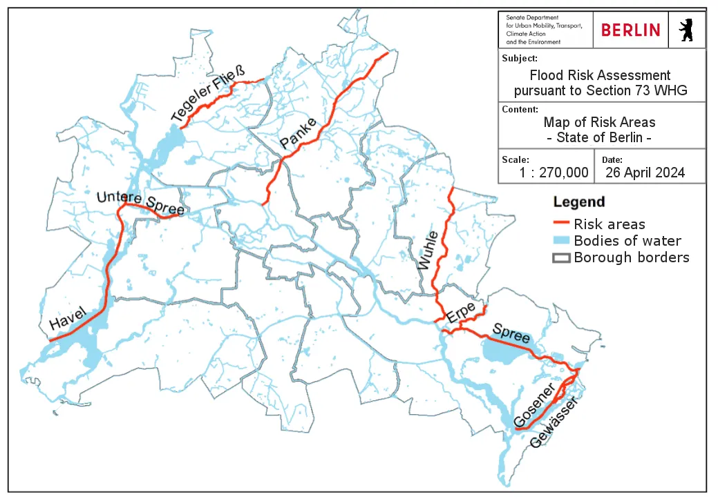
In Berlin, flood hazard maps and flood risk maps are regularly reviewed and updated as needed, following the LAWA recommendations for map creation and relevant criteria (LAWA 2017, 2018) as well as the implementation concept of the River Basin Community Elbe (FGG 2018). For a more detailed description of the methodology and the steps involved, please refer to the two documents, LAWA 2018, and FGG 2018. This process also involves close communication between the states of Berlin and Brandenburg, as they share a common border. A flood risk assessment, carried out in line with the FRMD revealed that there is a significant potential flood risk in the following areas: Tegeler Fließ, Panke, Erpe, Wuhle, Lower Havel/ Lower Spree and Müggelspree as well as the Gosener Gewässer including the Seddinsee. These regions were therefore defined as risk areas in accordance with Section 73 of the WHG (cf. Figure 1). Flood hazard maps and flood risk maps for these areas are being developed or updated and will be published by 22 December 2025.
Flood areas are identified in regions (risk areas) where there is a significant risk of flooding.
Flood areas, as defined in Section 76(1) of the WHG, are areas that are covered by water during a flood event or used for retaining floodwaters. In legal terms, a flood area is one that, statistically, is subject to flooding once every 100 years. In Berlin, flood areas are based on flood hazard maps developed for floods with a medium probability. Flood areas along high-risk bodies of water are legally designated or provisionally secured through official regulations. A comprehensive set of obligations applies here, which includes measures such as preserving and restoring retention areas, prohibiting the conversion of grassland to farmland, and imposing restrictions on construction projects. According to the Building Code (Baugesetzbuch, BauGB), establishing new building areas on the outskirts through land-use plans or other ordinances in legally designated flood areas is prohibited. To minimise the damage potential, the building of new structures or the expansion of existing ones is also prohibited under Sections 30, 33, 34, and 35 of the BauGB. Additionally, the introduction or storage of water-hazarduous substances on the ground are not permissible. Further, the long-term storage of objects that could obstruct water flow or be swept away is prohibited. In flood areas and areas subject to flood hazards, land use must therefore be adjusted to reduce flood damage and mitigate the loss of water retention capacity.
Risk areas outside designated flood areas (Section 78b WHG) provide the spatial context for the flood hazard map for low-probability floods and extreme flood scenarios, excluding any land that has been legally designated or provisionally secured as flood areas. These areas may therefore experience flooding but are expected to do so less frequently than once every 100 years.
The flood hazard maps, flood risk maps and designated flood areas serve as preventative tools for flood protection in Berlin, outlining the extent of river flooding and its effects during specific flood events. The flood hazard maps and designated flood areas also aim to raise awareness of potential flood risks.