Ascertainment of the Number of Storeys in Buildings
The ascertainment of the number of storeys in the buildings was carried out by entering the number of storeys in the Automated Property Map of Berlin (ALK).
For buildings for which the number of storeys has not been entered, an estimated value was used to calculate the floor space index: 2 for ruins, and 8 for towers.
Ascertainment of the Land to Building Ratio
The land to building ratio (LBR) states the built-up proportion of a lot. The LBR is a decimal number with one or two fractional digits. Thus, the formula for the calculation of the LBR for the preparation of the present map is derived as follows: The sum of all built-up areas on a lot – here, the block area – is divided by the total area.
Since in rare cases the areas of buildings do not agree with the block area boundaries, only the shares of those built-up areas have in those cases been compiled which were actually within the block area boundaries. This was accomplished by overlaying the building boundaries (ISU5) from the Automated Property Map (ALK) onto the block areas of the Block Map, 1:5,000. The building parts outside the block areas, e.g. on traffic areas (street land), were then not taken into account.
Ascertainment of the Floor Space Index
The floor space index (FSI) states the number of square metres of floor area per square metre of lot area, compiled at the level of the total block area.
For the ascertainment of the FSI, the following applies:
The sum of all floor spaces of the buildings or building parts located on a block area is divided by the block size. The floor area of a building is thus calculated from the sum of the area of all full floors. Generally, this means: number of full floors multiplied by the base area of the building.
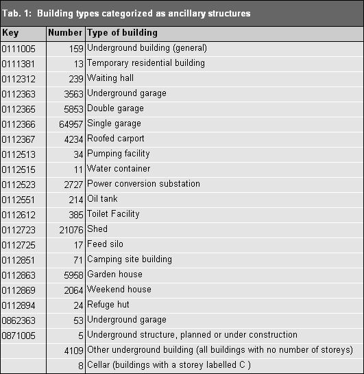
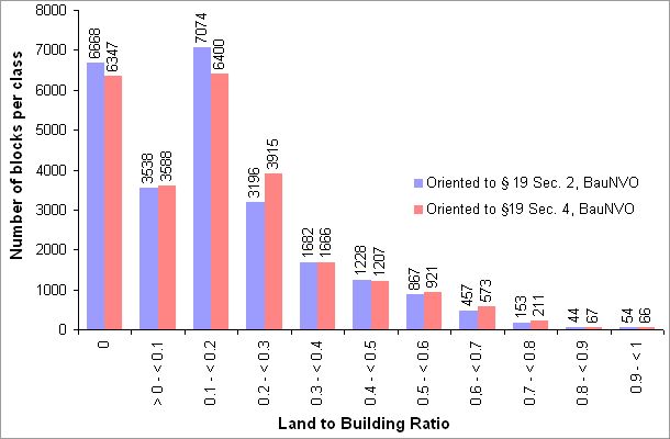
Consideration of Structural Facilities as per § 19, Sec. 4 BauNVO in the Ascertainment of LBR
According to § 19, Sec. 4 BauNVO, garages and carports, including their driveways and ancillary and structural facilities, have to be counted in the ascertainment of the base area.
As a first step, the so-called “main facilities” as per § 19, Sec. 2 BauNVO, were ascertained. In the second step, the base areas of garages, carports, underground car parks and ancillary structures listed in the ALK were added. The buildings of the types shown in Table 1 were categorized as ancillary structures if they had less than two storeys. These facilites do not affect the ascertainment of the FSI.
In cases in which aboveground and underground structures overlap, the aboveground structures were cut out of the underground structures (e.g. in the case of an underground parking ride in a building).
For the values of the land to building ratio (LBR) represented in the map, only the main systems as per § 19, Sec. 2 BauNVO were ascertained, hence without the ancillary structures, parking spaces etc. The values with ancillary structures, parking spaces etc. (§ 19, Sec. 4 BauNVO) are not shown on the map; however, they too were ascertained, and can be seen in the factual data display.