Actual Use of Built-up Areas / Inventory of Green and Open Spaces 2020

Methodology

Information about actual land use is managed and processed at the ISU (Informationssystem Stadt und Umwelt: Urban and Environmental Information System) based on a uniform spatial reference system.

The spatial reference system is provided by the Block Map 1 : 5,000 of the Urban and Environmental Information System (ISU5), which is in turn based on the Block Map of the Statistical Office of Berlin-Brandenburg (AfS). Each statistical block is as a rule delimited by streets. The numbering and the limitation of blocks is handled by the AfS in the Spatial Reference System (RBS, only in German) of the State of Berlin (Amt für Statistik Berlin-Brandenburg 2021b).

In the ISU block map, the RBS blocks can be further subdivided. The block segments constitute the smallest reference area here, and are delimited within a statistical block according to differing land use. The minimum size of the block segments is 1 ha. This means that any area interspersed with land uses below this size will be subordinate to the predominant use of the area. The block segments are not part of the statistical block system of the RBS, but are shown only in the block map of the ISU. Thus, a total of 26,378 blocks and block segments are currently recorded (as of December 31, 2020).

13,259 of these areas correspond to the statistical units of the Office of Statistics, while 3,315, mainly large and vacant blocks from the RBS, have been subdivided into 13,119 ISU block segment areas.

Deviations between RBS blocks and ISU block areas occur particularly where areas transition to road land. All areas, irrespective of their actual use, which are subject to the legal definition of “classification according to the road law” are considered ‘block-external’ in the RBS system. In individual cases, this may also include areas outside the road system, such as green spaces, car parks and even buildings, provided they are located on dedicated road land. Similarly, traffic islands or median strips, for example, are generally not recorded, even if they cover a larger area. For several years now, traffic islands and median strips have not been recorded, which is a departure from the original system, where traffic medians were managed as their own blocks.

The uniform reference system of the ISU facilitates an unambiguous spatial identification of all factual data relating to blocks and block segment areas. By means of a common key, which contains, among other things, borough, block and block segment area numbers, this data is assigned to the spatial reference system. It can then be linked to other factual data, such as the Population data (SenStadtWohn 2020b), in the ISU.

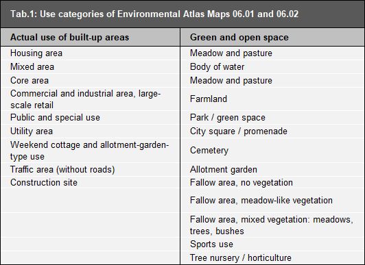
The Environmental Atlas Map “Actual Use of Built-Up Areas” (06.01) and “Inventory of Green and Open Spaces” (06.02), record the actual land use in Berlin on the basis of 22 different categories, which are described in greater detail in the following sections. The procedure for forming the block segment level in the ISU5 map and for the determining the various land use categories is detailed in the report which documents the mapping units and the updating of the 2020 database (SenStadtUm 2021a, only in German).

Tab. 1: Use categories of Environmental Atlas Maps 06.01 and 06.02

Tab. 1: Use categories of Environmental Atlas Maps 06.01 and 06.02

The maps “Actual Use of Built-Up Areas” (06.01) and “Inventory of Green and Open Spaces” (06.02) together constitute a comprehensive representation of actual land use.

For Public and special use, Utility area, Commercial and industrial use, Mixed use with commercial character and Traffic area, it is possible to simultaneously map certain green and open space use categories, in order to also permit ascertainment of any unusual vegetation-determined character of certain areas. Thus, in addition to their actual use, these areas are also characterised in terms of the type of their vegetation cover. As a result, for some areas with these uses, there is an overlap, or dual use, of the two maps . A sports field, for example, is marked as a Public use site in Map 06.01 and as Sports use in Map 06.02. A median strip may be recorded both as a Traffic area (Map 06.01) and a Fallow area (Map 06.02). For other uses, no dual use is allowed, since building use by definition, due to its high use intensity, either excludes parallel green use (e.g., core area use), or else may intrinsically already include a large share of green or open space (e.g., Weekend cottage and allotment garden-type area).

Dual use applies, for example:
  • in the ascertainment of ecologically relevant urban stocks of ruderal vegetation or forest-like stocks on low intensity traffic areas, or commercial or utility sites,
  • in the ascertainment of public and special use, which also exhibits the character of green use, such as borough horticultural offices, the field experimental fields of universities, or sports fields; or
  • in the ascertainment of linear stands of vegetation along railway lines and roads.

The mapping rules for dual use are presented in detail in the report which documents the mapping units and the updating of the 2020 database (SenStadtWohn 2021a, only in German).

Since many applications may or should only handle one piece of information on usage per area, it is important to also present the information of the two use mappings in aggregate form. For most applications in the environmental area, green and open space usage is of particular interest, as it shapes the ecological nature of an area (e.g., with regard to vegetation structure and evaporation behaviour). Other applications geared towards urban planning, however, are more interested in building use (e.g., when comparing the actual-use profiles with the use proposed in the land use plan, or assessing the impact of noise on those affected). Therefore, from 2010, the use has additionally been represented in the two maps “Actual Use” (06.01.1) and “Actual Use and Vegetation Cover” (06.02.1), in which both the uses of Map 06.01 and those of Map 06.02 are presented together. In Map 06.01.1, in case of dual use (currently 1,926 cases), the construction use is displayed, i.e. the presentation exhibits construction priority. By contrast, in Map 06.02.1 the presentation exhibits green priority, i.e., in case of dual use, green and open space use is shown. Each area may only be included once for the balancing of the shares of the individual categories in the urban area. This process ensures that the area share may be calculated separately, depending on the assessment goals.

Updating the Geometry and Usage Data

Update of the block (segment) area map of Berlin, 1 : 5,000 (ISU5)

The block boundary changes carried out between 2015 and 2020, including the current area key of the Berlin-Brandenburg Office of Statistics, have been adopted into the geometry of the ISU5. For all newly created blocks a use mapping procedure was carried out with the aid of aerial photography and other documents (see Statistical Base). Following the representation and differentiation system of the use and area classification of the Environmental Atlas, a further subdivision of the block areas into block segment areas was implemented where necessary, in order to distinguish different use- or area types from each other.

Plausibility check and comparison with various spatial data bases

In addition to the geometric update of the ISU5 block (segment area) map of Berlin, the update as of December 31, 2020 focussed on verifying the land uses and area types of the entire database using geodata that had been recorded in recent years by the Senate Departments and other bodies for a variety of specialised tasks (see Statistical Base). The rules on the permissibility of combinations of different land uses and area types were slightly revised as part of this. Furthermore, plausibility checks were carried out for the entire database following these rules (SenStadtWohn 2021a).

The various specialised databases were either already available as ISU block (segment) area data or could be merged and compared with the ISU block (segment) area map, which then revealed individual cases for which the use data had to be verified. For example, the existing data on the Site Occupancy Index (SOI) was used to check the allocation of the blocks of the area types commercial and industrial area with dense or sparse development. The SOI indicates the share of the area covered with structural facilities, compared to the size of the lot (cf. Article 19 Para. 1 of the Federal Land Utilisation Ordinance (BauNVO)). It was therefore examined whether commercial and industrial areas have an SOI greater or less than 0.5 (corresponding to building structures covering either more or less than 50 % of the area) in accordance with their definition (sparse / dense development).

Retrospective densification and any resulting changes in area type classification of residential, mixed and commercial uses were examined for the first time as part of the ISU5 block (segment) map update as of December 31, 2020. Furthermore, the data of the Housing Construction Space Information System (WoFIS) served as a new, valuable data basis, which provides information on planned and already implemented urban housing projects involving 50 residential units or more, identifiable by lot.

Scope of the update

The updated ISU5 block (segment) map consists of a total of 26,378 areas incl. bodies of water: 13,259 of which are main blocks and 13,119 block segments. A total of 18,862 areas with built-up use and 9,442 with green and open space use including 729 bodies of water were mapped. Thus, 1,926 areas showed dual use.

Extensive checks were carried out. In this context, areas were also identified, which were covered in more than one of these checks, as well as areas adjacent to areas under review, which were therefore also checked. Thus, the complete update results in a total of 5,846 areas, which were checked for their geometry or use. 596 block (segment) areas were assigned a new key and 506 block (segment) areas were dissolved. The use properties of 2,350 block (segment) areas and the geometry of 2,882 areas were changed. This revision covered about 16,036 ha or 20.2 % of the total block area (without roadway areas).

Independent of the use check, 301 main blocks were newly defined because of the updated statistical blocks of the RBS. As a result of the use check of these blocks, 72 block segments were subsequently newly defined.

The boundaries of 2,125 block segment areas and those of 993 block areas were geometrically adjusted in order to delineate uses with greater precision. Furthermore, 1,103 new block segment areas were formed in order to reflect the differentiation of the actual uses better.

For the first time, the check, changes and reasons for changes were documented in the geodatabase for each area that was checked.

Detailed documentation, which, in addition to the report on the current update of the actual use and urban structure mapping, also contains a presentation of the underlying concepts, mapping instructions, and a comprehensive description of all mapping units, may be downloaded at the following link: