The following is a common description for all single evaluations of the model calculations. Links to the individual main emphasis areas are provided for faster orientation in the text:
- Near-ground temperatures (10 PM) in the entire area;
- Near-ground temperatures (6 AM) in the entire area;
- Near-ground temperatures (10 PM and 6 AM) in the detailed-analysis area;
- Air exchange and air-mass currents (10 PM and 6 AM) in the entire area;
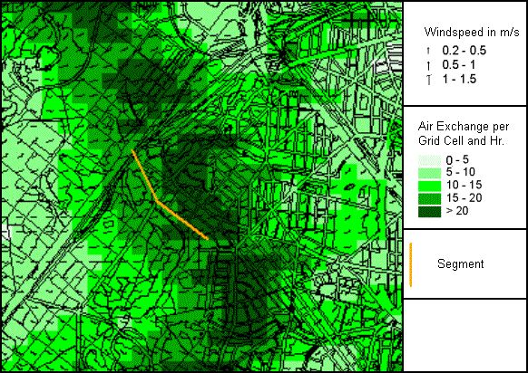
- Air exchange and air-mass currents (10 PM and 6 AM) in the detailed-analysis area.
The model calculations were started every day at sundown, and continued until sunrise the following day. The time segments 10 PM and 6 AM were evaluated and represented in the form of maps for the individual climate parameters. The 10 PM point in time represents the reversal from an irradiation to an exradiation situation shortly after sundown, and stands for the beginning of a phase with great cooling dynamics in the variously structured spaces in the urban area. The 6 AM point in time stands for maximum cooling within the urban structure.
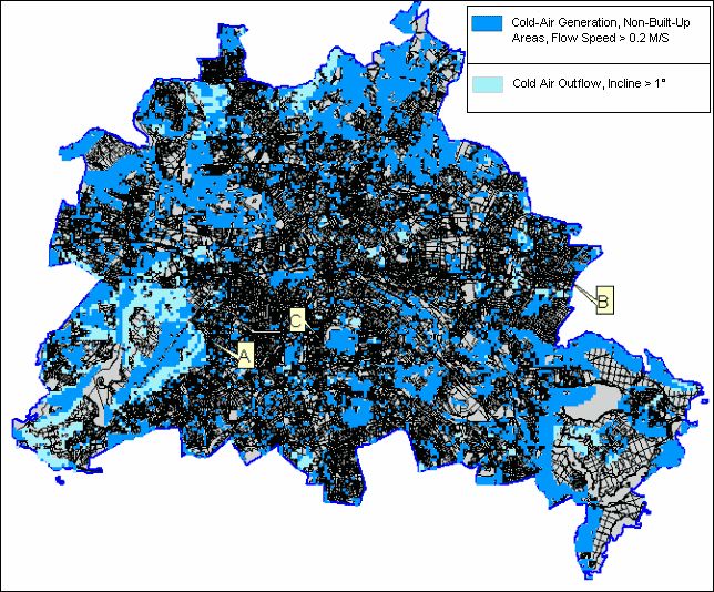
In the following single, exemplary results of the model calculations for the entire urban area or for the detailed-analysis area from the southern outskirts to the center will be briefly described. Fig. 3 provides a summary of the respective climatological parameters evaluated.
Near-Ground Temperature, General Remarks
The representation of the near-ground temperature field involves the grid instrument of temperature at the near-ground layer of the atmosphere (0-5 m above ground). If several land uses with different area shares are present within a grid cell, the temperature shown is calculated from the proportional weighting. Thus, the simulated temperature values are comparable only for larger areas with a uniform or comparable land use with ground-bound measurements.
Decisive for the temperature distribution are the land-use dependent soil and surface characteristics, as well as their interactions with the atmospheric processes in the near-ground boundary layer. Within the soil, heat and temperature conductivity are of importance in this regard. The greater the heat conductivity of the soil, for example, the faster and more deeply heat can penetrate into the corresponding material – but also: the faster it can escape again.
The surface composition of natural and artificial areas determines, via the albedo (reflection capacity) and the emissivity, the quantity of energy available in the short and long-wave ranges of radiation for warming/cooling. Finally, the turbulence condition of the near-ground atmosphere plays a major role in the transportation of perceptible and latent energy to and from the ground.
All processes mentioned are interconnected via the energy balance of the soil, and determine the temperature of the surfaces and the layers of air above them.
Near-Ground Temperature, Berlin and the Surrounding Countryside
The temperature conditions of the near-ground atmosphere 10 PM in the entire area are shown in Map 04.10.01. Due to the great variety of differences determined by land use of these effect quanta, a strongly structured spatial distribution of near-ground temperatures is simulated. Within the early nighttime hours (10 PM) the main land uses stand out against each other in a characteristic manner.
At this time, the wooded areas are approx. 1 K cooler than the surrounding open fields, and considerably colder than the built-up areas.
The open areas are heated up strongly during the day, and cool down after sundown just as strongly. Due to the relatively high evening base temperature, this cooling has on the whole not yet progressed sufficiently at the chosen point in time to reach the level of the cooler wooded areas.
Urban areas stand out considerably from their surroundings by an overall higher temperature level. However, the temperature distribution is spatially differentiated strongly in built-up areas, since, e.g., grid cells with detached house buildings, core areas, industrial areas and transportation facilities show strongly differing ground and surface characteristics. Moreover, the higher mean temperature level is interrupted by inner-city parks like the Great Tiergarten and the Tempelhof and Tegel airports.
Depending on the individual surface characteristics of the various land uses, the ground will cool down differently strongly during the night; Map 04.10.02 shows the temperature distribution at 6 AM.
While this cooling is very low for bodies of water, due to their good heat-accumulating qualities, open areas like fields and meadows show a strong drop in temperature. In wooded areas, the crowns of the trees protects the near-ground atmosphere below from cooling off strongly; therefore, forests stand out in the temperature distribution as relatively warm areas.
In the urban areas, cooling is reduced considerably by the presence of heat-storing materials like concrete and stone. For one thing, the quantity of heat stored during the day causes the temperature not to decline so strongly. Moreover, the low wind speeds of turbulent and latent heat currents, which might otherwise remove warm air, are reduced. The urban areas thus remain warmer overall. While the temperature difference vis-à-vis the undeveloped surrounding countryside is typically 2 K during the evening hours, this value increases to K 6 by the early morning hours. These great horizontal differences are not quite achieved in the inner-city open areas. Here, the proximity to the relatively warm built-up areas manifests itself.
Near-Ground Temperature – Detailed-Analysis Area, Southern Outskirts to Center
With an increase in the spatial resolution, the individual use types stand out against each other still more considerably in terms of temperature, especially in built-up areas (cf. Maps 04.10.07 and 04.10.08).
Grid cells which are completely filled with built-up areas are immediately adjacent to open areas, and thus exhibit temperature differences over very short distances. These differences are reduced only insignificantly, due to the fact that wind speed is strongly reduced in the urban areas, so that they are maintained during the nighttime hours.
The different building structures in the area selected are interrupted particularly by Tempelhof Airport, the Britz Garden recreational park and the open areas to the east and west of Lichtenrade.
The thermal behavior of the individual land uses is no different from the conditions described above for the entire area of Berlin. In the evening hours, the wooded sections of the parks are the coolest areas, followed by the open areas. Bodies of water show only a very low diurnal variation, and at this point in time fit into the temperature level of the general range of temperatures for the various built-up areas.
The land-use typical temperature conditions emerge clearly by the early morning hours. While the temperature above meadows and fields declines relatively strongly in the open fields surrounding Lichtenrade, the inner-city open areas, for example in the area of Tempelhof Airport, do not cool down to the same degree. This shows that the airport area is embedded in overall warmer surroundings.
Air Exchange and Air Mass Current as Criteria for Climate Compensation Measures
Good ventilation of residential areas can lead to a reduction in human bio-meteorological burdens (cf. Moriske and Turowski 2002). During the nighttime hours, the introduction of cooler air from the surrounding countryside can reduce the temperature level of the warmer air masses stored in the city, thus leading to a reduction of anthropogenic thermal pollution during the summer months. If this introduced cooler air (fresh air) is not burdened by air pollutants, the ventilation will also lead to an improvement in the air-quality situation.
Consequently, evaluation of the ventilation situation requires an appropriate assignment of burdened areas and compensation areas, which can make the appropriate unburdened air available, as well as a circulation system to ensure the transportation of the air mass.
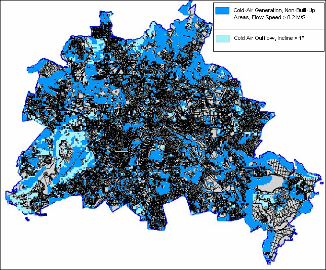
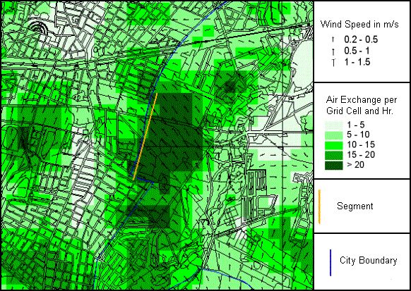
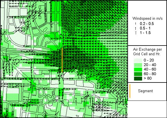
Climate-ecological compensation effects originate in undeveloped areas scattered throughout the urban area. They are characterized by a high vegetal proportion as well as a low degree of sealing of less than 20%, and improve the local climatic situation even in the densely built-up cores areas of Berlin (cf. Maps 04.10.03 through 04.10.06 for the entire city, or Maps 04.10.09 through 04.10.12 for the detailed-analysis area).
The compensatory effect is produced via thermally and/or orographically induced current systems. The following delimitation criteria were used to identify the open areas which provide neighboring built-up areas with fresh and/or cold air, and to be able to assign them to the various exchange processes. The self-generated compensation currents should achieve at least a speed of 0.2 m/s in climate-ecologically relevant open areas during a low-exchange, cloudless summer night. The compensation currents can be described as slope or valley winds if slopes or valley-floor inclinations of > 1° occur. Thermally induced current systems can be found in the relatively flat areas (cf. Fig. 6).

