New

The Environmental Atlas maps are available in the new Map Application

Solar Energy Systems

Map Description

The maps show both solar thermal and photovoltaic (PV) systems. Solar thermal data is limited to installations that have been registered for subsidies.

Off-grid PV systems – such as solar-powered parking meters, park lighting, and other units that do not feed electricity into the grid – are recorded separately and are not included here.

Map 08.09.1 Photovoltaics (PV)

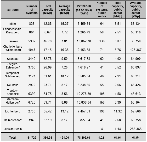
By 31 December 2024, Berlin had 41,723 registered PV systems. Most are small-scale, under 30 kWp (40,234 systems), while only 329 exceed 100 kWp. Together, they provide around 380.64 MWp of installed capacity, with larger installations contributing roughly 22 % (84.75 MWp) of the city’s total. Across the boroughs, Marzahn-Hellersdorf, Treptow-Köpenick, and Pankow are far ahead both in number of systems and total capacity. Lichtenberg is notable in terms of installed capacity: although it hosts fewer installations overall, a small number of high-capacity systems brings its total to 35.4 MWp. At the more detailed postcode level, suburban neighbourhoods dominated by single-family homes show the highest number of systems and the greatest number of postcode areas exceeding 1,000 kWp.

By 31 March 2024, 1,021 of the above-mentioned PV systems had been installed on public buildings across the city, with a combined capacity of 61.94 MWp. Lichtenberg has the highest system count (190), followed by Marzahn-Hellersdorf (158) and Pankow (138). Lichtenberg also ranks highest in installed capacity (11.32 MWp), with Charlottenburg-Wilmersdorf (8.76 MWp) and Marzahn-Hellersdorf (8.39 MWp) close behind. The public sector also operates several buildings outside the city that together host four PV systems with a total capacity of 1.14 MWp.

Tab. 1: PV system counts and installed capacity in Berlin’s boroughs (data as of 6 March 2025 for PV system deployment; 31 March 2024 for systems on public buildings, by borough; 17 January 2024 for PV feed-in)

Data source: Energieatlas Berlin, based on MaStR data of the BNetzA.

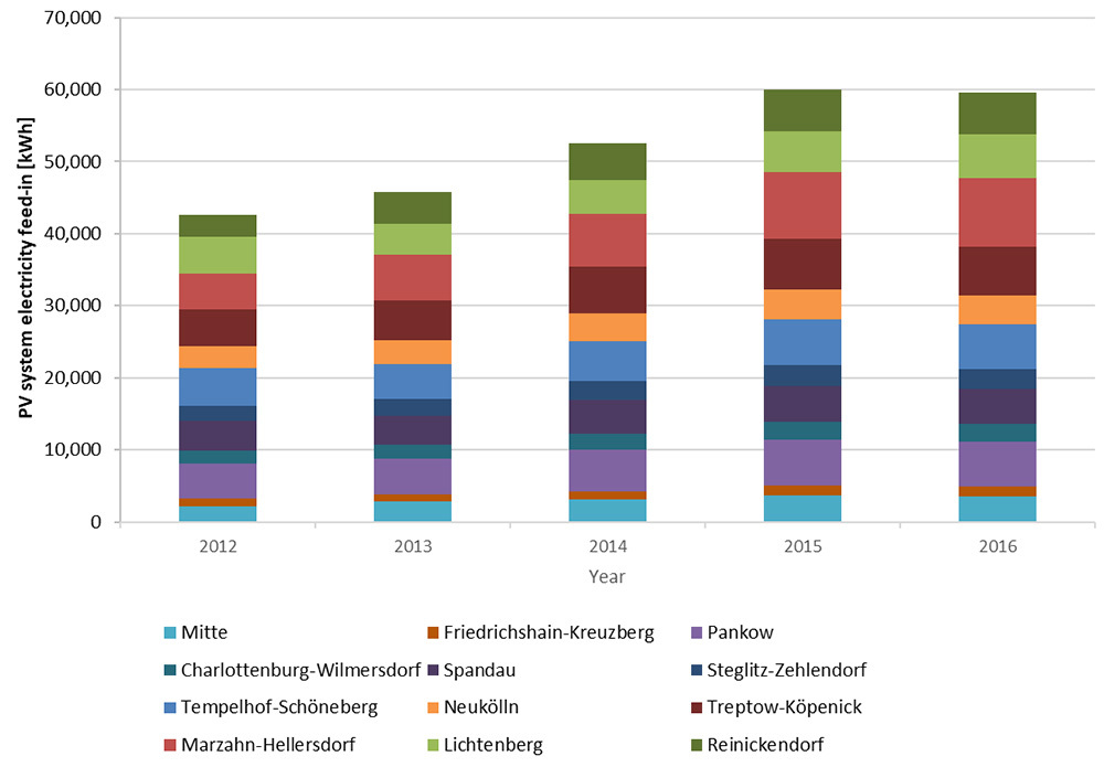
As many PV systems generate more electricity than is used for self-consumption, the surplus is fed into the public grid. Between 2012 and 2023, this total volume of surplus electricity rose steadily from around 43 GWh to 78.4 GWh (see Fig. 5). According to the latest data, the highest absolute numbers are recorded in the boroughs of Marzahn-Hellersdorf (13,836.8 MWh) and Treptow-Köpenick (10,278.8 MWh) (see Tab. 3). Overall, electricity fed into the grid is concentrated in the northern and eastern boroughs. By contrast, Friedrichshain-Kreuzberg records the lowest volume, reflecting its position as the borough with the fewest systems and a comparatively low total capacity. At the more detailed postcode level, residential areas dominated by single-family homes again stand out, mirroring the pattern observed for installed capacity.

Fig. 5: Electricity feed-ins of PV systems at the level of Berlin’s boroughs (as of December 31, 2018)

Tab. 2: Installed vs potential PV capacity, by borough. Data source: Solarcity Monitoringbericht, based on MaStR data of the BNetzA, as of 6 March 2024.

The most recent data on PV systems in Berlin, including system locations and borough-level deployment statistics, are available in map and chart form via the Energieatlas Berlin. A detailed annual analysis of PV expansion in the city is published separately in the Masterplan Solarcity Monitoringbericht (available in German only).

Results of the Rooftop PV Potential Assessment

Of approximately 536,000 buildings analysed, around 421,000 were identified as suitable for photovoltaic installations. If the 45.7 km² of theoretically suitable roof areas were fully fitted with PV modules (assuming a module efficiency of 19.5 %), they could generate roughly 7,929 GWh of electricity per year, avoiding an estimated 4.3 million tonnes of CO₂ emissions.

Tab. 3: Results of Berlin’s rooftop PV potential assessment (flat roofs assumed with elevated, south-facing systems; IP SYSCON 2022).

Tab. 3: Results of Berlin’s rooftop PV potential assessment (flat roofs assumed with elevated, south-facing systems; IP SYSCON 2022).

Map 08.09.2 Solar Thermal Energy (ST)

As there is no central register for solar thermal systems, a comprehensive dataset for Berlin is not currently available. Various approaches are being developed to strengthen the data foundation as part of the Masterplan Solarcity monitoring programme. Based on these methods, it is estimated that around 8,900 solar thermal systems were installed in Berlin in 2024, with a total collector area of approximately 94,300 m².

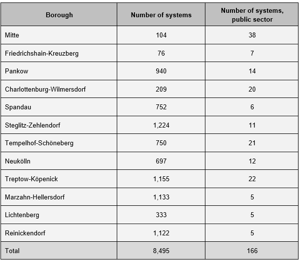
The majority of systems are located on the city’s outskirts. This pattern is evident in both detailed and aggregated map representations, which show system distribution by postcode and borough (data as of 31 March 2024). At the borough level, the highest concentrations are found in Steglitz-Zehlendorf (1,224 systems), Treptow-Köpenick (1,155), Marzahn-Hellersdorf (1,133) and Reinickendorf (1,122) (see Tab. 4). As with PV installations, most of these are smaller systems installed on privately owned single- and two-family homes (data as of 31 March 2024). By contrast, substantially fewer systems are recorded in the inner city, such as in the boroughs of Friedrichshain-Kreuzberg (76 systems), Mitte (104) and Charlottenburg-Wilmersdorf (209). These inner-city systems, however, often have higher rated capacity and/or greater heat generation potential, with collector areas typically ranging from 15 to 37 m², and are generally located on public-sector or commercial/industrial buildings (data as of 31 March 2024).

Tab. 4: Solar thermal system counts in Berlin’s boroughs (data as of 31 March 2024) and in the public sector (data as of 20 February 2024) for the year 2023.

Tab. 4: Solar thermal system counts in Berlin’s boroughs (data as of 31 March 2024) and in the public sector (data as of 20 February 2024) for the year 2023.

The most recent data on solar thermal systems in Berlin, including system locations and borough-level deployment statistics, are available in map and chart form via the Energieatlas Berlin (available in German only). A detailed annual analysis of solar thermal expansion in the city is published separately in the Masterplan Solarcity Monitoringbericht (available in German only).

Results of the Solar Thermal Potential Assessment

Of approximately 536,000 buildings analysed, more than 464,000 were identified as suitable for solar thermal installations, corresponding to a total potential collector area of 66.2 km².

Tab. 5: Results of Berlin’s rooftop solar thermal potential assessment (flat roofs assumed with elevated, south-facing systems; IP SYSCON 2022).

Tab. 5: Results of Berlin’s rooftop solar thermal potential assessment (flat roofs assumed with elevated, south-facing systems; IP SYSCON 2022).

Map 08.09.3 Solar Potential – Solar Irradiation

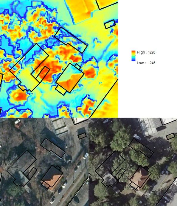
The calculated annual totals of global solar irradiation across Berlin’s urban surfaces span a broad range, from roughly 246 to about 1,220 kWh/(m²/a). For context, Germany’s National Meteorological Service (DWD) reports a mean annual total of 1,032 kWh/(m²/a) for the city. Extremely low rooftop values occur only where trees or surrounding structures cast significant shade (see Fig. 6).

Fig. 6: Effect of tree shading and roof orientation on calculated rooftop solar irradiation (mean annual totals in kWh/(m²/a)). Top: calculated solar irradiation for surface grids at 0.5 × 0.5 m² spatial resolution, with building footprints outlined in black. Bottom left: cropped section from an aerial image (February 2021); bottom right: cropped section from an aerial image (August 2020).

Fig. 6: Effect of tree shading and roof orientation on calculated rooftop solar irradiation (mean annual totals in kWh/(m²/a)). Top: calculated solar irradiation for surface grids at 0.5 × 0.5 m² spatial resolution, with building footprints outlined in black. Bottom left: cropped section from an aerial image (February 2021); bottom right: cropped section from an aerial image (August 2020).

The highest levels of solar irradiation are found on south-facing pitched roofs fully exposed to the sun, as well as on open vegetated areas such as the Tempelhofer Feld, where values can reach about 1,000 kWh/(m²/a). By contrast, forested and tree-covered areas receive much less sunlight, typically between 250 and 300 kWh/(m²/a), due to shading and surface characteristics.

These patterns closely reflect urban climate effects, as illustrated in the Urban Climate Atlas.

The Solar Potential – Solar Irradiation Map (08.09.3) can therefore be used for a wide range of applications.

Environmental Atlas Contact

Berlin Senate Department for Urban Development, Building and Housing
Mr. Hartbecke