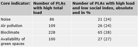
The correlation of this multiple load of the environmental variables with the social index indicates the connection, that is, the degree of environmental(in)justice, in Berlin.
Thus, the planning areas with two-, three- or even fourfold environmental load show a significantly higher share of low and very low index values. By contrast, PLAs without environmental load are predominantly characterised by very high/high index values.
Focus area inner city
The analysis of the spatial distribution of environmental justice shows a significant concentration in the inner-city area of Berlin, for example a high multiple load from environmental factors, which coincide with a low social status in the northern part of the borough Friedrichshain-Kreuzberg, in Wedding, the southern part of the borough Reinickendorf, and in northern Neukölln. By contrast, a very low/low environmental load and a very high/high social status can predominantly be found in the suburbs.
Upon a closer look at the numbers, especially in the focus area inner city, the following situation presents itself:
- In the extended inner city area, there are around 1.58 million inhabitants in total. Of the population affected by the individual core indicators, around 200,000 (12.7%) are affected by a high noise load, around 730,000 (46.2%) by high air pollution, 870,000 (55.1%) by low availability of green spaces and around 1.45 million (91.8%) inhabitants by a high bioclimatic load.
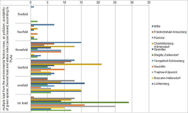
- The focus area is also disproportionally represented with respect to the number of planning areas with multiple load. 1 PLA with a fivefold load (out of 3 in total) is located here, 11 out of 17 with a fourfold load and 59 out of 71 with a 3-fold load.
- As for the affectedness of the inhabitants, the disproportionate load is also reflected in the individual indicators. Out of the 173 PLAs in the “priority area for air purity”, 29 (6.5% of all Berlin PLAs) are affected by a high/very high noise load, 85 (19.0%) by air pollution, 81 (18.1%) by low availability of green spaces, 152 (43.0%) by thermal load and 42 (9.4%) by a difficult social structure. Out of the 173 PLAs within the inner-city area, 64 (37.0% of the inner-city PLAs) have a predominantly (meaning more than 66% of the postal addresses) simple residential character, out of which 10 (5.8%) are additionally affected by a very high noise load and/or air pollution.
Borough-level evaluation
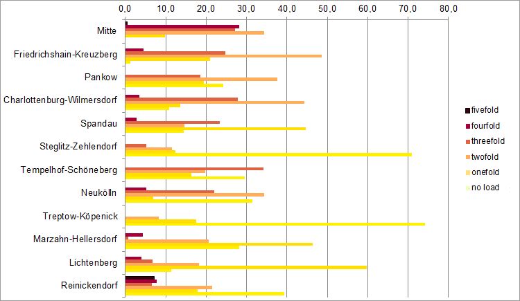
According to the above, a consideration at the borough level shows – not surprisingly – a severe inequality regarding the distribution of the multiple load.
With respect to the proportions of affectedness of the inhabitants, the Mitte borough has the highest load. At least 50% of the inhabitants are affected by at least a threefold load. Tempelhof-Schöneberg, Neukölln and Charlottenburg-Wilmersdorf are further boroughs with a relatively high share of affected population. By contrast, Treptow-Köpenick and Steglitz-Zehlendorf are the boroughs with the lowest percentage of inhabitants affected by multiple loads.
It also becomes evident that the affectedness varies significantly within the boroughs. The inner-city, densely developed districts (e.g. northern Neukölln) are almost always disadvantaged with respect to the more open areas.
In the Berlin suburbs where some Wilhelminian dense structures or large estates (whether east or west) are present (e.g. Spandau and Marzahn), higher categories of load are also regularly found.
Borough-level comparison of results
Across boroughs: