Legal Provisions and Competent Authorities
The “Directive of the European Parliament and of the Council relating to the assessment and management of environmental noise” (Directive 2002/49/EC) came into force on July18, 2002, when it was published in the Official Journal of the European Communities (now Official Journal of the European Union). For the European Communities, this opened the path to legal provisions covering noise immission into the environment.
The European Commission describes one of the rationales behind the Directive as follows:
“It is part of Community policy to achieve a high level of health and environmental protection, and one of the objectives to be pursued is protection against noise.”
It is therefore necessary, “to avoid, prevent or reduce on a prioritised basis the harmful effects, including annoyance, due to exposure to environmental noise. To that end, the following measures shall be implemented progressively:
- the determination of exposure to environmental noise, through noise mapping, by methods of assessment common to the Member States;
- ensuring that information on environmental noise and its effects is made available to the public;
- adoption of action plans by the Member States, based upon noise-mapping results, with a view to preventing and reducing environmental noise where necessary and particularly where exposure levels can induce harmful effects on human health and to preserving environmental noise quality where it is good.”
Furthermore, the Directive is intended to provide a basis for further developing and supplementing noise emission measures concerning the most important noise sources and to inform the European Commission about the exposure to environmental noise in the Member States.
The Senate Department for the Environment, Urban Mobility, Consumer Protection and Climate Action (SenUMVK) has commissioned and carried out the Noise Mapping 2022 (Level 4 updating the mapping of 2017) for the Berlin conurbation in accordance with the requirements of the Ordinance on Noise Mapping (Articles 4 and 5 of the amended 34th BImSchV in combination with Article 47 c BImSchG and Directive 2002/49/EC (EU Environmental Noise Directive)) and taking into account the current noise mapping instructions of the LAI (Federal Committee for Ambient Air Quality Protection).
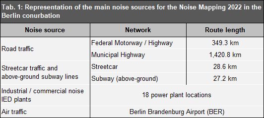
A number of different authorities are responsible for developing noise maps. Only those developed by the Senate Department for the Environment, Mobility, Consumer Protection and Climate Action are published here, addressing the areas of road traffic (motor vehicles incl. trucks and buses), tram traffic and underground traffic (of the above-ground sections), air traffic (BER) and IED plants (power plants).
The analysis of rail traffic noise according to the General Railway Act (AEG) is published here on the pages of the Federal Railway Authority (EBA, only in German).
The objective of the project is to develop strategic noise maps and prepare relevant statistical evaluations (exposed people, dwellings, schools and hospitals in specific immission level classes). The results were processed for further use with the following aspects in mind:
- basis for reporting to the EU and information of the public;
- basis for the continuation of the Noise Action Plan 2019-2023 (Berlin noise reduction planning (only in German));
- basis for the management of the source data (data model maintenance);
- basis for recalculations and the evaluation of demarcated areas.
Sections 47 a to f of the Federal Immission Control Act (BImSchG) regulate the implementation of the EU Environmental Noise Directive into German law. The Ordinance on Noise Mapping, 34th BImSchV, defines the requirements for noise maps in detail according to Article 47 c of the BImSchG.
Noise maps must always be based on calculations. These calculations are carried out according to EU-wide uniform calculation methods (CNOSSOS-EU) as well as the national calculation regulations applicable in this context (BUB-D).
Noise maps are to be reviewed and, if necessary, updated every five years from the time of their creation (Level 1 in 2007; Level 2 in 2012; Level 3 in 2017; Level 4 in 2022 etc.). The State of Berlin has met this obligation for all of the above-mentioned levels to date.