Climate Model Berlin - Analysis Maps 2001

Methodology

One important factor in the creation and formation of an urban climate are the soil and surface characteristics, which have been changed in the urban area in relation to the surrounding countryside. The result is urban overheating and also the local urban wind circulation. Wind and temperature as well as quanta derived from them are the dominant factors affecting the assessment of urban climate from the aspects of human bio-meteorology and air quality.

The investigation and recording of the urban climate can be carried out with the help of various methods. These include field measurements, long-range ascertainment methods, wind tunnel studies, and the application of numerical simulation models. Hitherto, the procedures of field measurement and long-range ascertainment have been used as a matter of priority for the recording of urban climatic phenomena for the Environmental Atlas of the Senate Department of Urban Development.

Direct numerical simulation models are particularly well capable of representing the meteorological quanta, which are spatially and temporally very strongly variable, due to the great complexity of the building structure.

The detailed calculation of the wind and temperature conditions in the Berlin area has been carried out using the FITNAH (Flow over Irregular Terrain with Natural and Anthropogenic Heat Sources) model. Groß 1993 and Richter & Röckle o.J. present detailed mathematical and physical descriptions of the model. Further detailed indications for the basic structure and approach of the three-dimensional FITNAH model, and for the interpretation of the model results, can be seen herein, on the basis of an exemplary comparison with measurement data, under Methodology/Supplementary Notes.

Generally, numerical simulation models are accepted for use in many fields of meteorology, since the data obtained provide important basic information for many areas of life (cf. Overview of the Most Important Models). The weather forecast for the next 1-5 days is obtained almost exclusively by means of such complex and extensive computer models. Knowledge of possible changes of our global climate over the next decades can also be derived from such calculations. And finally, models of a similar type are used to calculate the local and the regional distributions of meteorological variables in the atmosphere (Groß 2002).

The above-mentioned computer models for the various scales and task definitions, and also the FITNAH model used here, are all based on the same mathematical-physical system of equations. Only in detail are there scale-specific differences.

Meteorological Framework Conditions for the Model Calculation

In addition to the internal model definitions, the meteorological ancillary conditions play a major role. During high-pressure weather situations, the local climatically relevant particularities of a landscape are particularly noticeable. Such a weather situation is indicated by a cloudless sky and an only very light superimposed synoptic wind. The extensive synoptic framework conditions were fixed correspondingly for the numerical simulations carried out here.

Notes on Interpretation of the Model Results

In the horizontal dimension, FITNAH is based on a uniform grid, and in the vertical dimension on a stretched grid. By means of a proportionate assignment of the initial parameters, such as land use, terrain altitude, etc. to this grid, only a representative value can be calculated for every grid volume, which represents a weighted mean average value of all data obtained (cf. Methodology / Supplementary Notes).

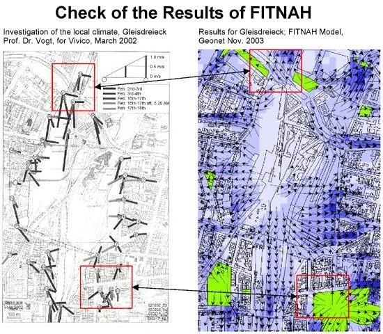
Verification of the Results of the FITNAH Climate Model

The information derived from the model runs was checked by means of data from a study of local climatic functions of open spaces in the Gleisdreieck area of Schöneberg. On the basis of an extensive comparison, the measurement results of the study were compared with the simulation results of the model application.

As a result of this comparison, a good level of agreement can be established between the results of the measurement project and the modeling of the local air-current field in the Gleisdreieck area using FITNAH.

The self-generated, local current phenomena postulated by the model calculations can largely be confirmed by the measurements. Details on flow direction and speed are within the same range. The relevant air exchange processes – small-scale, orographically caused cold-air outflow from the Viktoriapark area of Kreuzberg and thermally induced compensation currents between the open areas of the Gleisdreieck and the adjacent buildings – are recorded and represented equally, both qualitatively and quantitatively (cf. Vogt 2002a, pp. 26 et seqq.). However, a more regionally characterized compensation current between central Berlin and the surrounding countryside cannot be confirmed by either of the two methodological approaches (cf. Methodology / Supplementary Notes).

Methodology / Supplementary Notes

In the following, extensive additional information on the topical complex of the methodological processing of the Berlin climate model is provided. The text thus complements the contents of the chapter Methodology.

The Concept and Methodology of the FITNAH Climate Model

The basic structure of the three-dimensional FITNAH model consists of the conservation equations for impulse, mass and internal energy, as well as balance equations for moist components and additive elements to the air. The various turbulent currents are connected to the calculable mean quanta with the aid of empirical inclusions. The turbulent diffusion coefficient appearing in that context is calculated from the turbulent kinetic energy, for which an additional equation is solved.

The warming and cooling rates in the atmosphere due to the divergence of the long-wave radiant fluxes are calculated by means of a procedure in which the emissivity of the water vapor in the air is taken into account.

For detailed simulations in real terrain, the orography, and particularly the effect of wooded areas and urban structures on the distribution of the meteorological quanta must also be taken into account in a realistic manner. For this purpose, FITNAH is provided with special parameterization.

A forest or grove will be incorporated into the model via stock-specific quanta, such as tree height, stock density and tree species. This permits, among other things, the simulation of the reduction of the mean speed in the stock, the rise of the turbulence in the crown area and the strong nightly cooling in the upper crown third, in agreement with available observations. With consideration for the city-specific quanta building height, sealing and degree of construction coverage, and anthropogenic waste heat, the typical formation of an urban heat island at a reduced mean air current can be simulated (cf. Groß 1989).

The entire system of equations, including the parameterization, is transformed into a coordinate system which corresponds to the terrain. That permits, in particular, the formulation of the ancillary conditions of the various meteorological quanta in a problem-specific manner, specifically at the lower edge, the ground. The calculation of the earth surface temperature is carried out via an energy-flux balance, in which perceptible and latent heat current, the soil heat flow, short and long-wave radiation components, and anthropogenic heat flow are considered.

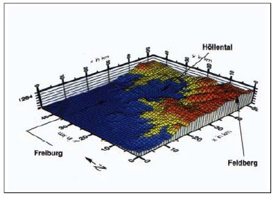
The differential equation of the equation system used is transferred to finite-difference equations and solved on a numerical grid. The spatial grid size Δx used here is 50 m and 200 m, respectively, in the two horizontal dimensions. The vertical grid interval is not equidistant, and the calculation areas are particularly dense in the near-ground atmosphere, in order to incorporate the strong variation of meteorological quanta realistically. The lowest calculation areas are located at heights of 5, 10, 15, 20, 30, 40, 50 and 70 m. the interval Δz becomes ever greater as the height increases, and the top limit of the model is located at a height of 3000 m above ground. This is the altitude at which it is assumed that the disturbances caused by orography and land use at ground level (cf. Fig. 4) will have faded away.

Beispiel für die Wiedergabe einer Naturlandschaft im Modellgebietscharakter

Fig. 4: Example for the representation of a natural landscape, in model-terrain character

Synoptic Framework Conditions for the Model Calculation

During high-pressure weather situations (autochthonous weather conditions), the local climatic particularities of a landscape can have a particularly strong effect. Such a weather situation is indicated by cloudless sky and an only very light overlaying synoptic wind. In the numerical simulations carried out here, the extensive synoptic framework conditions were established accordingly:

  • coverage degree: 0/8
  • geostrophic wind speed: 2 m/s (0 m/s)
  • relative humidity of air mass: 50%.

Notes on Interpretation of the Model Results

Due to the horizontal grid size used, 50 m and 200 m respectively, such items as single houses and buildings cannot be explicitly resolved. Rather, the model calculates a value representation of this grid volume (Δx·Δy·Δz) which represents a weighted mean average value of the land uses present.
This can be elucidated using the example of wind speed U: If 40% of the grid volume is filled with buildings (UHaus = 0 m/s) and 60% without flow obstacles (e.g. UFrei = 1 m/s), then the representative wind speed, which is also calculated by the model, will be:

40 % · UHaus + 60 % · UFrei = 0.6 m/s

Landuse Area share Temperature
Water Area share 20 % TWater = 18 °C
Open area Area share 40 % TFrei = 14 °C
City Area share 30 % TCityt = 17 °C
Woods Area share 10 % TWoods = 16 °C

then a representative value of TModell = 15,9 °C is calculated for the grid.

Verification of the Results of the Climate Model FITNAH

To check the informational levels derived from the model runs, a study of local climatic functions in the open spaces of the Gleisdreieck area can be used. The orienting investigation on current and temperature fields in the Gleisdreieck area is methodologically composed of:

  • stationary measurement, summer semester 2001 (four measurement operations); and
  • mobile measurements, winter semester 2001-2002 (four measurement operations).

The meteorological framework conditions seemed suitable to permit self-generated current systems to develop in the area of the Gleisdreieck (cf. Vogt 2002a and Vogt 2002b).

The following working hypotheses were to be checked by the measurement operations:

  1. There is an autochthonous, regional current which transports cold air over the low-friction structures of the track area (i.e., an air-stream channel) from the Teltow area into the center of Berlin;
  2. The Gleisdreieck area, which is characterized by open spaces, provides cold air to the immediately adjacent built-up neighborhoods;
  3. There is a cold-air outflow from the area of Viktoria Park in Kreuzberg, which intrudes into the open spaces of the Gleisdreieck area.

These assumptions agree with the hypotheses on the formation of autochthonous current systems between differently structured urban areas in this investigation, and therefore should be ascertainable again in the model results of the FITNAH simulations as well. The measurement data on the current field can therefore be used to check the plausibility of the model results herein.

However, a restricted applicability of this comparison must be assumed:

  • The meteorological framework conditions for measurement were not in every case ideal for the clear development of self-generated current systems.
  • A mobile and stationary measurement can always have only a random-sample character (spatially and temporally).
  • The mobile measurements carried out during the winter semester were conducted during periods of extreme sub-freezing temperatures.
  • “Virtually stationary” short-term measurements are involved, since at each of the 37 measurement points in sequence, the wind field parameters were ascertained for approx. 4 minutes. The measurement procedures for the recording of the wind field for this area probably lasted about 4 to 5 hours. Thus, what is represented is not a wind field for a defined period of time.
  • In the model runs which were used for the comparison, ideal framework conditions for the formation of self-generated current systems were assumed, i.e. the top current has a speed of 0 m/s.

Check of the Working Hypotheses on the Autochthonous Current Field

In this comparison, the results achieved within the early nighttime hours at 2.5 m above ground are to be considered as a matter of priority. Thus, far-reaching comparability of the model vs. the measurement results is ensured in this regard. The comparison is carried out on the basis of an established working hypothesis on flow conditions in the area under investigation:

  • There is an autochthonous, regional current which transports cold air over the low-friction structures of the track area (i.e., an air-stream channel) from the Teltow area into the center of Berlin.

Neither in the measurement procedure nor in the model calculations can any regional current be ascertained which uses the low-friction open spaces of the railway facilities as an air-stream channel.

Any such current system would have had to be demonstrated in the measurements at the Monumentenbrücke measurement point (cf. Vogt 2002a, p. 14). However, all that could be ascertained from the measurement operations was the intervention of the top current into the relatively low-friction, vegetal areas of the Gleisdreieck. Even the mobile, winter measurement ascertained no such current (cf. Vogt 2002b, pp. 78 et seqq.).

The model result, too, would not support any extensive exchange current. The current field (10 PM) shows a locally determined mosaic of small-scale air exchange cells, which are for the most part thermally induced. As a rule, the spatial extent of these “current cells” is between 800 m and 2000 m (cf. Fig. 5).

  • The Gleisdreieck area, which is characterized by open spaces, provides cold air to the immediately adjacent built-up neighborhoods.

The measurement provided clear indications of the existence of these local equalization currents (cf. Vogt 2002a, p. 15). However, the less-than-optimal meteorological framework conditions during many of the measurement procedures and the temporal delay at mobile measurements prevented a comprehensive illustration of these current systems.

On the other hand, the model results generated by FITNAH provide a comprehensive picture of the spatial character of these local, primarily thermally induced current systems. In addition to the item-related statements of the measurements, the model results permit statements concerning the range (i.e., penetration depth) of the flows into the adjacent built-up areas. The area between the Lützowstrasse and Kurfürstenstrasse test points on the western edge of the Gleisdreieck area can be taken as an example. The cold air formed locally here penetrates approx. 440 m into the built-up area.

The flow speeds measured or modeled achieve very similar orders of magnitude. As a rule, these thermally induced current systems are accompanied by wind speeds of from 0.1 to 0.5 m/s. The measurement projects indicate that these value were achieved both in the summer and the winter semesters (cf. Vogt 2002a, pp. 19 and 22).

  • There is a cold-air outflow from the area of Victoria Park in Kreuzberg, which intrudes into the open spaces of the Gleisdreieck area.

The measurement results on local cold-air outflow from the area of Viktoria Park in Kreuzberg confirm these FITNAH simulation calculations (cf. Vogt 2002a, p. 17). The measurements confirmed the canalization of the cold-air outflow through the Katzbachstrasse-Möckernstrasse corridor. This current was accompanied by low wind speeds of 0.7 to 0.2 m/s.

The advance of orographically-determined cold-air outflows up to the area of Gleisdreieck is also confirmed by the model results. In the area of Yorkstrasse/ Katzbachstrasse, an advance of cold air into the open spaces of the Gleisdreieck can be ascertained. The penetration depth of cold air from the area of Victoria Park is about 300 m (cf. Fig. 5).

Fig. 5: Verification of the results of the climate model FITNAH (Fig. right) on the basis of stationary and mobile measurements in the area of Gleisdreieck in the left Figure, the lines emanating from the measurement points point in the direction from which the wind comes; in the right Figure, the wind arrows point in the flow direction.

Fig. 5: Verification of the results of the climate model FITNAH (Fig. right) on the basis of stationary and mobile measurements in the area of Gleisdreieck in the left Figure, the lines emanating from the measurement points point in the direction from which the wind comes; in the right Figure, the wind arrows point in the flow direction.

Result

Overall, there is good agreement between the results of the measurement procedure and the modeling of the local current field in the Gleisdreieck area using FITNAH.

The self-generated, local current phenomena postulated by the model calculations can largely be confirmed by the measurements. Data on flow direction and speed are within the same ranges. The relevant air exchange processes – small-scale, orographically-determined cold-air outflows from the Viktoriapark in Kreuzberg and thermally induced compensation currents between the open spaces of the Gleisdreieck and the adjacent built-up neighborhoods – have been ascertained and represented equally, both qualitatively and quantitatively (cf. Vogt 2002a, pp. 26 et seqq.). However, it was not possible, by either of the two methodical approaches, to support any regionally-characterized compensation current between central Berlin and the surrounding countryside.