The first complete Map of Soil Associations for West Berlin was prepared by Grenzius in 1984, and the map was published in the Environmental Atlas (SenStadtUm 1985).
Soils in a landscape segment interact with neighbouring soils, air, water, and vegetation. Grenzius did not identify individual soil types, but rather combined soil types that interact with each other in a given landscape segment (geomorphic units) into soil associations. These soil associations were studied and evaluated for their location characteristics.
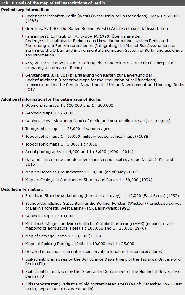
The present Map of Soil Associations was prepared for West Berlin based on the Map of Soil Associations and commentaries by Grenzius (Grenzius 1987), which define and describe soil associations. It was updated in 1990 for the first time. The assignment of soil associations, the definition of new soil associations and concept soil associations for East Berlin were enabled by a transposition concept (Aey 1991) based on conclusions by analogy, and with the aid of information from geologic and topographic maps, forest site surveys, detailed maps, aerial photography analyses, and information on land use and degrees of impervious coverage. Newer soil maps and an updated map of land use in West Berlin necessitated a reworking and updating of the Map of Soil Associations for West Berlin. For the first time, a soil map was created in the mid-1990s for the entire city (SenStadtUmTech 1998). It was updated in 2003. Changes in land use, updated data on impervious soil coverage and depth to groundwater, however, required further updates in 2008, 2012 and 2017. The results are thus presented here. Tab. 3 shows the data bases and preliminary information used throughout the developing process of the map.