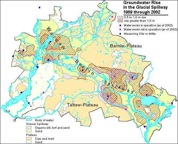
The present map describes the groundwater situation of the main aquifer by means of groundwater isolines. These show the piezometric surface area of the unconfined and confined groundwater (see also Fig. 2).
The map basis is the General Map of Berlin, 1: 50,000, in grid format with an underlayed geological outline. In addition, the individual waterworks are indicated, with their wells and water conservation areas.
Hydrogeologic Situation
On the plateaus, the main aquifer is extensively covered by the glacial till and bolder clay (aquitards) of the ground moraines. Wherever the piezometric surface of the main aquifer lies within this aquitard, groundwater conditions are confined. This may at times result in the formation of perched groundwater in sandy areas above the glacial till (see also Fig. 2).
On the Barnim Plateau to the north, an independent coherent aquifer has developed in the Panke Valley. It is located over the main aquifer, which is covered by the glacial till of the ground moraine (aquitard). In the present map, this aquifer is indicated by an overlay (red cross-hatching). For the sake of clarity, no overlay of the isolines of this upper aquifer is shown. The incline of this groundwater also runs from northeast to southwest. A spur of the glacial till toward the Warsaw-Berlin Glacial Spillway creates an interlock of the Panke Valley aquifer with the main aquifer there.
Hydraulic Situation
As a rule, the groundwater incline in Berlin is oriented from the Barnim and Teltow Plateaus and the Nauen Plate toward the receiving bodies, the Spree and Havel Rivers.
Depression cones have formed around the wells at the waterworks; during the measurement period, they have sunk the groundwater surface below the level of the neighboring surface waters: Thus, in addition to inflowing groundwater from the shore side, the water pumped here also includes groundwater formed by infiltration from these aboveground waters (bank-filtered water) (see also Fig. 3).
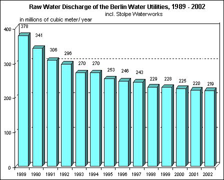
However, in May 2002, the phreatic surface, which has been strongly shaped in Berlin by drinking-water discharge over the past hundred years, was, all in all, at a relatively high level, as it had been during the previous seven years. The reason for this was declining water consumption, which can be seen from the reduced raw-water discharge by the Berlin Water Utility. Five small Berlin waterworks discontinued their production altogether during the period between 1991 and 1997: Altglienicke, Friedrichsfelde, Köpenick, Riemeisterfenn and Buch. In addition, drinking water production at the two waterworks Johannisthal and Jungfernheide was discontinued temporarily in September 2001; at the latter, the same was true for artificial groundwater recharging. In the context of groundwater management by the Senate Department for Urban Development, groundwater is, however still discharged at both locations, so as not to endanger current local waste disposal and construction measures.
The overall discharge of the waterworks for drinking water purposes has dropped by over 40% in Berlin during the past 14 years (Fig. 7). In 1989, 378 million m³ were discharged, as opposed to 219 million m³ in 2002.