Urban Structure 1990

Statistical Base

For the registration of the area types, a multitude of different statistical bases were used.

This is based on the area types created in 1988 for West Berlin for the working file of the Environmental Information System (Umweltinformationssystem – UIS) of the Berlin Department of Urban Development and Environmental Protection. Their differentiation is based on the categorization of the 1981 Map of Open-space Types for the Blocks, which was compiled as the basis for the Berlin Landscape Program. The categorization criteria for distinction of the various open-space types were construction and free-space structure, age of the buildings, and use.

The most important statistical source was infrared aerial photography from the aerial operation of August 1990, which exists in two different resolution standards: one for West Berlin and the area close to the former border, at a scale of 1:4,000 and for the area of East Berlin at a scale of 1:6,000.

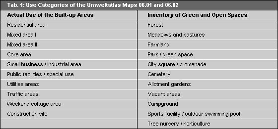
The Umweltatlas (Environmental Atlas) Maps 06.01 “Actual Use of Built-up Areas,” and 06.02 “Inventory of Green and Open Spaces,” were compiled simultaneously with the present map in the years 1990-‘91, and record the actual land use of Berlin on the basis of 21 different classes (cf. Tab. 1).

Tab. 1: Use Categories of the Umweltatlas Maps 06.01 and 06.02

Tab. 1: Use Categories of the Umweltatlas Maps 06.01 and 06.02

These classes are shown according to the predominant use at block or block-segment level.

Especially for West Berlin, the 1989 Maps of Uniform-use Block Segments were additionally used to update the area types. They are shown on the basis of the maps of Berlin at a scale of 1:4,000. With the aid of these maps, the public facilities areas could, for example, be designated separately.

For East Berlin further statistical bases were used: The Maps of Berlin at a scale of 1:5,000 from the years 1968 to 1989, which show the construction structure of Berlin.

For clarification of the transferability of the area types defined in West Berlin, the expert study Typical Development Structures of Residential Areas, by the Institute for Urban Development and Architecture of the Construction Academy (ISA), 1990, which evaluated the so-called representative file, a file of the Data Base of Area Elements containing information on the construction structures of neighborhoods as of 1989 were used.

The maps Age of Building Groups and Story-Structure of Residential Buildings, are evaluations of the data base “Housing Policy and Building Stock,” of the Institute for Urban Development and Architecture (ISA). They have been available for the individual boroughs at a scale of 1:10,000, in some cases also at 1:30,000, since 1991, and cover approx. 70% of the entire housing stock. The private housing stock is not covered. In the map “Age of Building Groups,” the proportions of housing built before 1919, between 1919 and 1948, between 1949 and 1970, and after 1970 are shown in relation to the housing units at the level of the 904 neighborhoods. In the map Story-Structure of Residential Buildings, apartment buildings are grouped into categories of one or two floors, three or four floors, five floors, six to eight floors, nine to eleven floors and more than eleven floors.

For the eastern boroughs within the City Rail Circle Line, the 1988 map Building Ages, at a scale of 1:10,000, shows the age of the buildings as broken down into eight categories.

The Topographical Street Map (military edition) of 1986 -1989 (scale 1:10,000), and the Land Use Maps of the boroughs (inventory), permit differentiation of common-use areas.