The map was updated on the statistical base of the edition 2005, edition 2002 and edition 1995 (see text there)
The update of the edition 2007 (data base 31.12.2005) was implemented by an external contractor. Changes of land use between 2001 and 2005 were mapped and adaptations of geometries of the Digital Map of Berlin 1:5,000 (ISU 5) were made. The following statistical bases were used:
- Digital Map of Berlin 1:5,000 of the Urban and Environmental Information System (ISU) of the Senate Department for Urban Development, IIIF; status: 2005-12. with new block segments and actual block numbers
- Geometrical changes of the blocks from the Spacial Framework (Räumliches Bezugssystem RBS) of the Department of Statistics (Amt für Statistik in Berlin-Brandenburg, formerly Statistisches Landesamt Berlin) 2002-2005
- Digital aerial photographies (orthophotographies), 2006, SenStadt Abt. III (archive for aerial views)
- Area inspection by Cornelia Nitzsche
- Update and mapping of all railroad areas, 2007, Geoinfo, Cornelia Nitzsche
With help of the data bases specified above, limitations, use and section type of altogether 806 sections and 696 railroad sections (compared to edition 2004), were defined.
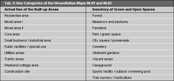
The Umweltatlas Maps (Environmental Atlas) 06.01 "Actual Use of Built-up Areas", and 06.02 "Inventory of Green and Open Spaces", were compiled simultaneously with the present map and record the actual land use of Berlin on the basis of 21 different classes (cf. Tab. 1).