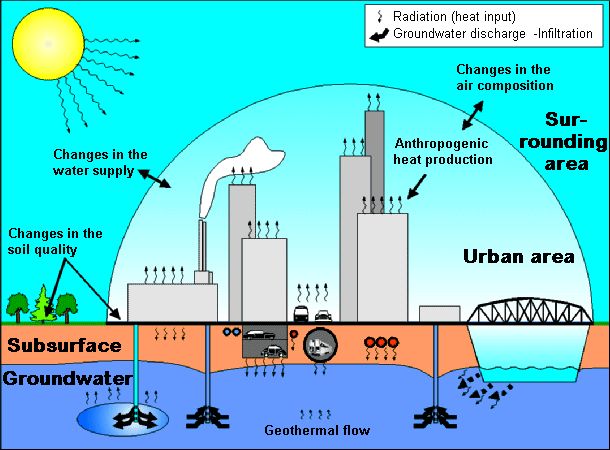
The causes for the rising temperature are varied and are directly connected with the increasing urbanization of the land. There are many influences from direct to indirect for the change in groundwater temperature (cf. Fig. 1):
-
Direct influences to the groundwater temperature are caused from all of the heat produced by: the sewage network, hot-water-heating-pipes, electric lines and subterranean constructions like: auto and subway tunnels, underground garages etc.
- Groundwater heat-use and storage e.g. in connection with the use of heat pumps.
-
Indirect influences to the groundwater temperature are caused by the course of urbanization, that originates with the change of heat regime in the lower atmosphere. By Gross (1991) important indicators are:
- The disturbance of the water regime because of a high degree of surface sealing
- The change of soil property caused by an accumulation of houses (differences in the near surface heat production and heat capacity)
- The changes of radiation caused by changes in the atmosphere
- The anthropogenic heat generation (domestic heating, industry and transportation)
In comparison to the surroundings a change of the heating regime has been caused by the above mentioned reasons. The city heats itself slowly, storing altogether more heat and gives this again slowly to the surroundings, that means it is being generally considered as a huge heat saver. In the long term this process increases the average of the air as well as soil temperature ( cf. maps of the topic 04 climate).
This long term warming of the soil leads also to a warming of the groundwater. The temperature influences the physical characteristics such as the chemical and biological composition of the groundwater. It can also result in the deterioration of the groundwater quality.
One hundred percent of Berlin’s drinking water comes from groundwater, which is being extracted almost exclusively from the city area. The groundwater also supplies a large percentage of the needed water for industrial uses. Therefore, the protection of the groundwater from hard changes like the raising of the groundwater temperature, is of high importance-specifically in the context of sustainable water use.
Since 1978 the deep groundwater measurements points from the entire city have been processed and evaluated to strengthen received temperature profiles that include both a chronological and spacial depiction of the groundwater fields.
The presented map should be:
- the beginning of a documentation of the temporal changes of the groundwater temperature under the City
- and serve as permission basis for actions that would cause changes in the groundwater temperature
Additionally it can be combined with other map topics (for example: geological, hydrological) for decision making and preplanning of an energetic management of the groundwater.
With help from heat pumps or probes the surplus heat can be used. Fossil fuels are being saved in this way, as a contribution to progressive energy politics by the reduction of harmful climate gas emissions.
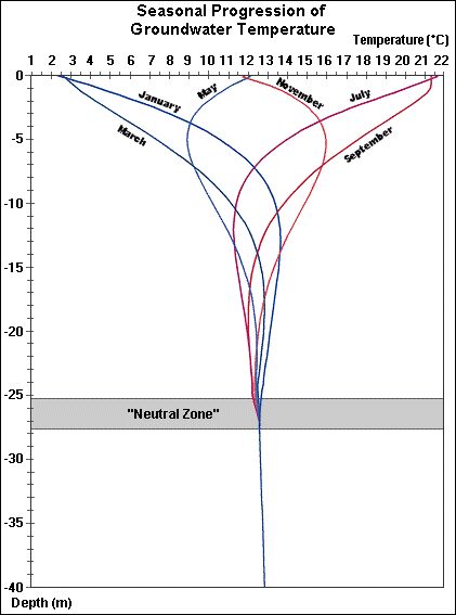
Groundwater Temperature and Annual Temperature Path
The substantial heat source for the earth is Solar radiation, which is responsible for the surface temperature. The radiated solar energy warms the near surface ground and this in turn warms the atmosphere and the underground. The regular energy from the sun on the surface of the earth amounts to an average of ca. 0,75 kW/m2. Different surface types and elevations, as well as both seasonal and daily changes to the amount of sun exposure, lead to local and time deviations from the median value.
The surface temperature penetrates with decreasing intensity into the ground. The penetrated depth and the speed in which the heat is transported depends on the heat transfer ability of the ground.
The heat transfer in the ground can be distinguished between conductive and convective heat transfer.
During the convective heat transfer the heat movement occurs through the material (for example ground and seepage water), on the other hand the conductive transfer results from the transportation of energy through push "processes" between molecules.
There is also another form of surface heating, that comes out of the earth and passes to the surface. It is called the earth heat flow. It originates in the production of heat from the decay of radioactive isotopes. However this form of heating is much weaker than the sun.
In the continental crust of the earth the heat flow density is defined as the heat flow per unit area perpendicular to the standard area, so there are regional differences (Hurtig & Oelsner, 1979). The heat flow density in the Berlin area amounts to ca. 80 mW/m2.
The near surface groundwater temperature is therefore essentially caused by the exchange of heat between the sun, the earth’s surface and the atmosphere, with a much smaller amount from the earth heat flow directed at the surface.
The regional average annual temperature at the surface in Berlin, under anthropogenically unbiased conditions, is ca 8,5 to 9°C.
Daily fluctuation affect the ground only up to a depth of about 1,5 m, while seasonal fluctuations affect a depth of ca. 20 – 30 m. Below this depth the seasonal influence is no longer registered, This is the beginning of the so called neutral zone. At this point temperatures rise depending on the heat transfer ability of the rocks and the regional heat flow density (Fig. 2).
In the Berlin area the average rise in temperature in this region, until a depth of ca. 300m, is 3°C per 100m.