Groundwater Levels of the Main Aquifer and Panke Valley Aquifer 2016

Methodology

The groundwater contours of the Main Aquifer as well as the Panke Valley Aquifer were calculated using an interpolation method (point-Kriging). In order to obtain information about the interrelation between the measuring points, concerning their spatial distribution and groundwater level, data were first analysed by variogram analysis.

The geo-statistical parameters ascertained by variogram analysis for the Main Groundwater Aquifer and the Panke Valley Aquifer are listed in Table 1.

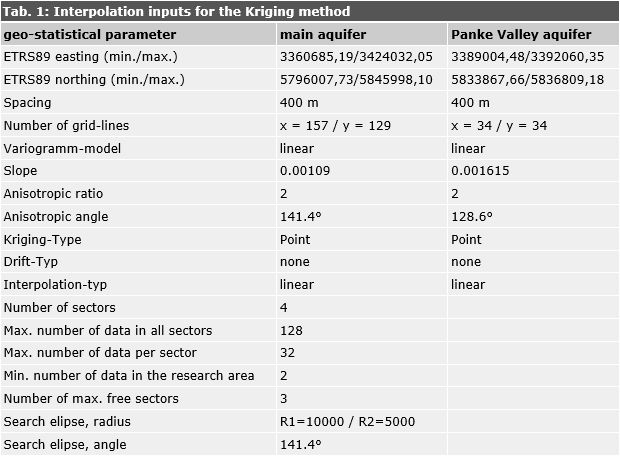
Tab. 1: Interpolation inputs for the Kriging method

Tab. 1: Interpolation inputs for the Kriging method

The irregularly distributed groundwater and surface measurement data were transformed into an equidistant grid with a spacing of 400 m, with the aid of a program for the calculation and graphic representation of surfaces (Surfer 10.0, by Golden Software). This was accomplished by interpolation according to the Kriging method. The groundwater contours were represented on the basis of this grid, after smoothing.

An groundwater contour map with a grid width of 200 m, updated monthly, has been prepared for internal official use ( Hannappel & et al. 2007 ).