Depth to the Water Table 2005

Introduction

Groundwater levels in a metropolitan area like Berlin are subject not only to such natural factors as precipitation, evaporation and subterranean outflows, but are also strongly influenced by such human factors as water withdrawal, construction, surface permeability, drainage facilities, and recharge.

The main factors of withdrawal include the groundwater demands of public water suppliers, private water discharge (cf. Map 02.11), and the lowering of groundwater levels at construction sites. Groundwater recharge is accomplished by precipitation (cf. Map 02.13.5), shore filtration, artificial recharge with surface water, and return of groundwater at construction sites.

In Berlin, there are two potentiometric surfaces (groundwater layers). The deeper level carries salt water and is separated from the upper potentiometric surface by an approx. 80 meter thick layer of clay, except at occasional fault points in the clay. The upper level carries fresh water and has an average thickness of 150 meters. It is the source of Berlin’s drinking (potable) and process (non-potable) water supplies. It consists of a variable combination of permeable and cohesive loose sediments. Sand and gravel (permeable layers) combine to form the groundwater aquifer, while the clay, silt and organic silt (cohesive layers) constitute the aquitard.

The potentiometric surface is dependent on the (usually slight) gradient of groundwater and the terrain morphology (cf. Fig. 1).

Fig. 1: Terminological definition of depth to the water table at unconfined and confined groundwater

Fig. 1: Terminological definition of depth to the water table at unconfined and confined groundwater

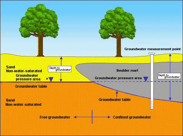
The depth to the water table is defined as the perpendicular distance between the upper edge of the surface and the upper edge of the groundwater surface. If the groundwater aquifer is covered by relatively impermeable, cohesive layers (such aquitards as boulder marl), so that it is unable to rise to the level that its hydrostatic pressure would dictate, it is considered to be confined groundwater. In such a case, the depth to the water table is defined as the perpendicular distance between the upper edge of the surface and the lower edge of the groundwater-obstructing boulder-marl layer which covers the aquifer (cf. Fig. 1).

The Map of Depth to the Water Table gives an overview of the spatial distribution of areas with the same depth classifications, at a scale of 1 : 50,000 (SenStadt 2006). It was calculated on the basis of the data of May 2006, and applies to the respective near-surface aquifer with an uninterrupted water supply. In Berlin, this in most cases means the main aquifer, which is used for water supply (Aquifer 2, according to the structure of Limberg und Thierbach 2002), and which is unconfined in the glacial spillway, but confined in the more elevated areas. In exceptional cases, the Aquifer 1 (e.g. in the area of the Panke Valley) or the Aquifer 4 (tertiary formations) were used to determine the depth to the water table.

Areas with a lesser depth to the groundwater table (to about 4 meters) are of particular importance. Soil pollution can quickly lead to deterioration of groundwater in these areas, depending on the nature of the mantle (permeable or non-permeable) above the groundwater. The Map of Depth to the Water Table is thus a significant basis for the preparation of the Map of the Protective Function of Groundwater Coverage (cf. Map 02.16). The spatial overlaying of depth to the water table onto geological characteristics of the covering mantle permits the delimitation of areas of varying protective functions of groundwater confinement).

Knowledge of depths to groundwater moreover permits an assessment of the effect of groundwater on vegetation. This depends on the root depths of plants and, depending on soil type, of the capillary climbing capacity of groundwater. The threshold depth at which groundwater can be used by trees under the conditions prevailing in Berlin is generally given as 4 meters. Vegetation in wetlands depends mostly on the groundwater, and requires a depth to the water table of less than 50 cm.

Fluctuation of Groundwater Levels

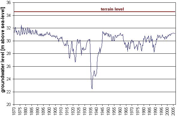
The groundwater level in the city is subject to various anthropogenic influences. The first lowering of the groundwater level and the destruction of wetlands in the Berlin area was caused by the drainage of such swampy areas as the Hopfenbruch in Wilmersdorf in the 18th century. The 19th and 20th centuries saw the drainage of other areas due to the construction of canals. The groundwater level was further lowered by the increasing demand for drinking and process water, and by restrictions on groundwater recharging caused by surface sealing, or was subjected to strong periodic fluctuations, with amplitudes of up to 10 meters at a site.

Up to the end of the 19th century, the mean groundwater level in Berlin was subject only to the annual fluctuation in precipitation. During the period between 1890 and the end of World War II, the rising water demands of the rapidly growing city, as well as unwatering operations, marked the water-supply picture. Large-scale unwatering of the subway and urban-rail networks (Alexanderplatz), and other major construction projects caused the groundwater level in the inner city to drop dramatically by up to 8 meters. With the breakdown of the public water supply at the end of the war, the depth to the water table was able to recover almost to its natural level (Fig. 2).

During the ensuing period, from the early ‘50s to the early ‘80s, the groundwater level sank continually and over large areas because of increased withdrawal. This was particularly noticeable in water discharge areas (waterworks facilities). The lowering was caused by the general rise in water consumption by private households, and by construction (rebuilding of the severely destroyed city, subway construction, and large-scale construction projects). The expansion of water discharge facilities in the West Berlin waterworks was completed by the beginning of the ‘70s. The expansion of the Friedrichshagen Waterworks in East Berlin began in the mid-‘70s, to supply water to the new residential areas in Hellersdorf, Marzahn and Hohenschönhausen.

Fig. 2: Fluctuation of groundwater levels at measuring site 5140 in Mitte (Charlottenstraße), since 1870

Fig. 2: Fluctuation of groundwater levels at measuring site 5140 in Mitte (Charlottenstraße), since 1870

Permanent, wide and deep cones of depression have formed in water catchment areas around the wells of the waterworks. Moreover, parallel to the variations in withdrawal requirements at the respective waterworks over the course of a year, often considerable fluctuations in groundwater levels are observable there. Riemeister Lake and Nikolas Lake were dried out by the water withdrawals of the Beelitzhof Waterworks at the beginning of the 20th century. The groundwater level of Schlachten Lake fell by 2 meters, and at Krumme Lanke by 1 meter. Since 1913, water from the Havel has been withdrawn into the Grunewald lakes (inversion of natural flow) to balance this loss. The wetlands Hundekehle Fen, Langes Luch and Riemeister Fen, as well as the shore areas of the lakes, have been saved by this measure.

The cones of depression around well galleries at the Havel Lake have effects deep into the Grunewald (forest). The groundwater level at Postfenn sank by 3.5 meters between 1954 and 1974, and at Pech Lake in the Grunewald by about 4.5 meters between 1955 and 1975. Well gallery withdrawals at the banks of the Havel have caused severe drying out of root soils of plants in the direct vicinity of the Havel.

About 90% of the wetlands around Müggel Lake in southeastern Berlin are threatened (Krumme Laake, Müggelheim, Teufelssee Bog, Neue Wiesen/Kuhgraben, Mostpfuhl, Thyrn, the lower course of Fredersdorf Stream).

Some wetland areas were flooded and fed with surface water to percolate, in order to moderate the negative effects of the lowering of groundwater levels. These included the West Berlin nature reserves Großer Rohrpfuhl and Teufelsbruch in the Spandau Forest, and Bars Lake in Grunewald, and also, in East Berlin, Krumme Laake in Grünau and Schildow in Pankow.

Large-scale lowering of groundwater levels has also occurred in the Spandau Forest, caused by the higher withdrawals by the Spandau Waterwork since the ‘70s. With the aid of a groundwater recharging plant, operated since 1983, attempts have been made to gradually raise groundwater levels again by allowing purified Havel water to seep in. The groundwater level in the Spandau Forest had been raised by an average of 0.5 – 2.5 meters by May 1987. Groundwater recharging in this area has been restricted again because water has appeared in cellars of near-by residential areas. The simultaneously increase in the withdrawal quantities of the Spandau Waterworks lowered the groundwater level again after 1990. During the ensuing period, the groundwater level rose once more, due to the further reduction in withdrawal quantities.

Fig. 3: Fluctuation of groundwater levels at measuring site 1516 in Spandau Forest

Fig. 3: Fluctuation of groundwater levels at measuring site 1516 in Spandau Forest

Generally, a rise in groundwater levels has been observable in West Berlin since the end of the ‘80s. Three measures against the trend of dropping groundwater levels were the primary reason for this:

  • The rise in artificial groundwater augmentation with cleaned surface water in areas near the waterworks (Spandau, Tegel and Jungfernheide) led to reductions in the amounts of lowering (cf. Map 02.11)
  • The enforcement of groundwater return in cases of groundwater reservoir measures connected with major construction projects reduced the burden on the basic water balance.
  • The introduction of the groundwater withdrawal fees led to thriftier management of groundwater resources.

In May 2006, the potentiometric surface was, all in all, at a relatively high level. The reason for this was declining water consumption, which can be seen from the reduced raw-water intake by the Berlin Water Utility since the political change in East Germany, especially in the eastern boroughs. Five small Berlin waterworks discontinued their production completely during the period between 1991 and 1997: Altglienicke, Friedrichsfelde, Köpenick, Riemeisterfenn and Buch. As a result, the groundwater levels rose again citywide through the mid-‘90s. During this period, numerous cases of water damage occurred locally due to sudden groundwater resurgence in cellars which were not properly sealed. The damage was so extensive in two areas (Rudow, Kaulsdorf) that groundwater-regulatory measures had to be carried out.

In addition, drinking-water production at the two waterworks Johannisthal and Jungfernheide was discontinued temporarily in September 2001; at the latter, the same was true for artificial groundwater amplification. In the context of groundwater management of the Senate Department for Urban Affairs, groundwater is however still withdrawn at Johannisthal, so as not to endanger current local waste disposal and construction measures. At the Jungfernheide site, groundwater maintenance has been carried out by Siemens AG since January 2006, in order to protect the buildings.

The overall intake of the waterworks for drinking water purposes has dropped by over 40% in Berlin over 17 years: In 1989, 378 million cu. m were withdrawn, as opposed to 218 million cu. m in 2006.

The drop in groundwater intake by the Utility in the eastern boroughs was even considerably higher – at 60% – during this period. The result was a city-wide groundwater level rise since 1989, which most strongly affected the areas near the wells of the waterworks in the glacial spillway, with their deep cones of depression.

Fig. 4 shows the extent of the large-scale rise in ground-water levels since 1989. The map shows the rise in ground-water levels between 1989 and 2002.

Fig. 4: Groundwater Rise during the Period 1989 through 2002.

Fig. 4: Groundwater Rise during the Period 1989 through 2002.

h6. The groundwater rise is shown only in the glacial spillway, since this where it is relevant for buildings, due to the low depth to the groundwater table. On the plateaus, depths to groundwater are greater.