Berlin is characterised by a grown multi central structure with two main centers beside the specific district centers: the areas “Zoologischer Garten” and “Mitte”. As a rule, population density increases from the city edge to the city center, however there are some focal points in the borough centers like Spandau, Tegel and Köpenick. Particulary the region of the central area Mitte, that means the area around the eastern Greater Tiergarten and in the north and south of the boulevard Unter den Linden is predominantly formed by its functions as the governmental area and as a supra regional and significant center for services and commerce. Only in some blocks more than 70 p/ha are found.
Leipziger Strasse (street) and the new residence units on Wilhelmstrasse are densely populated and are conspicuous exceptions to general conditions in the city center.
In contrast the second Berlin wide meaningful center around the Zoologischer Garten and along the boulevard Kurfürstendamm is more or less well preserved as a residential area, whereby this is a relevant contribution to the vitality of city life.
The Wilhelminische Ring stands out with a “predominately high population density of 351 and more p/ha”. The area has a block structure from the late 19th-century and is located within and on the edge of the City Rail Circle line. Maximum values with more than 700 p/ha occur only in about 20 of the overall 14,500 blocks and block segments in Berlin. These areas are located in the boroughs of Neukölln, Kreuzberg and Lichtenberg.
Outside the City Rail Circle line, the relatively high population density continues south into the Schöneberg, Friedenau, and Steglitz boroughs. Population distribution similar to that within the inner City Rail Circle line is found in older development areas of Spandau, and is similar to other areas such as Tegel, Schöneweide, Adlershof, and Tempelhof. When these areas were developed around the turn of the century, they were on the edge of Berlin. They were later incorporated into Berlin.
The high-rise and industrially-prefabricated settlements at the edge of the city are relatively densely populated with 151 to more than 350 p/ha in large block areas. These are Märkisches Viertel, Hohenschönhausen, Marzahn, Hellersdorf, and Gropiusstadt.
Small settlements with post-war high-rise development fall predominately in the 151 to 250 p/ha range. These areas at the edge of the city in Spandau, Lichterfelde, Marienfelde, Waidmannslust, Bohnsdorf, and Köpenick are relatively less densely populated. Some locations in this population density class are settlements with block-edge and row development. Examples are Haselhorst, Siemensstadt, Zehlendorf, and Plänterwald.
Typical for the city edge, and the most numerous, are relatively thinly populated settlements with 5 – 150 p/ha. These blocks are block-edge or row development, 71 – 150 p/ha; low developments with yards, 5 – 70 p/ha; and villa developments with park-like gardens and some semi-private re-greening, 31 – 70 p/ha.
An interesting development can be observed at the eastern city border in comparison to the map of the population density in 1994. Because of divisions of real estates and in the consequence constructional compressions the predominant number of blocks are nowadays in the density category of 31-70 p/ha, whereas for the data from 1994/31/12 blocks with less than 30 p/ha are in the majority. Therefore as a result of this development in the field of population density the eastern border of Berlin bears resemblance to the western border.
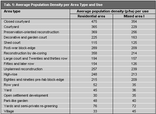
The distribution of population density correlates quite clearly with Environmental Atlas Map 06.07, “Urban Structure”. It is apparent that area types can be assigned a certain range of population density. Table 1 gives average population densities for residential area types (proportion of more than 75% of the use within the area) and respectively Mixed Areas I (more than 25% proportion of trade and services). These calculations are based only on areas (blocks or block segments) of uniform use.

