The term population density is a measure of how many people live in a given area. Population density as used here is the number of inhabitants per hectare (1 hectare is an area about 86 yards on a side. 1 hectare = 2.47 acres, or 1 acre = 0.4047 hectare. 640 acres = 1 sq. mile). The population density of Berlin’s entire urban area is 37 people/hectare (p/ha). This figure is in the middle range for German and European cities. Hamburg has an average of 38 % fewer people per hectare. Paris has a population density almost six times greater (cf. Fig. 1).
New
The Environmental Atlas maps are available in the new Map Application
Population Density 2005
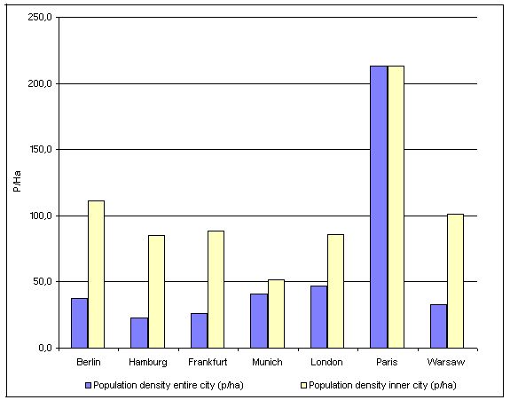
Fig. 1: Population Density of Berlin Compared to other Cities, in People per Hectare (Data from 2000-2005)
Image: Umweltatlas Berlin
In Paris the inner city and the municipal border of the city area are overlaying; the nearest major administration unit is the Ile-de-France with 12,000 km² and about 11,000,000 inhabitants (9.1 p/ha).
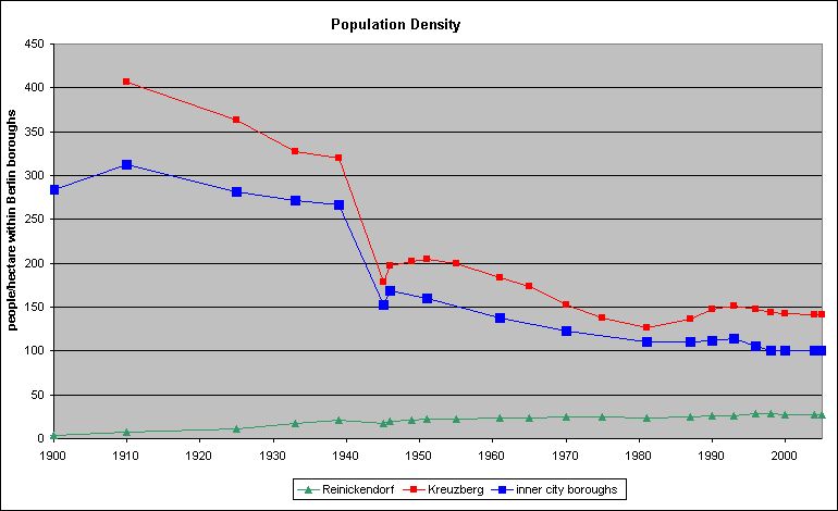
Fig. 2: Development of Population Density for Selected Berlin Boroughs (people/hectare within Berlin boroughs)
Image: Umweltatlas Berlin
Population figures for inner city boroughs existed only as a total sum for the years 1871 and 1900. No population data for the eastern city boroughs was available between 1949 and 1975. This prevented a calculation of population density for inner city boroughs for these years.
Environmental Atlas Contact
Berlin Senate Department for Urban Development, Building and Housing
Mr. Döllefeld