New

The Environmental Atlas maps are available in the new Map Application

Water Balance 2022

Overview

A comprehensive understanding of the water balance is essential for planning and managing water resources in line with the principles of sustainability. In Berlin, this is particularly important because the city has comparatively limited water resources. There is a clear mismatch between the available supply, the number of the city’s inhabitants and their needs for drinking and service water, and the resulting wastewater volumes. For this reason, accurately quantifying the components of the water balance is crucial.

In addition:

  • For surface water protection, it is important to estimate how much surface water is discharged into local water bodies, as rainwater can carry significant pollutant loads.
  • For groundwater protection, it is important to understand the infiltration capacity of soils, since contaminants from polluted soils are largely transported through infiltrating water.
  • For nature conservation and landscape management, it is important to assess the water available to vegetation from groundwater recharge and from capillary rise at the groundwater table.

The water an area receives through precipitation is distributed among the various components of the water balance in varying amounts, depending on climatic conditions and local characteristics. These components include evapotranspiration, surface runoff, sub-surface runoff (infiltration or groundwater recharge), and changes in water storage. The first parameter to be determined is total runoff, which represents the sum of surface and sub-surface runoff.

According to the general water balance equation, total runoff equals the difference between precipitation and actual evapotranspiration. In this calculation, evapotranspiration is the key factor and, under natural conditions, is largely controlled by vegetation, climate, and soil characteristics.

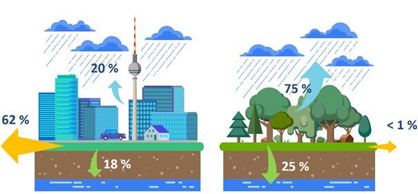
In urban areas, actual evapotranspiration is strongly influenced by local conditions and can differ markedly from that in the surrounding countryside. Buildings and paved surfaces greatly reduce the amount of water returned to the atmosphere compared with vegetated areas. While plants continuously release moisture through their foliage via transpiration, only a small fraction of rainwater remains on buildings and paved surfaces, where it can evaporate. As a result, total runoff is much higher in urban areas than in vegetated areas.

In Berlin, green roofs have increasingly been used in recent years as a measure of rainwater management. They help reduce runoff and provide additional surfaces for evapotranspiration. To account for this effect, Berlin’s green roofs (see Environmental Atlas Map 06.11) have been included in the Environmental Atlas water balance maps since 2017.

The maps presented here for 2022 form part of the results from the AMAREX research project (AMAREX is the acronym for the German translation of ‘adaptation of stormwater management to extreme events’). This joint project is funded by the Federal Ministry of Research, Technology and Space (BMFTR) within the hydrological extreme events (WaX) funding programme (funding reference: 02WEE1624A-H). The initiative operates under the umbrella of the federal water programme Wasser: N and is part of the BMFTR’s Research for Sustainability Strategy (FONA).

AMAREX - Förderkennzeichen

The Berlin Water-Balance Model ABIMO 3.2 (AbflussBIldungsMOdell) was released as open-source software prior to the start of the project (https://github.com/umweltatlas/abimo, available in German only). During the project, ABIMO 3.2 was extensively tested and further developed by the Berlin Centre of Competence for Water (KWB) (https://www.kompetenz-wasser.de/en). The following presents key developments and newly introduced parameters, which are discussed in more detail in the Methodology section:

  • Validation of the model’s calculations by comparing them with discharge data from Berlin’s wastewater treatment plants (see Excursus).
  • Conversion of the former C++ application into an R-based version.
  • Separate water balance modelling for block (segment) areas and road areas.
  • Correction of an error in the earlier infiltration calculation for block (segment) areas containing both road and non-road surfaces, which had led to an overestimation of the proportion of pervious surfaces.
  • Integration of the influence of green roofs into the water balance modelling of the R-based application.
  • Option to include the effects of infiltration basins (these were not shown in the citywide maps due to insufficient data; however, the AMAREX Webtool allows users to incorporate infiltration basins into their planning).
  • Use of the Green Volume Number (GVZ) from 2020 (see Environmental Atlas Map 05.09) to determine specific evaporation parameters for each block (segment) or road area, replacing the previous standard assignment by land-use category.
  • Development of the new parameter ΔW (Delta W), expressing the deviation of the water balance from natural conditions as a percentage.
  • Generalisation of the model logic to improve its transferability to other locations (Berlin-specific input variables, such as urban structure type and land-use category, were removed. Instead, parameters derived from these, such as yield and irrigation, were included directly as input variables. This allowed the model to be successfully transferred and applied to the city of Cologne.)
  • Development of the AMAREX Webtool (https://amarex-staging.netlify.app/amarex, available in German only): a planning tool that enables users to select any area within Berlin and apply various measures, such as removing impervious soil covers, adding green roofs, or connecting areas to infiltration basins. For the selected measures chosen for planning, the tool displays water-balance parameters both for the current situation and the scenario after implementation. Results can be saved, reloaded, and printed as a report.

The version of ABIMO that was further developed within the AMAREX project is published at https://github.com/KWB-R/kwb.rabimo.

For further findings from the AMAREX project beyond the scope of the water balance, see Environmental Atlas Map 02.25 (available in German only) or visit www.amarex-projekt.de/en.

Fig. 1: Typical water balance for impervious versus vegetated surfaces (blue arrows: evapotranspiration; yellow arrows: surface runoff; green arrows: infiltration)

Fig. 1: Typical water balance for impervious versus vegetated surfaces (blue arrows: evapotranspiration; yellow arrows: surface runoff; green arrows: infiltration)

Total runoff is the best parameter to capture hydrological conditions of individual sections and catchment areas. For a catchment with defined boundaries, the sum of the runoff generated by all sections corresponds to the total surface and sub-surface runoff of the area, representing the available water resources.

In urban areas with impervious surfaces, part of the total runoff reaches watercourses directly via discharge points, or indirectly through wastewater treatment plants, depending on whether these surfaces are connected to the sewer system. (Translator’s note: ‘sewer system’ refers throughout this document to combined or separate sewer systems, with the focus on rainwater rather than wastewater.) The remaining runoff infiltrates into the ground at the edges of impervious areas or within partially permeable areas, percolating into deeper soil layers below the zone influenced by evaporation and thereby recharging the groundwater. Where sewer system information is available, infiltration and groundwater recharge can be determined by subtracting the volume of water discharged into the system from the total runoff.

The resulting values for infiltration and surface runoff are primarily relevant for water management purposes and form important parameters for describing the urban water balance.

When assessing soil performance for precautionary soil protection or evaluating environmental impacts under the Federal Nature Conservation Act (BNatSchG), the infiltration rate of pervious or unpaved soils plays a key role. This parameter allows, on the one hand, the identification of differences in soil infiltration capacity, and on the other, an assessment during the planning process of how impervious surface materials might affect the infiltration capacity within a given planning area. Such assessments cannot be made using the values shown in Map 02.13.2 (Percolation from Precipitation), since the reference areas depicted represent averages for segments containing both impervious and pervious surfaces – including portions that are connected to the sewer system and those that are not.

For this reason, in addition to Map 02.13.2, infiltration on pervious surfaces has been separately determined and illustrated in Map 02.13.4. The maps show precipitation infiltration without taking impervious cover into account. Within the framework of the AMAREX research project, the assumptions underlying this representation were revised. As before, the proportion of impervious cover was set to 0 % for all areas. In addition, for areas that are impervious in reality, an urban park area with a mix of vegetated and tree-covered surfaces was assumed. For vegetated areas with higher vegetation intensity (previously indicated by the parameter ‘yield class’) than an urban park, such as forests, no changes were made. The infiltration of precipitation on pervious soils is represented in the Regulatory Function for the Water Balance Map (Environmental Atlas Map 01.12.4), which is part of the broader Soil Functions mapping.

According to the technical rule DWA M 102-4, deviations from the natural water balance should be kept to a minimum in new development projects. To quantify such deviations, the AMAREX research project developed the parameter ΔW (Map 02.13.6), based on the three water-balance components: surface runoff, evapotranspiration, and infiltration. This parameter expresses the percentage deviation from the water balance of a natural reference scenario, defined as an urban park area with a mix of vegetated and tree-covered surfaces. By definition, the reference scenario is pervious or unpaved and undeveloped.

Groundwater recharge refers to the process by which infiltrating precipitation contributes to groundwater formation. The volume of groundwater recharge differs from the total amount of percolating water, as it is reduced by the fraction of interflow, the portion of runoff that moves laterally through the upper soil layers into receiving waters.

Understanding the magnitude of groundwater recharge is particularly important given expected changes to the water balance resulting from climate change. It is a key factor for the long-term, sustainable use of groundwater resources and is also essential for assessing the potential risk of pollutant transport from the unsaturated zone into the groundwater (Verleger & Limberg 2013; Löschner 2008).

Contact

Leilah Haag