Basic Situation
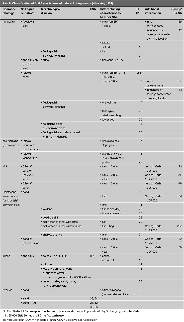
Aey (1991) wrote a guide for the preparation of a Concept Map of Soil Associations in the entire city. This guide was based on: 1) the method described by Grenzius (1987) for the preparation of a Soil Association Map for West Berlin; 2) the Map of Soil Associations by Grenzius which was transferred into the spacial reference system of Information System (ISU) by Fahrenhorst, Haubrok, and Sydow (1990). No Soil Association Map of this or a similar kind existed for East Berlin. The bases for the development of the soil association map of West Berlin were the excavations and drilling stock samples conducted in all of West Berlin. These were conducted in forest plantations and agricultural areas under consideration of geomorphological-hydrological conditions, and, in populated areas, under consideration of uses. All parent rock and most uses, with the exception of industrial areas, were surveyed several times, and mapping was begun. The evaluation of this mapping enabled analogical conclusions for soil conditions at unmapped areas.
The comprehensive soil science studes used for the Map of Soil Associations in West Berlin have verified the Map for many areas, such as forest and agricultural areas (farmland). The map is to be regarded as partially verified for areas with lesser degrees of soil science studies. Such detailed soil mapping for East Berlin only exists for forests. All derivations and determinations of soil associations for East Berlin – except for forest plantations – had to be made on the basis of analogical conclusions and existing material, such as geological and topographical maps, soil maps, and area uses, etc.. The accuracy, informational content, and age of this material varied greatly.
More precise classification schemes for soil associations, as well as the definition of new soil associations not yet described by Grenzius were enabled by maps and soil studies conducted in West Berlin after the publication of the West Berlin Soil Association Map, as well as existing soil maps for East Berlin, particularly for forest plantation areas.
The existing map for East Berlin is to be regarded as confirmed only for forest plantations. It is a concept map for all other areas. This is the reason why the entire map itself is to be regarded only as a concept map with some confirmed areas.
The map scale of 1 : 50,000 does not allow the spatial distribution of individual soil types to be portrayed. Unifying units had to be selected. Soils of spacial and material coherence were combined as soil associations.
Naming
The naming of the soil associations was based on the interactions of characteristic soils. The first and last soil of the association were given in the German system, and, usually, one of the soils that characterizes material translocations (Grenzius 1987). This interacting system, or the link between soils in areas still extensively near-natural is characterized in the map legend by “-”.
Near-natural soils are found only in loosely settled areas.
The structures of soils in settled areas have sometimes been greatly altered by human influences. Anthrosols appear randomly next to each other and are connected in the legend by “+”.
The legend is structured according to the degree of anthropogenic influence on and alterations of the soil. Near-natural soils are at the beginning; first the terrestrial soils, and then the semi-terrestrial soils. Soil associations of anthropogenic aggradations and erosion are listed at the end. (Translator’s note: “aggradation” describes soils and materials which have been placed somewhere by natural processes (glaciers, water flows) or human actions. Anthropogenic aggradations include deep landfills (waste and debris depots, etc.), and shallow landfill of upper layers (playgrounds, building construction sites, street construction, etc.))
Drawn Borders
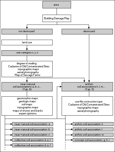
The borders were drawn between soil associations at ridges and sinks (relief). Neighboring units could then show the same beginning and ending points. The area delineation of soil associations also had to conform to the Berlin Digital Spatial Reference System based on block and block segment areas of homogeneous use. If this procedure would have led to great losses of information, particularly in non-built-up and loosely built-up areas such as forests, agricultural areas, and settled areas with low degrees of sealing, then these areas were further divided according to the borders of the soil associations. The decisive factors in these cases were the borders of geomorphological and geological units, contour lines, soil types (detail map), and aggradation borders. The factors for the delineation of anthric soil associations were area uses and the borders of aggradation (accumulation) or erosion.
Near-natural and Anthric Soil Associations
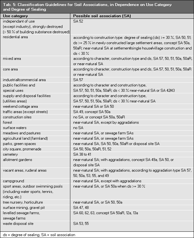
Determining factors for soil development are parent substrate, prevailing soil type, relief (slope, sink, channel, gradient etc.), water and climate conditions, as well as the degree of human influence. Anthropogenic influences are characterized by aggradation of natural soil material and non-natural soil materials (war debris, construction debris, slag and cinders), and erosion of natural soil. Important measures for anthropogenic alterations in soil are present and previous use, and the degree of sealing. The map only shows unsealed soils, independent of the degree of sealing. The degree of sealing is used only as an aid for the evaluation of the degree of anthropogenic alterations of unsealed soils in this area.
Near-natural soil associations are characterized by typical soil types, geomorphological structures, substrate/soil types, and the influence of water. Alterations caused by humans are low.
The soil structure and soil associations of anthric soil associations are not influenced by the topographical relief but rather by type of use, as well as the occurrence and type of aggradations. Some transitional forms still retain the characteristics of parent substrate, geomorphology, groundwater levels, and some natural soils. This is the case at military training areas, former surface mining sites, cemeteries, and levelled sewage farms.
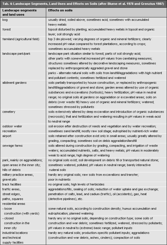
Table 4 gives results of human effects on soils. It orders the urban area into various soil association categories (anthric soil associations) under consideration of historic and current uses, damage to buildings in the Second World War, the type of construction, and the degree of sealing.