After 1918
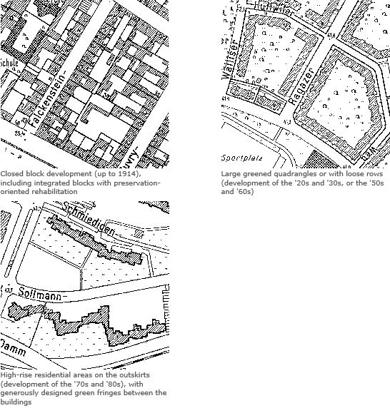
New designs developed extensively only after 1918, when the construction of wings and rear buildings was forbidden by law. At the same time, public housing construction companies took over from private builders the role as main actors in the area of residential construction. They replaced the until-then prevalent lot-by-lot development with the construction of larger, coherent subdivisions outside the Circle Line, in what was then the outskirts. This development was favored by the 1920 consolidation of Berlin with its surrounding communities to form Greater Berlin, which made uniform planning possible. Also, the open spaces associated with housing developments were accorded greater significance, which was manifest in the greater size, usefulness and design of these open spaces, but also in the designing of public open space. Later, the large public parks and allotment garden facilities emerged, which extended in a ring shape around the turn-of-the-century inner-city core.
After 1945
Massive destruction during World War II and the political division of Berlin in 1948 influenced the further course of urban development. Some 30 % of all buildings had been destroyed totally or severely damaged.
West Berlin
West Berlin received economic aid as part of the reconstruction program (Marshall Plan). As a result, the war-time destruction could be eliminated quickly by large-scale building activity during the fifties and sixties. In the inner city, vacant lots caused by the war were closed, and whole blocks were reshaped by large-scale reconstruction and by de-coring coupled with demolition and new building construction. The developmental goals were at that time the relief of the density of inner-city development and the dispersion of municipal functions. In the outskirts, large new self-contained subdivisions emerged with relatively high shares of open space, and with industrial areas on former open spaces between old village cores. During the seventies, construction policy concentrated on the revival of the inner city. Building activity was limited essentially to small vacant lots scattered throughout West Berlin, and on the preservation-oriented reconstruction of
existing structures.
East Berlin
In East Berlin, which received no economic support, but was, on the contrary, burdened by reparations, reconstruction began on a large scale only after construction of the Wall in 1961 and with the industrialization of the East Berlin construction industry. The emphasis during the sixties was on the recreation of the center of the city on areas wiped out and cleared as the result of the war. At that time, the long-term plan was to tear down the entire pre-war building stock everywhere as the inheritance of capitalism, and to replace it with developments built in the socialist architectural style. Relatively little new living space was created during the fifties and sixties. In 1971, therefore, the housing program was proclaimed as the main focus of the social program. The large satellite towns of Marzahn, Hellersdorf etc. were erected on the outskirts of town by means of industrial prefabrication. At the same time, the existing old-building stock was once again
considered living space worthy of preservation, and was rehabilitated with varying degrees of intensity.
After 1989
Altogether, approximately 150.000 apartments were built again in Berlin between 1991 and 2000. Approximately 60 percent of all reconstructions were erected as small supplements of the existing structure. Until 1992, the development with prefabricated houses situated in the east part of the city were completed. In the west part, only insignificant supplements were performed in this phase. 1993 to 1997 new suburbs in the outskirts were erected, like for example on former fields in Karow-Nord, as well as in downtown numerous big projects, like the Potsdam place or the government constructions. Since 1997, the housing reconstruction is retrograde in the entire conurbation and reached 2000 again the level of 1991 because of the reduction of finance supports. The construction of single houses is, after a maximum in the east districts and in the conurbation 1998 and 1999, also easily declining. Large parts of the city center with old buildings in the east part of the city were
reconstructed by government aid, like almost 80 percent of the settlements with prefabricated houses.
Open spaces
Remainders of agriculturally-used areas as well as landscapes characterized by water and forest have remained undeveloped to this day: These include the Köpenick Forest in the southeast of Berlin between the Spree and the Dahme, the Grunewald Forest in the west, along the Havel, as well as large intact agricultural areas in the northeast of the city. Some residential areas with their forest and orchard stands, such as the Uncle-Tom development in Zehlendorf, show signs of the previous landscape character of the area. Of the once-plentiful brooks, culverts and wet-lands, only a few can still be found.
Over the course of time, a multilayered structure of construction and open space has emerged in Berlin. On the present map, the various urban structural types are delimited and described. They are based on various area types, which are defined according to their typical use, time of origin and construction, and open-space structure. For reasons of representability, they have been grouped together into urban structural types.
The knowledge of these various structural types forms an essential basis of all urban development and landscape-planning standards, both at the local and at higher levels. However, this knowledge also permits information to be derived regarding the formation of biotopes and vegetation structures, climate relationships, condition of the soil, and the degree of soil impermeability, and the new formation of groundwater.