Depth to Groundwater 1995

Introduction

Groundwater levels in a metropolitan area like Berlin are subject not only to natural factors such as precipitation, evaporation and subterranean outflows, but are also strongly influenced by such human factors as development, sealing of surface, dewatering plants, withdrawals and returns.

The main factors of withdrawal include the groundwater demands of public water suppliers, private water production, and the lowering of groundwater levels at construction sites (cf. Map 02.11). Groundwater recharge is accomplished by precipitation, shore filtration, artificial recharge with surface water and returns of groundwater at construction sites.

In Berlin, there are two groundwater layers. The deeper layer carries salt water and is separated from upper groundwater layer by an 80 m thick layer of clay. The upper layer carries fresh water and has an average thickness of 150 m. It is the source of drinking (potable) and process (non-potable) water supply in Berlin. It consists of a variable combination of permeable and binding loose sediments. Sand and gravel (permeable soils) combine to form the groundwater aquifer, while the clay, silt and mud (binding soils) constitute a groundwater obstructing layer.

The upper surface of the groundwater is dependent on the (usually low grade) gradient of groundwater and the terrain morphology (cf. Fig. 1). The depth to groundwater is defined by calculating the perpendicular distance between the upper edge of the surface, and the upper surface of the groundwater. When the groundwater aquifer is covered by relatively impermeable, binding soil layers (groundwater obstructing layer), the groundwater is unable to rise enough to reach the height of its hydrostatic pressure. It is under these conditions that the groundwater level becomes confined. Only by drilling through the obstructing layer, is the groundwater able to rise on a level with the groundwater pressure area (Fig. 1).

Fig. 1: Depth to Groundwater Shown at Two Different Stages: Free and Confined

Fig. 1: Depth to Groundwater Shown at Two Different Stages: Free and Confined

The Map of Depth to Groundwater gives an overview of the spatial distribution of areas with the same depth classifications. Areas with a lower depth to groundwater (to about 4 m) are of particular importance. Pollution of soils can quickly lead to deterioration of groundwater in these areas, depending on the nature of the mantle (permeable or non-permeable) above the groundwater. The Map of Depth to Groundwater serves as a basic foundation for the preparation of the Map of Groundwater Vulnerability to Pollution. The spatial overlaying of groundwater depth onto geological characteristics of the covering mantle enables groundwater vulnerability to pollution to be differentiated (cf. Map 02.05).

Knowledge of groundwater depths enables an estimatione of groundwater influence on vegetation. The influence of groundwater on vegetation depends on the root depths of plants and, according to soil type, the capillary climbing capacity of groundwater. The threshold depth at which groundwater can be used by trees is given at 4 m for general Berlin conditions. Vegetation in wetlands depends mostly on groundwater and requires a depth to groundwater of less than 50 cm.

Groundwater level in the city is subject to diverse man-made influences. The first lowering of the groundwater level and the destruction of wetlands in the Berlin area, was the dewatering of swampy areas like the Hopfenbruch in Wilmersdorf in the 18th century. The 19th and 20th centuries saw the dewatering of other areas by the construction of canals. The groundwater level was further lowered by the increasing demand for drinking and process water, and by restrictions on groundwater recharge caused by surface sealing.

Up until the end of the 19th century, the mean groundwater level in Berlin was subject only to the yearly fluctuation in precipitation. The period between 1890 and the end of the Second World War was marked by rapid urban growth, the construction of rail networks (Alexanderplatz), and by major reconstruction projects. Because of the construction, the groundwater level in the inner city was dramatically lowered, resulting in the 8 m drop of the groundwater level. With the breakdown of the public water supply at the end of the war, the depth of groundwater was able to restore itself to naturally levels (Fig. 2).

Fig. 2: Fluctuation of Groundwater Levels at Measuring Site 5140 in Mitte (Charlottenstrasse) since 1870

Fig. 2: Fluctuation of Groundwater Levels at Measuring Site 5140 in Mitte (Charlottenstrasse) since 1870

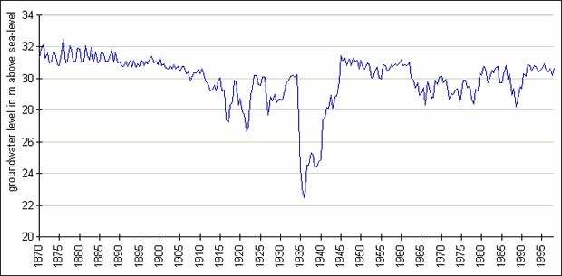
In the following period, from the beginning of the 50’s to the beginning of the 80’s, the groundwater level sank continually and over large areas because of increasing withdrawals. This trend was particularly noticeable in water production areas (waterwork facilities). This lowering was caused by the general rise in water consumption by private households, and by construction (the rebuilding of the heavily destroyed city, subway construction, and massive construction projects). The expansion of water production facilities in West Berlin waterworks was completed by the beginning of the 70’s. The enlargement of the Friedrichshagen Waterwork in East Berlin began in the mid-70’s to supply water to the new residential areas in Hellersdorf, Marzahn and Hohenschönhausen.

A slight rise of groundwater levels has occured in West Berlin since the end of the 70’s.

A range of reasons can be given for this rise: smaller withdrawals from private wells; smaller withdrawals at construction sites (smaller construction volume and enforcement of groundwater returns); smaller withdrawal volumes of public waterworks; and, not least, effective man-made groundwater recharging (cf. Map 02.11).

Following the political changes in 1989 (fall of the Berlin Wall), the level of water consumption in the eastern boroughs of Berlin was drastically reduced, and the production at the waterworks in those areas fell an estimated 50 %. This resulted in the rise of the groundwater level throughout the city, east and west. Those areas nearest to waterworks recorded level increases as high as 3 m. The Berlin Pleistocene Watercourse, which covers half the area of the city, anyway has a very low depth to groundwater of only a few meters. Many of the cellars in some areas were not constructed according to code, therefore the sudden increase in groundwater caused major damage from flooding. In two areas, the damage was so extensive that it was necessary to implement groundwater regulatory measures. In Rudow within the catchment area of the Johannisthal Waterwork the groundwater level was lowered by a well gallery. Near the Kaulsdorf Waterwork, it is planed to regulate the groundwater by lowering the lake level in the Kaulsdorfer Seen (lakes).

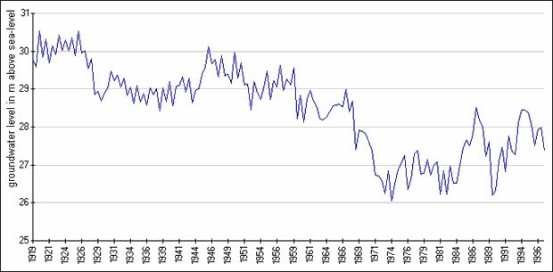
Permanent, wide and deep cones of depression have formed in water catchment areas around waterwork extraction wells. The considerable differences seen among the groundwater levels are directly related to variations in extraction demands at the waterworks. Riemeistersee (see=lake) and Nikolassee were dried out by water withdrawals of the Beelitzhof Waterwork at the beginning of this century. The groundwater level at Schlachtensee fell by 2 m, and at Krumme Lanke by 1 m. Water from the Havel has been pumped into the Grunewaldseen (inversion of natural flow) to balance this loss since 1913. The wetlands of Hundekehlefenn, Langes Luch and Riemeisterfenn, as well as the shore areas of the lakes were saved by this measure.

The cones of depression around well galleries at the Havel Lake have effects deep into the Grunewald (forest). The groundwater level at Postfenn sank 3.5 m between 1954 and 1974, and at Pechsee in Grunewald about 4.5 m between 1955 and 1975. Well gallery withdrawals at banks of the Havel cause severe drying of root soils of plants in the direct vicinity of the Havel.

About 90 % of the wetlands around the Müggelsee in southeast Berlin are threatened (Krumme Laake, Müggelheim, Teufelsseemoor, Neue Wiesen/Kuhgraben, Mostpfuhl, Thyrn, the lower course of Fredersdorfer Fliess).

Some wetland areas were flooded and given seepages of surface water to moderate negative effects caused by lowering of groundwater levels. These were the West Berlin nature reserves Grosser Rohrpfuhl and Teufelsbruch in the Spandau Forest, and Barssee in Grunewald; in East Berlin, Krumme Lake in Grünau and Schildow in Pankow.

Large-area lowering of groundwater levels occured in the Spandau Forest also, caused by the higher withdrawals by the Spandau Waterwork since the 70’s. A groundwater recharge plant, operated since 1983, percolates purified Havel water in an attempt to gradually raise groundwater levels. The groundwater level in the Spandau Forest was raised an average of 0.5 – 2.5 m by May, 1987. Groundwater recharge in this area has been restricted again because water appeared in cellars of near-by residential areas. The simultaneously rising withdrawal amounts of the Spandau Waterwork lowered the groundwater level again since 1990. In the following period, the groundwater level rose once more, due to the further reduction of withdrawal amounts.

Fig. 3: Fluctuation of Groundwater Levels at Measuring Site 1516 in Spandau Forest

Fig. 3: Fluctuation of Groundwater Levels at Measuring Site 1516 in Spandau Forest