Green Roofs 2020

Methodology

The method that was developed for acquiring data on green roofs consists of two steps:

  • an automated preliminary mapping, including the determination of reference areas, and
  • a review and correction of the preliminary mapping results by interpreting aerial images (visual post-processing).

The following diagram shows the details of the workflow. A comprehensive description of the procedure may be found in the final report (Pauligk & Stöckigt 2022).

Fig. 1: Workflow – capturing data on the green roof inventory in the State of Berlin, 2020

Automated preliminary mapping

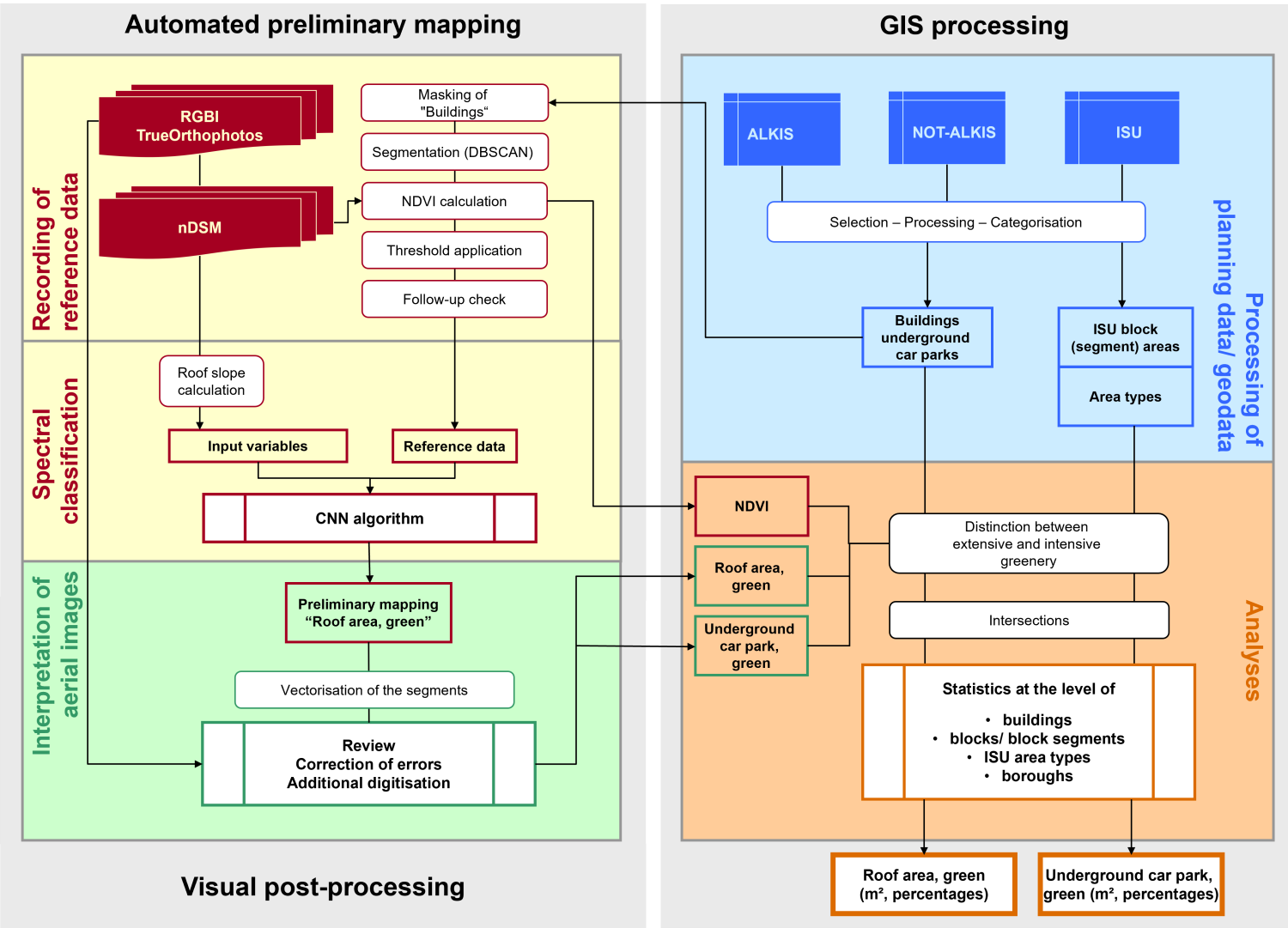
As part of the automated preliminary mapping, a supervised classification was carried out to predict the location of green roofs. For this, detailed reference data had to be recorded for a section of Berlin (~2,000 ha). The process of deriving this reference data was based on building outlines, which defined the areas for analysis, i.e. only these areas were searched for vegetation. Buildings that were not listed in the data bases (ALKIS, NOT-ALKIS) were not analysed. A combination of unsupervised classification and threshold analysis, using the Normalised Difference Vegetation Index (NDVI), was found to be a suitable approach for detecting green roofs within the analysed areas.

Initially, density-based clustering (DBSCAN) was applied to the areas within building outlines that were analysed. DBSCAN is an unsupervised algorithm that groups pixel values together within a feature space, based on their spatial proximity, therefore dividing them into segments. In addition to the spectral data of the TrueOrthophoto, the object height (nDSM) was also factored into the analysis. The segments were then characterised by their NDVI. An average NDVI of more than 0.1 led to a preliminary detection of a green roof. The NDVI is a synthetic channel that combines information from the near-infrared (NIR channel) and the red spectrum (red channel), which highlights vegetation areas in particular. Numerous studies found that this additional channel was useful for differentiating between surfaces with and without vegetation, and for classifying degrees of impervious coverage (Coenradie et al. 2021, Coenradie & Haag 2016a). As the section used for deriving reference data was rather small (~2000 ha), the preliminary detection of green roofs were adjusted easily, based on a visual correction. The corrected data was then used as an accurate reference in the supervised classification.

A Convolutional Neural Network (CNN) was used for the supervised classification. It is a type of neural network that has become popular in the classification of image data, as its prediction also considers spatial structures within the image in addition to the spectral signature (Kattenborn et al. 2021). One of the most widely used CNN architectures is the U-Net, which was also used to detect green roofs in this project (Ronneberger et al. 2015). In addition to the reference data described, the supervised classification also requires relevant input variables. These include the spectral bands of the orthophoto, the normalised Digital Surface Model (nDSM) and the slope of the roof surface derived from the latter. After training the algorithm, the model was applied to the rest of the area to be investigated, which simplified the subsequent mapping process. Due to the high data requirements of neural networks and the rather small data pool of derived reference data, post-processing 
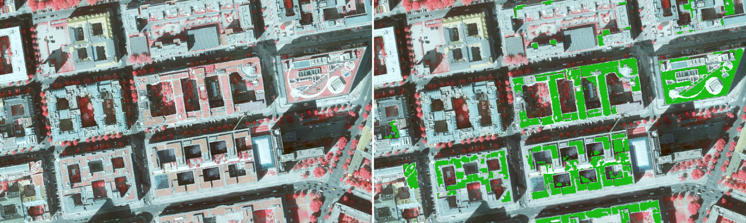
was an essential part of the workflow. Fig. 2 presents the prediction of the model for a small sample area.

Fig. 2: Supervised classification results, left: TrueOrthophoto, 2020; right: automated preliminary mapping of the green roof inventory (green)

Visual post-processing

The intermediate results of the automated preliminary mapping were reviewed and corrected based on aerial images.

The interpretation and mapping process was based on the following rules:

  • All vegetated roof areas count as green roofs, regardless of whether they were deliberately designed as green roofs (which cannot always be discerned) or came about due to spontaneous vegetation.
  • Large plant tubs and roof gardens are mapped as green roofs.
  • Pre-mapped areas are the main focus of the review; large green roofs that were missed are then digitised upon detection.
  • If a green roof area also includes a solar system, it is still recorded as a green roof area in its entirety.
  • The recording of a green roof is considered sufficient if more than two thirds were detected during the preliminary mapping process. In this case, no post-processing is necessary. If less than two-thirds of a green roof were mapped, the green roof is digitised manually, based on the exact areas.
  • If a green roof may not be discerned due to shadows or a canopy cover (this mainly concerns garage roofs), any preliminary mapping is deleted. This does not apply to roof areas overshadowed by trees, for which a green roof was detected in 2016. In these cases, TrueOrthophotos from February 2021 are reviewed. If a green roof is discernible at the point when trees are without foliage, it is mapped subsequently.
  • Very narrow linear elements or paths do not need to be excluded.

After all areas were reviewed, those green roofs with green areas of more than 10 m² per building were selected. This allowed for individual pixels and tiny areas to be included; it is the total area per roof that was important in the end. If a roof had a green roof area of less than 10 m², it was deleted. Subsequently, the green roof areas were divided into intensive (NDVI >0.162) and extensive areas (NDVI <= 0.162) using an NDVI threshold. Depending on the category share of the green roof (> 50 %), the entire roof was either categorised as an ‘intensive’ or ‘extensive’ green roof. An intensive green area is characterised by dense and vital vegetation. An extensive green area is characterised by sparser and possibly drier vegetation.

The information was linked to additional geodata. Based on this, the following result layers could be established, which may also be accessed in the Geoportal:

  • green roof area (intensive/ extensive),
  • building floor area and
  • block (segment) area of the ISU with data on greenery.