New Groundwater Formation 1990

Methodology

The amount of new groundwater formation was calculated from the percolation rates according to the methodology suggested by Glugla (Glugla & Fürtig, 1997, Glugla & Müller, 1997, Glugla & Eyrich, 1993, Glugla & König, 1989, Glugla et al., 1999). According to Glugla (see above), for open aquifers, such as the glacial spillways and outwashes of northern Germany, the new groundwater formation corresponds to the percolation water formation; there, the following applies:

GWNB = Ri = P – Eta – Row

where

GWNB = new groundwater formation

Ri = percolation water formation

P = long-term mean annual precipitation sums

Eta = long-term mean actual evapotranspiration

Row = long-term mean surface runoff

However, in areas with covered aquifers, e.g. the ground moraines with glacial till or loam, only a part of the percolation water formation reaches the groundwater. In these areas, a part of the percolation water is carried away as near-surface interflow into bodies of water (receiving streams). Surface runoff and interflow together constitute the mean runoff MQ to the receiving streams. In areas with covered aquifers, the new groundwater formation can therefore be derived from the difference between the calculated total runoff formation (R = P – Eta) and the actual runoff MQ to the receiving streams which drain the area. In these areas, the following applies:

GWNB = Ri – Rzw

GWNB = P – Eta – Row – Rzw

GWNB = P – Eta – MQ

where

GWNB = new groundwater formation

Ri = percolation water formation

P = long-term mean annual precipitation sums

Eta = long-term mean actual evapotranspiration

Row = long-term mean surface runoff

Rzw =long-term mean interflow

MQ =mean runoff to the receiving streams ( = Row + Rzw)

Data on mean runoff to receiving streams in the catchment areas and their segments are an important basis for the calculation of new groundwater formation in areas with covered aquifers. These data are, however, only partially available. The data situation for the application of the method for the area of the State of Berlin must be considered difficult. Nevertheless, the method suggested by Glugla permits altogether plausible new groundwater formation rates to be calculated from the runoff and percolation water formation data.

For the determination of new groundwater formation rates, areas with covered and open aquifers were first distinguished, for only for the areas with covered aquifers does the new groundwater formation differ from the percolation water formation. The areas with covered aquifers were essentially derived from the Digital Map for the Characterization of Overburden, according to WRRL (SenStadt, 2002). Furthermore, all mapped areas with confined groundwater (p. Map 02.07) which extend beyond the areas of the above-mentioned map represented as “groundwater overburden” were certified as covered. Fig. 5 shows the areas distinguished for the determination of new groundwater formation rates according to open or covered aquifers.

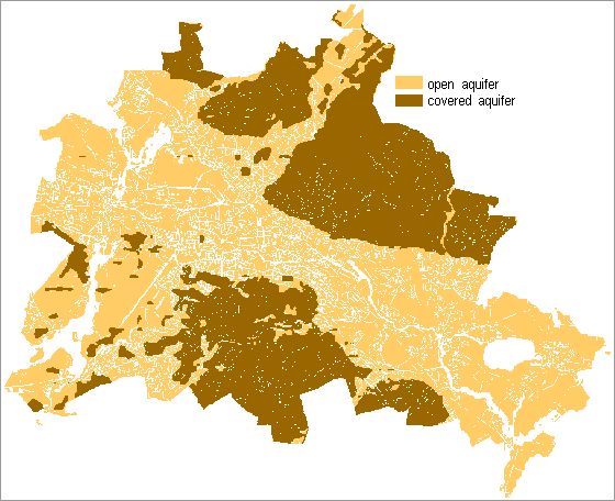
Fig. 1: Areas with covered and open aquifers

Fig. 1: Areas with covered and open aquifers

The contiguous, covered areas certified here are essentially the Barnim and Teltow ground moraines. The Warsaw-Berlin glacial spillway and the larger valley lowlands of the Barnim, particularly the Panke valley, are essentially areas with open aquifers, except for single islands with cohesive substrata. Large contiguous areas with open aquifers are also present in the area of the plateau sands of the Teltow plateau and the Nauen plate. In terms of the area of the State of Berlin, the area with open groundwater (518 km²) outweighs that with covered aquifers (335 km²).

In another processing stage (SenStadt Data Base, 2003), the catchment areas of the receiving streams were delimited in those areas with covered aquifers. To the extent available, runoff measurements from watermark gauges at the receiving streams were assigned to these catchment areas. From the long-term mean runoff MQ and the size of the catchment associated with it, the average annual influx (sum of surface and interflow runoff) into the respective receiving stream was ascertained. The problems here were on the one hand the frequently insufficient data (e.g. for the Teltow plateau), and on the other, the fact that measured runoffs are characterized by influx from sewage plants and pipelines, and by the often very high degree of sealing, and thus only partially reflect natural runoff behavior. For these reasons the runoffs measured to receiving stream generally permit statements of only limited accuracy.

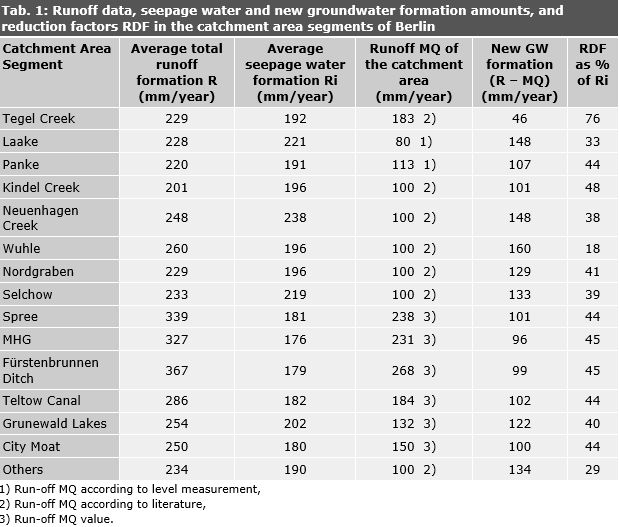
Due to this very heterogeneous database, three cases had to be distinguished (cf. Table 1) for the runoff data to the receiving streams:

  • Case 1: there are runoff values measured at watermark gauges;
  • Case 2: no data are available from measurements; hence, additional data were evaluated from the literature (Glugla & Müller, 1997);
  • Case 3: neither measured runoff data nor references from the literature were available.
    In Case 3, an assumable mean runoff was assessed for the covered catchment areas which show very high surface runoff due to strong sealing. An interflow of 80 mm/year was accepted in these areas. The mean runoff was calculated from the sum of the assumed interflow and the surface runoff according to Map 02.13.1 of the Environmental Atlas for block sections within a catchment area.

Values for Cases 2 and 3 in Table 1 therefore merely show benchmark values.

On the basis of the method of Glugla (Glugla & Fürtig, 1997, Glugla & Eyrich, 1993), the share of the runoff formation of each of the delimited catchment areas which was led off as surface and lateral or interflow runoff into the receiving stream and therefore did not contribute to new groundwater formation was calculated using this database. Moreover, there is the fundamental problem that parts of the catchment areas runoff to the receiving stream are outside the area of the state of Berlin and no appropriately detailed runoff data from these areas were available for the process. However, since the geological and climatic relationships of the catchment areas observed do not differ fundamentally inside and outside the state boundary of Berlin, the available runoff data from Berlin have also been taken as representative for the shares of the catchment areas outside Berlin. A reduction factor for the calculation of new groundwater formation from the percolation water formation was then derived for every catchment area from the relationship of runoff and percolation water, respectively, and the sum of surface and interflow runoff (see Tab. 1).

The calculation process will be explained briefly here by way of the example of the Tegel Creek catchment area: The calculated average total runoff formation R in this catchment area is 229 mm/yr. (section-weighted mean of the total runoff from precipitation for all block sections in this catchment area, according to Map 02.13.3 of the Environmental Atlas). The average percolation water formation Ri (section-weighted mean of the percolation from precipitation of all block sections in this catchment area according to Map 02.13.2 of the Environmental Atlas) is 192 mm/year. Surface runoff is thus 229 mm/yr. – 192 mm/yr. = 37 mm/yr. However, Tegel Creek, which drains this catchment area, shows a real mean runoff MQ of 183 mm/yr. This mean runoff MQ includes the surface runoff (37 mm/yr.) and the interflow (183 mm/yr. – 37 mm/yr. = 146 mm/yr.). The average new groundwater formation is calculated from the difference between the average total runoff formation R (229 mm/yr.) and the mean runoff MQ (183 mm/yr.). It is 46 mm/yr. in this area, i.e. it is reduced by 76 % compared with the percolation water rate; hence, only 24 % of the percolation water quantity is effective in new groundwater formation. Thus, the new groundwater formation is very substantially lower than the average percolation water formation in this area.

This reduction of the percolation water rate for the determination of new groundwater formation was carried out analogously for the other catchment areas (reduction factor “RDF referenced to Ri” in Table 1 for the exemplary area of Tegel Creek = 76 % ). For the calculation of new groundwater formation rates broken down by block section, the percolation water rate of every single block section was reduced by the reduction factor RDF for the catchment area, i.e. for the example of Tegel Creek, by 76 %.

Tab. 1: Runoff data, percolation water and new groundwater formation amounts, and reduction factors RDF in the catchment area segments of Berlin

Tab. 1: Runoff data, percolation water and new groundwater formation amounts, and reduction factors RDF in the catchment area segments of Berlin