Groundwater Levels of the Main Aquifer and Panke Valley Aquifer 2010
Introduction

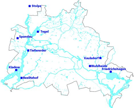
Exact knowledge of the current ground-water levels, and hence also of groundwater stocks, is imperative for the State of Berlin, since 100% of the drinking-water supply (approx. 204 million cu.m. in 2009) is obtained from groundwater. This groundwater is pumped at nine waterworks, almost entirely within the territory of the city. Only the Stolpe Waterworks on the northern outskirts obtains water from Brandenburg, but also supplies Berlin with approx. 9 % of the city’s total intake (Fig. 1).

Fig. 1: Location of the nine waterworks which supply Berlin with drinking water, as of May 2010

Fig. 1: Location of the nine waterworks which supply Berlin with drinking water, as of May 2010

Moreover, groundwater reserves are tapped for individual use and for process water, as well as for major construction projects, groundwater rehabilitation measures and heating-related purposes. Numerous instances of soil and groundwater contamination are known in Berlin, and they can only be rehabilitated on the basis of exact knowledge of groundwater conditions.

For this reason the Geology and Groundwater Management Working Group produces a map of ground-water levels every month. The map from may, the month with normally the highest groundwater level, is published in the Environmental Atlas.

Definitions Regarding Groundwater

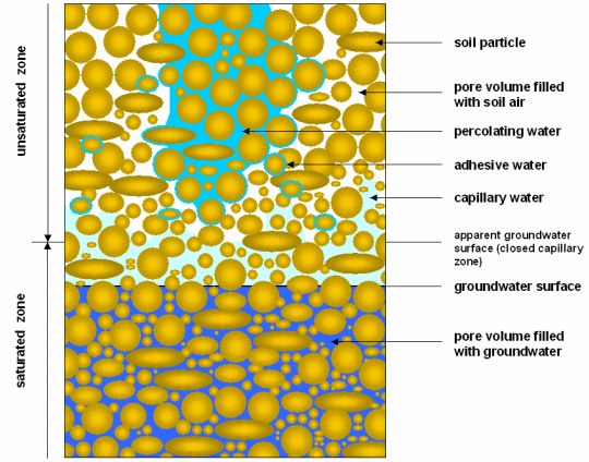
Groundwater is underground water (DIN 4049, Part 3, 1994) which coherently fills out the cavities in the lithosphere, and the movement of which is caused exclusively by gravity. In Berlin, as in the entire North German Plain, the cavities are the pores between the soil particles in the loose sediments. Precipitation water which percolates (infiltrates) into the ground first fills these pores. Only that part of the percolating water which is not bound as adhesive water in the non-water-saturated soil, nor used up by evaporation, can percolate to the phreatic surface and form groundwater. Above the phreatic surface, capillary water is present within the unsaturated soil zone; it can rise to various heights, depending on the type of soil (Fig. 2).

Fig. 2: Phenomenology of Underground Water

Fig. 2: Phenomenology of Underground Water

Aquifers are made of sands and gravels, and, as incoherent material, make the storage and movement of groundwater possible.
Aquitards consist of clay, silt, gyttja and glacial till and, as cohesive material, hinder water movement.
Aquicludes are made of clay which is virtually impermeable to water.

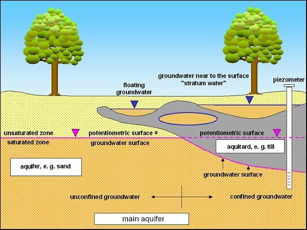
Groundwater the phreatic surface of which lies within an aquifer is known as free or unconfined groundwater, i.e., the phreatic and piezometric surfaces coincide. In cases of confined groundwater however, an aquifer is covered by an aquitard so that the groundwater cannot rise as high as it might in response to its hydrostatic pressure. Under these conditions, the piezometric surface is above the phreatic surface (Fig. 3).

If an aquitard, such as a glacial till, is located above a large coherent aquifer (main aquifer), surface-proximate groundwater may develop in sandy segments above the aquitard and in islands within it, as a result of precipitation. This is unconnected with the main aquifer, and is often called stratum water. If an unsaturated zone is located below the glacial till, it is called floating groundwater (Fig. 3).

Fig. 3: Hydrogeological Terms

Fig. 3: Hydrogeological Terms

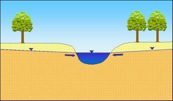
As a rule, groundwater flows at a slight incline into rivers and lakes (receiving bodies of water) and infiltrates into them (effluent conditions; Fig. 4a).

Fig. 4a: Groundwater infiltrates into bodies of water

Fig. 4a: Groundwater infiltrates into bodies of water

In times of flood, the water surface is situated higher than the groundwater surface. During such periods, surface water infiltrates into the groundwater (influent condition). This is known as bank-filtered water (Fig. 4b).

Fig. 4b: Bank-filtered water caused by flood water: surface water infiltrates into groundwater

Fig. 4b: Bank-filtered water caused by flood water: surface water infiltrates into groundwater

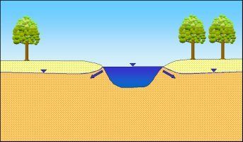
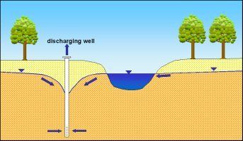
If in the neighborhood of these surface waters, groundwater is discharged, e.g. through wells, so that the phreatic surface drops below the level of that body of water, the body of water will also feed bank-filtered water into the groundwater (Fig. 4c).

Fig. 4c: Bank-filtered water caused by discharge of groundwater: due to the drop in the groundwater caused by wells, surface water infiltrates into the groundwater

Fig. 4c: Bank-filtered water caused by discharge of groundwater: due to the drop in the groundwater caused by wells, surface water infiltrates into the groundwater

The groundwater velocity of flow in Berlin is approx. 10 to 500 m p/a, depending on the groundwater incline and the permeability of the aquifer. However, near well facilities, these low-flow velocities can increase significantly.

Morphology, Geology and Hydrogeology

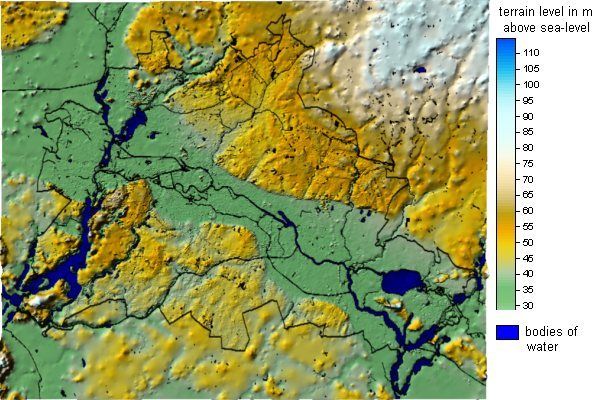
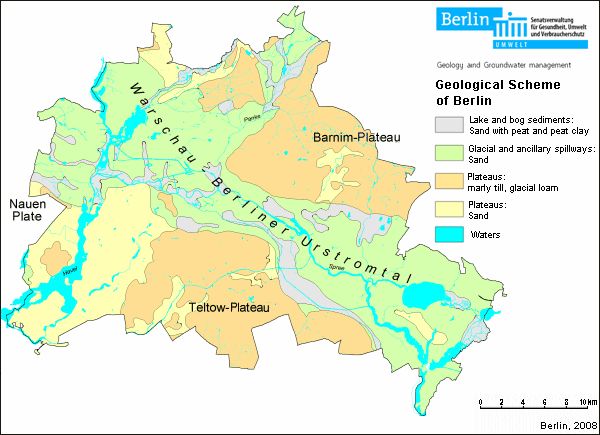
The present shape of the earth’s surface in Berlin was predominantly the result of the Vistula Ice Age, the most recent of the three great quaternary inland glaciations. The most important morphological units are the Warsaw-Berlin Glacial Spillway, with its Panke Valley branch, consisting predominantly of sandy and gravel deposits; the neighboring Barnim Plateau to the north; and the Teltow Plateau with the Nauen Plate to the south, which are covered in large part by the thick glacial till and boulder clay of the ground moraines (Fig. 5 and 6).

Fig. 5: Morphological Outline Map of Berlin

Fig. 5: Morphological Outline Map of Berlin

Fig. 6: Geological Outline Map of Berlin

Fig. 6: Geological Outline Map of Berlin

The loose sediments dating from the quaternary and tertiary, and averaging approx. 150 m in thickness, are of special significance for the water supply and for foundation of buildings. They form the freshwater stock from which Berlin draws all the drinking water and a large part of the process water. Numerous waterworks an other pumping facilities have lowered the groundwater in Berlin partly since more than 100 years.
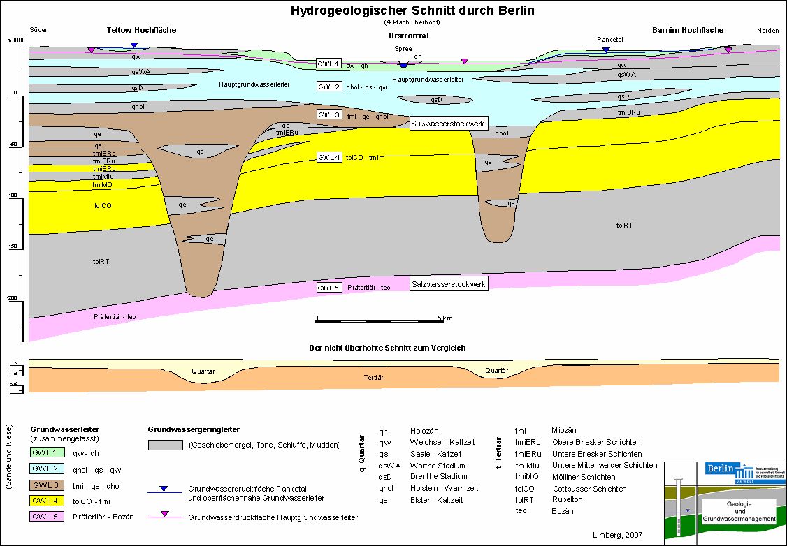
The tertiary rupelium layer in a depth of 150 to 200 m is about 80 m thick, and constitutes a hydraulic barrier against the deeper saltwater tier (Fig. 7).

Fig. 7: Schematical Hydrogeological Cross-Section of Berlin from South to North

Fig. 7: Schematical Hydrogeological Cross-Section of Berlin from South to North

Due to the alternation of aquifers (green, blue, brown and yellow in Fig. 7) and aquitards (grey in Fig. 7), the freshwater stock in the Berlin area is broken down into four separate hydraulic aquifers (Limberg, Thierbach 2002). The second aquifer, which is largely a Saale-glaciation-era aquifer, is known as the main aquifer, since it supplies the predominant share of the drinking and process water. The fifth aquifer is in the saltwater tier under the rupelium.

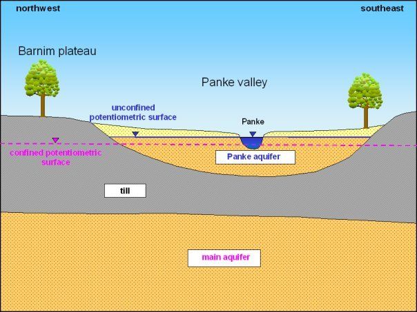
The groundwater conditions of the main aquifer (Aquifer 2) are shown in the groundwater contour map in violet; in the Panke Valley aquifer (Aquifer 1) in the northwestern area of the Barnim Plateau, they are shown in blue. Here, the Panke Valley aquifer is situated above the main groundwater aquifer, separated from it by the glacial till of the ground moraine (Fig. 7 and 8).

Fig. 8: The unconfined Panke Valley aquifer (Aquifer 1) in the northwestern area of the Barnim Plateau is situated above the main aquifer (Aquifer 2), which is confined in this area

Fig. 8: The unconfined Panke Valley aquifer (Aquifer 1) in the northwestern area of the Barnim Plateau is situated above the main aquifer (Aquifer 2), which is confined in this area

In the northwestern area of the Barnim Plateau, the ground moraines are so thick that no main groundwater aquifer exists, or occurs only in isolated places, with a thickness of a few meters. For those areas of the Berlin city area, no groundwater contours can be shown.