Planning Advice for Soil Protection 2015

Methodology

Differentiated Assessment of Soil Functions

In order to solve the two tasks of developing a differentiated assessment of soil functions, and implementing this soil-function assessment to create Planning Advices, the following thought processes and work steps have been implemented in Map 01.13:

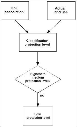
First of all, the soil functions (Maps 01.12.1 through 01.12.5) have been weighted differently, according to their significance depending on the specific conditions in Berlin (cf. Gerstenberg et al., 2007 and 2015 for more detail):

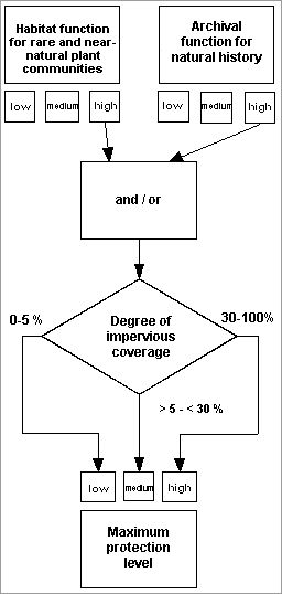
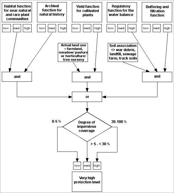
  • It is deemed extremely important to protect soils functioning as archives and soils which constitute potential sites for rare and near-natural plant communities, as these soils cannot be restored.
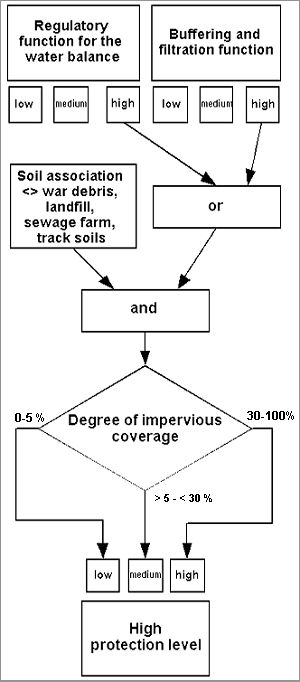
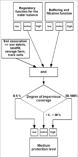
  • In general, it is important to protect soils with a high regulatory function for the water balance and buffering and filtration function. This importance increases further at these locations if both functions occur and are rated as “high”.

It is important to sustain soils with a high yield function for cultivated plants in areas that are used for agriculture.

This establishes a prioritization regarding the importance and vulnerability of soil functions.

Moreover, soils with clear potential for material contamination (e.g. sewage farms) with regard to their regulatory, filtration and buffering functions as well as their yield function for cultivated plants are excluded from the assessment, as they are a potential source of contamination for the groundwater and the food chain.

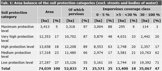
To assess soils in terms of their level of protection, five protection categories have been established, ranging from the maximum to the lowest protection status. These may be used to derive strategies for action and recommended strategies in the event of soil interventions due to planning and construction projects.

The following soil protection categories are distiniguished to represent the protection level of soils:

  • maximum protection level,
  • very high protection level,
  • high protection level,
  • medium protection level and
  • low protection level (soils without special requirements).

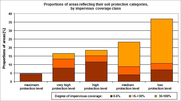
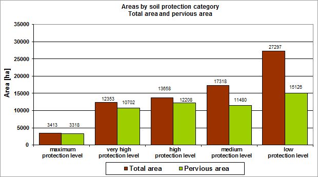
All information and assessments presented here relate to pervious soils, as is the case for all Environmental Atlas maps covering soil as a topic, with the exception of the map on impervious soil coverage. The extent of impervious coverage is of great importance, however. The degree of impervious coverage is therefore not only presented in the factual data display but is also reflected by different colour shades. There are three different colour shades; with decreasing impervious coverage, the colour intensity of the protection category also decreases.

Five % and 30 % were chosen as thresholds to separate the different levels of impervious coverage: areas with a level of impervious coverage of 5 % or less can be considered completely pervious, interrupted only by scattered buildings, pathways etc. This includes forests, farmland and meadows and pastures. Allotment gardens, single-family homes, park facilities and other open spaces, which may also still have near-natural soils, prevail in the “medium” category with an impervious coverage level of between more than 5 % and less than 30 %. Impervious coverage that is greater than 30 % occurs primarily in residential and commercial areas, and in traffic areas, where no natural soil associations remain to a large extent.

Maximum protection level

This category is linked to high ratings for the “habitat function for rare and near-natural plant communities” and/or for the “archival function for natural history.”

This category is associated with the maximum protection status and covers only approx. 5 % of the area evaluated. With respect to possible planning, there are special requirements in regard to considering alternative sites and avoiding interventions. This is the case, as it is virtually impossible to restore the habitat function for rare and near-natural plant species, and definitely impossible to restore the archival function for natural history (Smettan & Litz 2006). Therefore, projects or plans which definitely require interventions in soils with the maximum protection level must be authorized in collaboration with the soil protection authority (Leitbild und Maßnahmekatalog (Catalogue of models and measures), 2015, only in German).

Fig. 1: Diagram to assign the category “maximum protection level”

Fig. 1: Diagram to assign the category “maximum protection level”

Very high protection level

The category “Very high protection level” is based on several assessment factors:

  1. The “habitat function for rare and near-natural plant communities” as well as the “archival function for natural history” was assessed as medium, or
  2. the “yield function for cultivated plants” was assessed as high on areas with agricultural use (farmland, meadows and pastures or tree nursery / horticulture), or
  3. the “regulatory function for the water balance” as well as the “buffering and filtration function” were assessed as high.

The majority of the areas in this protection category have been assigned to it due to their habitat and archival functions, a slightly smaller share due to their regulatory or buffering and filtration functions, with only a few areas having been assigned to it because of their yield function for cultivated plants.

The area category “Very high protection level” means that, for reasons of soil protection, avoiding planned interventions should be prioritized, or suitable alternative sites should be sought in keeping with other requirements. Moreover, net loss of pervious soil and soil functions are not permissible.

Fig. 2: Diagram to assign the category "very high protection level"

Fig. 2: Diagram to assign the category "very high protection level"

High protection level

The category “High protection level” is linked to a high rating for the “regulatory function for the water balance” or for the “buffering and filtration function.

The protection status is lower here, as compared with the “Very high protection level”, due to the clear drop in the number of soil functions involved. It is sufficient that only one criterion (either the regulatory function for the water balance or the buffering and filtration function) is rated as high. Despite the lower protection level, an effort should also be made here to avoid or compensate for a net loss of land and soil functions, in collaboration with the soil protection authority (Leitbild und Maßnahmekatalog (Catalogue of models and measures), 2015, only in German).

Fig. 3: Diagram to assign the category "high protection level"

Fig. 3: Diagram to assign the category "high protection level"

Medium protection level

The category “Medium protection level” is linked to medium ratings both for the “regulatory function for the water balance” and the “buffering and filtration function.

If the functions in question occur as described, they can potentially be improved with technical measures, such as the retention of precipitation water or the use of soil coverage pervious to water and air. The focus here is thus on avoiding a net loss of soil functions and keeping the net loss of land as low as possible in collaboration with the soil protection authority (Leitbild und Maßnahmekatalog (Catalogue of models and measures), 2015, only in German).

Fig. 4: Diagram to assign the category "medium protection level"

Fig. 4: Diagram to assign the category "medium protection level"

Low protection level (soils without special requirements)

The remaining soils are assigned to the category “Low protection level.”

Here, the general legal soil protection requirements (Federal Soil Protection Law 1998, Federal Soil Protection and Residual Waste Ordinance 1999, Berlin Soil Protection Law 2004, Building Code 2017, Leitbild und Maßnahmekatalog (Catalogue of models and measures), 2015, only in German) apply.

Fig. 5: Diagram to assign the category "low protection level"

Fig. 5: Diagram to assign the category "low protection level"

Fig. 6: Proportions of areas reflecting their soil protection categories, by degree of impervious coverage (excl. streets and bodies of water)

Fig. 6: Proportions of areas reflecting their soil protection categories, by degree of impervious coverage (excl. streets and bodies of water)

Fig. 7: Total area and pervious area by soil protection category

Fig. 7: Total area and pervious area by soil protection category

Fig. 8: Proportions of areas and their uses by soil protection category

Fig. 8: Proportions of areas and their uses by soil protection category

Tab. 1: Area balance of the soil protection categories (excl. streets and bodies of water)

Tab. 1: Area balance of the soil protection categories (excl. streets and bodies of water)

Advice for Implementation in Planning Practice

The planning advice for soil protection comprises requirements and stipulations relevant for each soil protection category. Although they are intended for development planning, their meaning can be transferred and applied to other types of spatial projects and planning. For methodological reasons, the advice is represented in the map legend in very general form only. Detailed information, available in tabular form for each area, can be accessed using the factual data display of the FIS Broker. The terms used here, such as “avoidance” and “compensation” are not legal terms but represent technical measures of soil protection. To reiterate in this context, the soil functions assessed refer only to pervious block segments.

The factual data display includes the soil protection category, the soil association and land use relevant for the assessment, the ratings for each of the five soil functions (from Maps 01.12.01 through 01.12.05) as well as the degree of impervious coverage. The planning requirements table, which can be displayed separately for each area, is of particular interest, however.

Structure and contents of the planning requirements table:

  • Line 1 states the soil protection category.
  • Line 2 states the general soil protection goal.
  • Line 3 describes the reasons for the classification (cf. “Methodology Item 1”) in short form. The statements in the additional lines are based on these characteristic soil functions.
  • Line 4 details avoidance and reduction measures that should generally be pursued. No distinction has been made between avoidance and reduction, since the assignment depends on the context and the point of view of the parties involved. What matters here is that soils are protected from intervention, if they are deemed worthy of protection. Terminology is secondary only.
  • Line 5 presents suggestions for compensatory measures, focusing on function as far as possible. First, those requirements are named which can be determined conditionally in accordance with the provisions of the Building Code.
  • Line 6 contains additional measures in some cases, which are useful to compensate for considerable impairments of soil functions under the aspect of soil protection.
  • Line 7 contains other notes and explanations.
Table 2: Example of a planning requirements table

Table 2: Example of a planning requirements table