As agreed, the loose rock occurring in the North German Plain is depicted to a depth of 2 m. The material at deeper levels, the geological structure and the deposit conditions and disturbances can be obtained from the profile sections and the explanatory text.
The representation of the various units in the geological outline is carried out for the surface to a depth of 2 m, and 5 m in exceptional cases. If various different layers occur in this stratum, e.g. sand over glacial till, only the dominant layer is shown here, for the sake of simplicity; in this case, that would be the till.
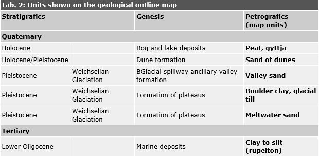
Table 2 shows the compiled geological units, distinguished according to stratigraphics (age, chronological sequence), genesis (origin) and petrographics (description of rock).