Water Conservation Districts 2009

Introduction

Berlin’s drinking water needs are met primarily by groundwater. The drinking water supply is managed by the Berlin Waterworks (BWB). Water supplies are to some extent obtained as bank filtered water: surface water filters through the soil and is withdrawn by extraction wells near the shore. Some surface water is diverted into groundwater recharge plants to percolate into the groundwater, which is then withdrawn for use.

Fig. 1: Principles of groundwater production

Fig. 1: Principles of groundwater production

There are also a number of smaller waterworks, the private sector water supply plants, which withdraw groundwater for private sector purposes, mostly industrial, or withdraw groundwater for public facilities.

Construction activity in Berlin increased considerably after the unification of the city in 1990. Groundwater retention is practiced during construction, in which groundwater is withdrawn. Depending on the level of construction activity, this occurs at various locations and in variable amounts. Especially deep and/or large construction projects use the trough construction method, which saves groundwater. This method requires the withdrawal of only small amounts of water.

Withdrawal Quantities

In May 2009, the phreatic surface, which has been lowered in Berlin due to drinking-water discharge over the past hundred years, was generally at a relatively high level compared to 1989, as it had been during the previous years. The reason for this is the reduced raw-water discharge by the BWB. Five smaller BWB plants (Altglienicke, Friedrichsfelde, Köpenick, Riemeisterfenn und Buch) were closed down during the period between 1991 and 1997. In the autumn of 2001, drinking water production at the two waterworks Johannisthal and Jungfernheide was also discontinued temporarily; at the latter, the same was true for artificial groundwater recharging. In the context of groundwater management by the Senate Department for Urban Development, groundwater was however still discharged at both locations, so as not to endanger current waste-site rehabilitation construction projects. The time- limited groundwater retention ordered by the Senate for the Jungfernheide waterworks was terminated as planned at the end of 2005. Since January 2006, the BWB have been engaged by Siemens AG to perform a further-reaching groundwater retention measure, also time-limited. In April 2009, the conservation areas around the Jungfernheide, Buch and Altglienicke waterworks were abolished. Moreover, in the Johannisthal waterworks, a groundwater retention measure in which the discharged water is fed into the Teltow Canal, is continuing for the purpose of the acceleration of groundwater rehabilitation measures. The information to date is that the intention is to discharge groundwater here for drinking water purposes once again starting in 2014.

The overall discharge of the waterworks for drinking water purposes has dropped by over 45 % in Berlin over the past twenty years (Fig. 2). In 1989, 378 million cu. m. were discharged, as opposed to only 219 million cu. m in 2002. In 2003, the discharge increased slightly to 226 million cu. m because of the very dry summer, only to drop again to 205 million cu. m. by 2008.

Fig 2: Development of raw-water discharge by the BWB, 1989 - 2008

Fig 2: Development of raw-water discharge by the BWB, 1989 - 2008

The restructuring of groundwater use after 1990 led to a considerable change in groundwater management in Berlin. In the western part of the city, drinking water consumption dropped by 40 %, in the eastern part, the decline was even higher, at 60 %. The result was an overall rise water table, especially in south-eastern Berlin, in the area of the discharge wells of the BWB. Ground-water levels increased by 0.5 to 1 m in large parts of the glacial spillway; near the waterworks, the rise was as much as 3 m.

The BWB currently still operates only nine waterworks to supply drinking water, down from sixteen during the nineties. To reduce the risk of groundwater pollution, the wells are located in water conservation areas, in which certain uses are banned.

Legal Foundations

Under § 50 of the Water Resource Law (WHG), the public water supply is stipulated as an essential public service. Under §§ 51 & 52 of the WHG, the basic authorisation for the establishment of water conservation areas by the states, as well as special requirements within such water conservation areas, are specified.

State legal regulations on water conservation areas and on the procedure for the decree of water conservation area ordinances are stipulated in §§ 22 and 22a of the Berlin Water Law (BWG).

Finally, the Senate Department responsible for water management has issued an ordinance for each waterworks except for the Riemeisterfenn waterworks, to establish the respective water conservation area, as well as a preliminary order for the Johannisthal conservation area.

Tab. 1: Overview of waterworks and water conservation areas

Tab. 1: Overview of waterworks and water conservation areas

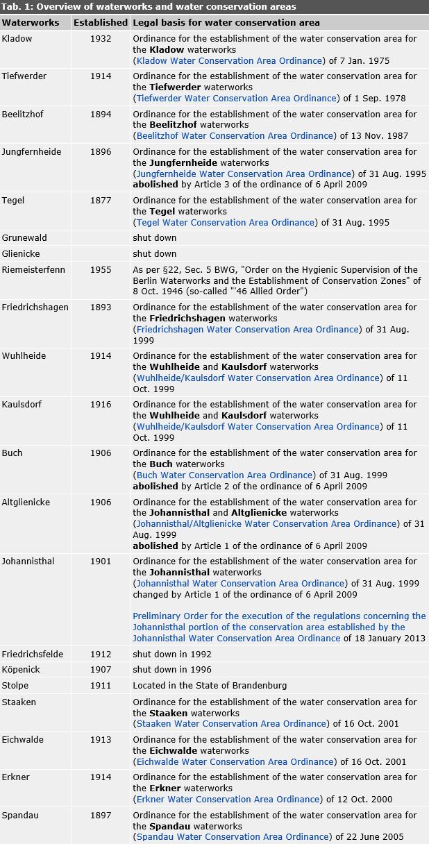
For the water conservation district of the Johannisthal waterworks exists a "Preliminary Order for the execution of the regulations concerning the Johannisthal portion of the conservation area established by the Johannisthal Water Conservation Area Ordinance" of 18 January 2013 until the commencement of a new water conservation area ordinance. The preliminary order was published in the Official Journal of Berlin of 22 February 2013. Different regulations may apply to locations in the area of the Johannisthal Conservation Area after this date.

The Staaken, Eichwalde and Erkner waterworks are located in the State of Brandenburg, and are not operated by the BWB. Corresponding to the water catchment areas for groundwater withdrawal for drinking water purposes, the water conservation zones here cross the border. The Berlin ordinances for these waterworks serve for the protection of those parts of the cross-border water conservation zones located on Berlin territory.

The wording of the respective ordinance (in German) can be found under www.berlin.de/sen/umwelt/wasser/wasserrecht/

The Riemeisterfenn waterworks is the only one that still falls under the "Order on the Hygienic Supervision of the Berlin Waterworks and the Establishment of Conservation Zones" of 8 Oct. 1946.

A fixed, limited amount of drinking water for the supply of Berlin is also discharged at the Stolpe waterworks, located in the State of Brandenburg and operated by the BWB. This involves an authorised exception to the stipulation of § 37a BWG, according to which the water required for the public water supply of Berlin is to be obtained within the territory of Berlin.

Criteria for the Delimitation of Water Conservation Areas

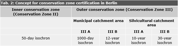
According to the stipulations of §51 WHG and §22 BWG, drinking water conservation areas are to be subdivided into zones with different protective regulations. The goal of the structure by conservation zones is to take the principle of proportionality into account. Since the danger for the groundwater used decreases with the distance of the source of danger from the wells, the zones are subjected to increasingly weaker restrictions the further they are from the wells.

Under the older regulations, applicable in Beelitzhof, Kladow and Tiefwerder, no differentiation was made within the remotest conservation zone, Zone III. In the water conservation area ordinances issued since 1995, Conservation Zone III has been subdivided into III A and III B.

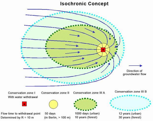
The basis for the measurement and certification of drinking water conservation zones is the Technical Regulations of the German Technical and Scientific Association for Gas and Water (DVGW). The basis for the measurement of the breakdown into conservation zones in modern water conservation area ordinances is the isochronic concept. Isochrons are lines showing equal flow times of the groundwater. These are ascertained with the aid of hydrogeologic investigations, and "projected" onto the terrain surface, taking the hydrogeological, hydrological and geological conditions into account. The conservation area boundaries of the conservation zones II, III A and III B are established, with additional consideration for local conditions within a technically acceptable framework (e.g. housing, infrastructure). To make as clear as possible a determination, the actual delimitation is carried out along existing lot boundaries, pathways, streets or other markings.

Flow times to the point of withdrawal for the modern certification of conservation zone boundaries in Berlin:

  • Conservation Zone II: 50 days
  • Conservation Zone III A: 500 days to 10 years
  • Conservation Zone III B: 2500 days to 30 years

Due to the great expanse of the catchment areas of the waterworks considered – they extend far into Brandenburg – additional considerations were required in Berlin in order to resolve the conflict between a generally stricter groundwater conservation system on the one hand and an urban development with economic interests on the other. Here, it was possible to use the concept developed by Lühr & Schulz-Terfloth in 1992, so as to distinguish between inner-city catchment areas with a dense population, and rural catchment areas with a silvicultural character. The main criterion is that despite all safety precautions, an accident or disruptive incident involving water-endangering pollutants cannot be excluded, and that the conservation zones must therefore be extended at least far enough to provide sufficient time allow the implementation of effective defensive measures for the protection of discharge wells. Thereafter, different flow times were used as the basis for delimiting conservation zones (Schulz-Terfloth 1998) in the urban-type areas than in those with a silvicultural character (see Table 2 and Fig. 3).

Tab. 2: Concept for conservation zone certification in Berlin

Tab. 2: Concept for conservation zone certification in Berlin

Fig. 3: Structure of the water conservation zones under the isochronic concept

Fig. 3: Structure of the water conservation zones under the isochronic concept

Zone I is defined by a radius of at least 10 m around the wells.

The conservation zones stipulated by the older water conservation area ordinances were established with consideration for then-current hydrogeological investigations and assessments of the subsoil, according to surface distances.
The conservation zones according to § 4 of the Order of 8 October 1946 were defined according to aboveground radial distances from the wells (100 m for the inner conservation zone, 500 m for the outer conservation zone). Here too certain use restrictions apply.