Efficient water planning and water resource management based on the principles of sustainability requires knowledge of surface runoff and percolation, and of new groundwater formation that is as precise as possible. Budgeting the components of water balance is of particular importance, especially in the Berlin area, which has only limited water resources, compared with other urban centres. There is also a clear imbalance between these resources and the number of inhabitants, their drinking and non-potable water needs and the associated wastewater produced.
Moreover:
- It is important for the prevention of water pollution to be able to assess the amount of surface water flowing into the local bodies of water, since the precipitation water carries a considerable pollutant load into those bodies of water with it;
- It is important for the protection of groundwater to have knowledge of the percolation capacity of the soils, since the transportation of substances from contaminated soils occurs largely via percolation water;
- It is important for conservation and landscape management to assess the water availability for vegetation from new groundwater formation and capillary water rising from the groundwater surface.
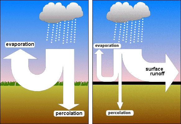
The water supplied by precipitation to an area is broken down into the various components of the water balance, depending on climatological conditions and other local characteristics. These components are evaporation, surface runoff, sub-surface runoff (percolation or new groundwater formation) and water-inventory change. The parameter which must initially be ascertained is total runoff, the sum of surface and sub-surface runoff.
According to the general water-balance equation, total runoff equals the difference between precipitation and real evaporation. In this calculation, evaporation is the decisive quantum which, under natural conditions, is determined largely by vegetation, climatic conditions and soil conditions.
In urban areas however, real evaporation is considerably different from that of the surrounding countryside. Buildings and impervious areas in cities cause evaporation to be considerably lower than in areas covered with vegetation. While the plants continually perspire through their foliage, the only water to evaporate from the surfaces of buildings and impervious areas after rainfall is that small amount which has remained on their surfaces. Thus, total runoff is considerably higher in urban areas than in vegetation-rich areas.
In Berlin, for several years, roof planting has been increasingly used as an element of rainwater management. It reduces the runoff of rainwater and creates evaporation areas. In order to incorporate this effect in the water balance maps of the Environmental Atlas, since the 2019 issue the, green roofs of Berlin (cf. 06.11 Green Roofs) have been included in the calculations.