Actual Use of Built-up Areas / Inventory of Green and Open Spaces 2021

Methodology

Mapping Rules

For a detailed description of the mapping rules, please refer to Part II of the Final Documentation of 2020 (SenSW 2021). This section provides an overview of the most important mapping rules.

  • Minimum size: ISU block segment areas may only be formed if they comply with the minimum size of 1 ha and the minimum width of 20 m. If a block contains fragments below the 1 ha limit with different uses, the dominance principle applies, i.e. the use of the larger fragment is mapped. In exceptional cases, e.g. when mapping soil associations that are particularly worthy of protection or when demarcating railway areas, the minimum size may be deviated from.
  • New block (segment) keys: when a new additional block segment area is defined, it receives the next higher block segment key that has not yet been assigned. The now reduced block segment area with the ‘old’ use retains the ‘old’ key.
  • Merging block segment areas: when block (segment) areas are merged, the resulting area retains one of the ‘old’ block segment area keys, usually that of the larger area or the key of the area the for which the use attributes are decisive.
  • Differences between ISU and RBS (regional reference system) blocks:
    • Where RBS block boundaries differed greatly from those of the ISU, the AfS was consulted and the RBS block in question was corrected.
    • Greenery along roads: green spaces along roads are not part of the road area but should be included in the adjacent ISU block.
    • Road area boundaries: all areas of the ALKIS category ‘Classification according to road law’ and the LGV (Berlin land assets) category ‘Civil engineering of the borough’ are considered areas outside the block according to AfS rules but are part of the blocks in the ISU map. This is the case, for example, for larger car parks adjacent to road areas.
    • Differentiated land use within road areas, such as medians and traffic islands, is not reflected in the RBS geometry.
    • Footpaths: park footpaths are generally part of the park and are not classified as road areas. Larger forest trails that have been delineated as road areas should remain so, if they do not run along the boundary of an RBS block. The delineation of footpaths should be as differentiated as possible based on aerial photographs (without foliage) and the geodata set of the road survey.
  • New use not yet visible in the aerial photograph: for new blocks, only existing types of land use or construction sites that are visible in the aerial photograph should be recorded. Planned but not yet existing structures are not mapped.
  • Bridges: railway lines are shown without interruption. For motorway bridges, the land use under the bridge is mapped.
  • Maintaining the boundaries of soil associations: maintaining the boundaries of soil associations in populated areas is not a priority. Here, it is more important to precisely delineate the land use visible on the aerial photograph.

Methodology of the Documentation Process

In the course of the update, the existing data of the block and block segment areas was revised both in terms of geometry and factual data, i.e. the categories of building use (WOZ), the categories of green and open space use (GRZ), and the area types (TYP in German, TYPE in the following). In order to document these changes transparently and comprehensively, the same method was used as for recording the changes in the 2020 mapping with slight modifications (see Final Documentation of 2020, Chapter 10). The documentation process is based on the collection of a set of attributes for each block (segment) area. The attributes are then added as numerical fields or text fields to the geodata record of the ISU block (segment) area map.

The process is carried out for all areas that have been changed as well as those that have been reviewed but not changed. This allows for a transparent history of the review and decision-making process, also for future updates. The documentation process and the attributes used in the current update are presented below. Compared to the 2020 update, the attributes have been slightly modified and the numerical codes reassigned (cf. Final Documentation of 2020, Chapter 10). Important changes are listed below.

The attribute [anpassgeo21] now distinguishes between 4 different cases represented by the numerical codes 1-4: neither the geometry nor the block (segment) key was changed, both the geometry and the block (segment) key were changed, only the geometry was changed or only the block (segment) key was changed.

Instead of the previous 3 cases, the attribute [anpassnutz21] now distinguishes between 2 cases. The numerical code 3 is omitted. It was assigned for the case that a smaller block segment area was integrated into a larger block segment area. Now, the old land use attributes of the small block segment area are not documented in this case and the code 1 (= unchanged land use) is assigned.

The general rules for documenting changes were retained. The data format description (only available in German) presents all attributes that were created in the geodatabase for documenting changes, which are attached to each ISU block (segment) area. The documentation attributes of the last update also remain part of the geodata set and provide an insight into the change history.

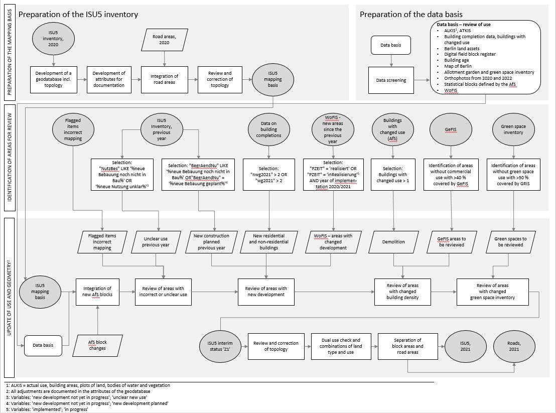
Fig. 1: Data processing diagram for the ISU5 update, as of December 31, 2021

Methodology of Data Processing

The current update is based on the ISU5 block map (1 : 5,000, spatial reference: Environmental Atlas, 2020) as of December 31, 2020.

To verify the actual use visible in the aerial photographs, data on a selection of specialist topics was used. Prior to processing, the datasets were checked for validity and usability. Based on these datasets, areas to be reviewed in terms of land use were derived through selections and intersections with the ISU5 dataset.

The steps involved in compiling the areas for review are presented below:

  • New development:
    • Selection of all block (segment) areas from the building completion data for which a building completion (non-residential and residential) of more than 2 buildings was recorded in 2021 (attributes “nwg2021” > 2 and “wg2021” > 2).
    • Selection of all block (segment) areas that are covered by more than 20 % by the areas from the Housing Construction Space Information System with the status “implemented” or “in progress” and the year of implementation of “2021”, “2022” or “n/a”.
  • Building with changed use: selection of all areas containing buildings with changed use in 2021.
  • Inventory of Green Spaces (GRIS): intersection of the “Inventory of Green Spaces, 2021” with the ISU block (segment) areas, identification of all areas that are covered by GRIS areas by more than 50%, but do not have a green and open space use (GRZ) of 100, 110, 130, 140, 150 or 190.
  • Commercial areas (GeFIS): intersection of the areas from the “Commercial Area Information System” (GeFIS) with the ISU block (segment) areas, identification of all areas that are covered by GeFIS areas by more than 40 %, but do not have a building use (WOZ) of 21 or 40.
  • Flagged items: selection of all block (segment) areas for which “unclear new use” or “new development not yet in progress” or “new development planned” was noted in the documentation attributes during the 2020 update, and selection of all other flagged items collected since the previous update.

The geometry of the ISU5 map is based on the statistical blocks of the RBS (regional reference system) defined by the Statistical Office for Berlin-Brandenburg (AfS). The geometry of both the main and the meta blocks of the ISU5 map is largely consistent with the RBS blocks. The boundaries differ slightly at many points, which often serves to delineate the use more precisely. The 6-digit RBS block key is incorporated into that of the 16-digit block and block segment area key of the ISU5 at positions 4-9. The blocks of the RBS are continually updated by the AfS. Especially in areas with new or changed development, the existing RBS blocks are adjusted or new blocks are defined.

All blocks that were newly defined or changed by the AfS between June 1, 2021 and January 3, 2022 were included in the ISU5 block map as part of the 2021 update. For this purpose, the geometries of the new blocks were delineated, the new main block key was adopted and the land use attributes were reviewed and modified if necessary. The AfS often defines new blocks in areas with changed land use.

All block (segment) areas with at least one reason for review were checked on the aerial photograph for a change/ correction of land use. If there was a need for correction, the geometry and/ or key and/ or use attributes were updated and the change was recorded in the documentation attributes. In addition to the orthophotos, the specialised datasets shown in Fig.1 were used to verify the actual use.

Road sections were also reviewed as part of the current update and modified where necessary. When a new road section was created, it was assigned a new unique road key and the road section was placed in one of the two categories “road of the primary road network” or “other road” using the “primary road network” data set. Any changes made for the road sections were also recorded in the documentation attributes.

Once the update was complete, the land use attributes were checked with regard to the permissible combinations (cf. Final Documentation of 2020, Chapter 8.1), followed by another review of the topology.

After reviewing the identified areas, the ISU block (segment) area boundaries were adjusted to the ALKIS borough and state boundaries in an independent process. As a result, the two sets of boundaries are now exactly the same.