Water Conservation Districts 2006

Introduction

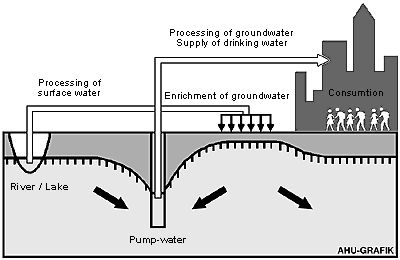
The drinking water needs of Berlin are met primarily by groundwater. The drinking water supply is managed by the Berlin Public Water Companies. Water supplies are partially obtained as bank filtered water: surface waters filter through the soil and are withdrawn by extraction wells near the banks). Some surface water is diverted into groundwater recharge plants to percolate into groundwater, which will then be withdrawn for use.

Fig. 1: Principles of Groundwater Production

Fig. 1: Principles of Groundwater Production

There are also a number of smaller production plants, the private sector water supply plants, which withdraw groundwater for private sector purposes, mostly industrial, or withdraw groundwater for public facilities.

Construction increased considerably after the unification of Berlin in 1990. Groundwater retention is practiced during construction when groundwater is withdrawn. This occurs according to construction activity at various locations and in variable amounts. Especially deep and/or large construction projects use the trough construction method which spares groundwater. This method requires the withdrawal of only small amounts of water.

However, in May 2005, the phreatic surface, which has been lowered in Berlin by drinking-water discharge over the past hundred years, was, all in all, compared to 1989 at a relatively high level, as it had been during the previous eight years. The reason for this is the reduced raw-water discharge by the Berlin Water Utility. Five smaller Berlin waterworks (Altglienicke, Friedrichsfelde, Köpenick, Riemeisterfenn und Buch) discontinued their production altogether during the period between 1991 and 1997 were closed during the period between 1991 and 1997: Altglienicke, Friedrichsfelde, Köpenick, Riemeisterfenn and Buch. In addition, drinking water production at the two waterworks Johannisthal and Jungfernheide was discontinued temporarily since September 2001; at the latter, the same was true for artificial groundwater recharging. In the context of groundwater management by the Senate Department for Urban Development, groundwater is, however still discharged at both locations, so as not to endanger current local waste disposal and construction measures.

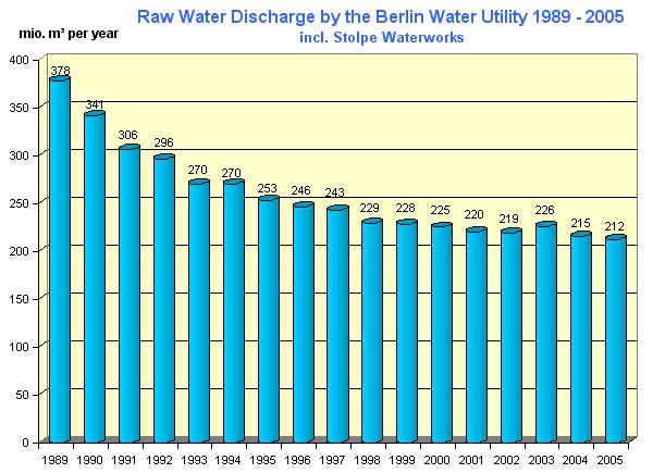
The overall discharge of the waterworks for drinking water purposes has dropped by over 40 % in Berlin during the past 16 years (Fig. 2). In 1989, 378 million m3 were discharged, as opposed to 219 million m3 in 2002. In 2003 the discharge increased lightly to 226 million m3 because of the dry summer, to fall again in 2005 to 212 million m3.

Fig 2: Drop in Raw-Water Discharge by the Berlin Water Utility during the past 16 Years

Fig 2: Drop in Raw-Water Discharge by the Berlin Water Utility during the past 16 Years

Legal Principles

As a framework for regional legislation, the Federal legislature have provided the "Gesetz zur Ordnung des Wasserhaushalts (Wasserhaushaltsgesetz – WHG) – water supply regulations. §19 The WHG forms a basis for the regional authorization of water conservation areas.

§ 19 Water Conservation Areas

(1) as far as circumstances permit, Water Conservation Areas can be established,
  1. to protect the present and future public water supply from disadvantageous effects or
  2. to enrich the groundwater or
  3. to prevent groundwater damage resulting from precipitation and the loss of nutrients or the absorbtion of impurities from pesticides or fertilizers.
(2) In the Water Conservation Areas
  1. damaging actions can be prohibited or severely restricted and
  2. special measures can be taken to prevent damage resulting from the actions or rights of property owners and users. The obversation and protection of soil and groundwater is an integral part of these measures.

Other regulations of the legislature have only an indirect effect on the procedures. Of note here are the "Gesetz über Abgaben für das Einleiten von Abwässer in Gewässer (Abwasserabgabengesetz – AbwAG)" and the "Verordnung über Trinkwasser und über Wasser für Lebensmittelbetriebe (Trinkwasserverordnung – TrinkWV).

Together with the Federal legislature, the Berlin Water Rights policy which summarises the laws, legal ordinances and administration regulations, forms the basis for the establishment of water conservation areas (WSG).

In conjunction with the partial privatisation of the Berlin water companies (BWB) in the year 2000, the new (Berliner Wassergesetz -BWG) § 37 was established, and proposes that all waters needed for Berlin’s public water supply should be taken from the Berlin region.

To assist in the implementation of the WSG proposals for

§ 22 Wasserschutzgebiete (Water Conservation Areas)

(1) Water conservation areas are fixed by regulation of the senate. The protection regulations are to be marked in the ordinance. Zones with different protection regulations can be fixed. (…)

(2) In the establishment of water conservation areas, the local authorities and local public bodies should be involved.

(3) A hearing procedure is a necessary part in the establishment of a water conservation area. Decisions and plans are to be publicized in the official Berlin "Amtsblatt". The following must be observed,
  1. Plans, (drawings, proofs and descriptions) showing the full scope of the water conservation zones and the proposed protection regulations should be available for one month and
  2. Objections to the proposed measures can be raised up to two weeks (at the latest) from the end of the publication period… (…)

In addition, the laws regulate the division of standing waters and rights pertaining to property ownership, use of water and official responsibility. Furthermore, the maintenance and building of embankments and constructions at or in standing waters.
Water Conservation Areas

The Berlin water law distinguishes two legal qualitative definitions of protected areas:

For water conservation areas situated in west parts of the city §22 Abs. 5 the "Anordnung über die hygienische Überwachung der Berliner Wasserwerke und die Bildung von Schutzzonen" vom 08.10.1946 (ie. 1946 Allied Ordinances) is relevant.

This ordinance determine still only one following protected area:

  • Waterwork Riemeisterfenn

From §22 Abs.1 the BWG were remitted the following protection ordinances by the Senate Department for City Development :

  • Ordinance for the water conservation area Kladow Waterworks
    (Water Conservation Area Ordinance Kladow) from 07.01.1975
  • Ordinance for the water conservation area Tiefwerder Waterworks
    (Water Conservation Area Ordinance Tiefwerder) from 01.09.1978
  • Ordinance for the water conservation area Beelitzhof Waterworks
    (Water Conservation Area Ordinance Beelitzhof) from 13.11.1987
  • Ordinance for the water conservation area Jungfernheide Waterworks
    (Water Conservation Area Ordinance Jungfernheide) from 31.08.1995
  • Ordinance for the water conservation area Tegel Waterworks
    (Water Conservation Area Ordinance Tegel) from 31.08.1995
  • Ordinance for the water conservation area Buch Waterworks
    (Water Conservation Area Ordinance Buch) from 31.08.1999
  • Ordinance for the water conservation area Friedrichshagen Waterworks
    (Water Conservation Area Ordinance Friedrichshagen) from 31.08.1995
  • Ordinance for the water conservation area Johannisthal and Altglienicke Waterworks
    (Water Conservation Area Ordinance Johannisthal / Altglienicke) from 31.08.1999
  • Ordinance for the water conservation area Wasserwerke Wuhlheide and Kaulsdorf Waterworks
    (Water Conservation Area Ordinance Wuhlheide / Kaulsdorf) from 11.10.1999
  • Ordinance for the water conservation area Erkner Waterworks
    (Water Conservation Area Ordinance Erkner) from 12.10.2000
  • Ordinance for the water conservation area Staaken Waterworks
    (Water Conservation Area Ordinance Staaken) from 16.10.2001
  • Ordinance for the water conservation area Eichwalde Waterworks
    (Water Conservation Area Ordinance Eichwalde) from 16.10.2001
  • Ordinance for the water conservation area Spandau Waterworks
    (Water Conservation Area Ordinance Spandau) from 22.06.2005

You will find the text of the ordinances under Wasserrecht (only in German).

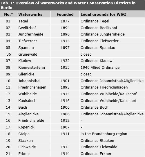
Tab. 1: Overview of waterworks and Water Conservation Districts in Berlin

Tab. 1: Overview of waterworks and Water Conservation Districts in Berlin

h6. No. of the water conservation zone as documented in the SenStadt report VIII E

Criteria for the scope of Water Conservation Districts

Conservation zones are set on observing the relationship between protection regulations and the distance from the water source. Taking the increased interest in conservation and protection of groundwater into account, drinking water wells are covered by zones with stronger protection regulations. For the individual WSGs, different criteria for the demarcation was assessed on the basis of the heterogeneous legal status (hydrology, geology, local conditions, settlement).

1946 Allied Ordinance

Water conservation zones in areas regulated by Section 4 of the Magistral Ordinances of 8 October 1946 were determined use limitations. This ordinance proceeded from an order of the Allied Commandant of Berlin, valid for all Berlin. The conservation zones are divided into a narrow conservation zone (zone II) with a radius of 100 m around extraction wells, and into a wider conservation zone (zone III) with a radius of 500 m. The captation area (zone I) is defined by the water conservation area ordinance with a radius of 10 m around the wells. In case of well galleries the areas will be connected.

Water conservation area ordinance

The regulations enacted until further notice are divided into two groups.

Under the old Regulations the differentiation of the wider protection zone III was not determined. (Beelitzhof, Kladow, Tiefwerder (issued between 1975 and 1987)). After 1988, protection zone III was re-defined into IIIa and IIIb.

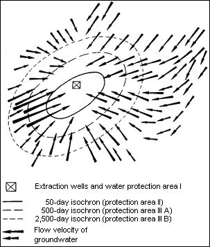
Under the new Regulations, the Isochronic concept (comp. fig. 3) is the measuring principle used.

The isochronic concept determines the size of water conservation districts and their geometric forms of zone II, IIIa and IIIb in hydraulic terms: from the flow time of water to the removal site. To get a clear fixing of the areas the real scope follows existing site or land borders or clear visable terrain marks.

Flow times at the removal sites for determining the conservation district borders:

  • conservation zone II: 50 days
  • conservation zone IIIa: 500 days
  • conservation zone IIIb: 2.500-3.500 days

The determination of the isochrons, and thus the conservation district borders, proceed from hydrogeologic examinations of a given area. A regional groundwater flow model is developed for this area. The goal of the concept is to have sufficient time for damage control should soil (and/or groundwater) be contaminated.

Fig. 3: Example for Definition of a Water Protection Area According to the Isochronic Concept The flow velocity of groundwater is indicated by the length of the arrows. The longer the arrow, the higher the flow velocity.

Fig. 3: Example for Definition of a Water Protection Area According to the Isochronic Concept The flow velocity of groundwater is indicated by the length of the arrows. The longer the arrow, the higher the flow velocity.

Use limitations within conservation districts were supplemented and extended in the course of revising the Water Conservation District Regulations according to the isochronic concept.