Management of Rain and Waste Water 2022

Map Description

02.09.1 Type of Drainage

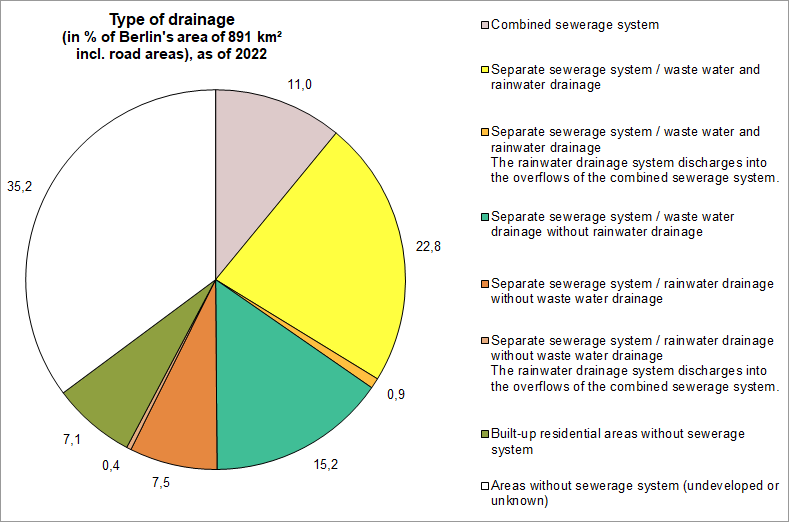
About 58 % of Berlin’s total area is connected to the drainage system. Of that area, 81 % is drained by the separate sewerage system, the remaining share (19 %) by the combined sewerage system. This reperesents 11 % of the total urban area. Figure 1 presents the area shares by drainage type. The part of the urban area with separate drainage is divided into the following systems: the separate sewerage system with waste water and rainwater drainage accounts for the largest share (22.8 % of the urban area), followed by the separate sewerage system with waste water drainage but without rainwater drainage (e.g. in areas where rainwater percolates completely) with 15.2 %. A share of 7.5 % represents areas with rainwater drainage but without waste water drainage. These are almost always road areas or isolated block and block segment areas, mainly traffic areas. Areas where rainwater drains into the overflows of the combined sewerage system constitute a unique case of the separate sewerage system. Thus, 0.9 % of Berlin’s area is connected to the waste water and rainwater drainage system and discharges water into the overflows of the combined sewerage system. In addition, 0.4 % of the area only has rainwater drainage and also discharges water into the overflows of the combined sewerage system.

Built-up residential areas without drainage include those block and block segment areas that are not connected to the drainage system and contain areas that are both built-up and impervious. These block and block segment areas are particularly prominent in the current update, accounting for 7.1 % of the total area. This is due to the new method in which the built-up area was evaluated based on the degree of imperviousness (cf. Environmental Atlas Map 01.02, SenSBW 2021). In previous editions, imperviousness was not taken into account, instead certain types of use were associated with being undeveloped and not connected to the drainage system. These areas are mainly drained via septic tanks. Transport companies then take the waste water to sewage treatment plants. Almost half of the areas are allotment gardens and weekend cottage areas, i.e. areas that have not been evaluated thus far. Similarly, a considerable proportion of the areas are block and block segment areas with very few structures, such as parks, cemeteries or forest areas with isolated buildings.

Approximately 35% of Berlin’s total area is either not connected to the sewerage network or the Berlin Waterworks have not provided information on the areas (private drainage).

Fig. 1: Type of drainage in % including road areas (891 km²), as of 2022

Fig. 1: Type of drainage in % including road areas (891 km²), as of 2022

In recent years, increased construction activity and the associated increase in both impervious areas and the efforts of the Berlin Waterworks to expand the sewerage network into previously unconnected residential areas have resulted in new areas being connected to the drainage system. At the same time, the decoupling of already connected areas became a goal and has already been implemented in many cases. This is mainly done in areas with combined systems in order to reduce the overflow of combined sewage into water bodies.

Local rainwater management in which the rainwater is not discharged but percolates or is used directly on site, is not yet included in the current map “Type of Drainage”.

A look at how the different systems are distributed across the urban area reveals the following key areas.

In the inner-city areas of Wedding, Tiergarten, Mitte, Prenzlauer Berg, Friedrichshain, Kreuzberg Schöneberg, parts of Neukölln and Wilmersdorf, Westend and in the old town of Spandau, waste water and rainwater is drained together via the combined sewerage system.

The boroughs of Reinickendorf, Lichtenberg, Marzahn-Hellersdorf, Treptow-Köpenick, Steglitz-Zehlendorf and the outer areas of the boroughs of Pankow, Neukölln, Tempelhof-Schöneberg, Charlottenburg-Wilmersdorf and the majority of Spandau are connected to the separate sewerage system.

In Berlin, the most common type of separate sewerage system is that of rainwater drainage combined with waste water drainage. Areas with this type of system are mainly found in the outer areas. This is the case for the boroughs of Spandau, Reinickendorf, Pankow, Lichtenberg, Marzahn-Hellersdorf, Treptow-Köpenick, Neukölln, Tempelhof-Schöneberg and Steglitz-Zehlendorf, as well as some south-western parts of Wilmersdorf-Charlottenburg, a small area in the north-eastern part of Mitte, and the Stralau peninsula in the south-eastern part of Friedrichshain.

Rainwater drains which connect to the rainwater overflows of the combined sewerage system were built in some parts of Wilmersdorf, Weißensee and Spandau, as well as areas of Charlottenburg along Schloßstraß in order to reduce the load on the combined sewerage system. In these areas, waste water continues flow into the combined drains. There are also areas without waste water drainage in these regions. Their rainwater drains also connect to the rainwater overflows of the combined sewerage system. These are mostly road areas.

In areas with waste water drainage but without rainwater drainage, rainwater may percolate in a controlled or uncontrolled manner. These areas are distributed across all regions with separate sewerage systems and are often found on the outskirts of the city.

The development of Category I old settlement areas (main areas to be connected to a sewerage system) has been completed (House of Representatives of Berlin 2009). The development of the Wartenberg settlement area was also completed in 2018. There are still further old settlement areas without sewerage systems. It was decided that the sewage development of five of these areas (Biesenhorst, Buchholz Nord I, Schönholz, Karow Süd, Karow Ost) would be completed by 2030. The strategy for the remaining eight old settlement areas (Schmöckwitz-Werder, Schmöckwitz Schwarzer Weg, Neu-Venedig, Rahnsdorf-Süd, Siedlung Schönhorst, Siedlung Spreewiesen, Gatow Siedlung Habichtswald, Blankenfelde Altsiedlung) will be decided at a later stage.

What is more, there is still a variety of individual roads, that has not yet been connected to the central waste water treatment system either (gap closure areas). These will be developed successively.

02.09.2 Catchment Areas of Rainwater Drainage

Depending on the main receiving water body, the catchment areas of rainwater drainage systems are part of the catchment areas of the Spree and Dahme rivers in the eastern and southeastern areas of Berlin, of the Havel river in the northern, northwestern and southwestern parts of Berlin, and of the catchment area of the Teltowkanal in the south of the city.

Lakes, park lakes, ponds and other drainage basins are spread over the entire area of the city.

Since the combined system prevails within the area of the inner S-Bahn Circle Line, and rainwater only rarely enters the water system, it was not assigned to any rainwater drainage catchment area. Exceptions are parts of Tempelhof and Wilmersdorf, north of the urban motorway, which drain into the canals south of the Spree (the Neuköllner Schifffahrtskanal and the Landwehrkanal) and the Alt-Treptow area, which drains into the Spree. Other exceptions include smaller areas that are located in a combined system area but are connected to a separate system locally, such as the Nikolaiviertel and individual roads that have separate drainage.

Tab. 2: Rainwater discharge into the drainage system - catchment areas and impervious area connected to the system, as of 2022

Table 2 shows the total area of the catchments for each water body section. Based on the most recent mapping of the degree of imperviousness of the block and block segment areas from 2021 (cf. Environmental Atlas 01.02, SenSBW2021), it is also possible to identify impervious areas within the catchment areas. As already described, however, not all impervious areas within blocks and block segment areas with rainwater drainage are completely connected to the rainwater drainage system. Table 1 of the accompanying text to the Environmental Map 02.13.1 “Surface Runoff from Precipitation” (SenStadtWohn 2017) was used to establish the impervious area for each block and block segment area that is actually connected. This table contains consolidated actual connection rates for each Urban Structure Type (Area Type), divided into buildings, roads and other impervious areas. The connection rate in the area types of the outer areas therefore indicates that, in some cases, only 30 % of the impervious areas are connected. For road areas, it was assumed that 100 % of the impervious parts are connected. The actual connection rate may vary considerably locally, but the figures nevertheless provide some insight into the characteristic properties of the catchment areas.

Table 5 of the accompanying text to Map 02.13.1 “Surface Runoff from Precipitation 2017” shows the discharge volumes into Berlin’s water bodies grouped together by section. Part of the surface runoff in the area of the combined system enters the water bodies directly via the emergency outlets of the pumping stations and the rainwater overflows of the sewerage network during heavy rainfall. The remaining part is transported to the sewage treatment plants. After appropriate waste water treatment, it is then discharged into the water bodies together with the treated waste water.

The Teltowkanal (including the Rudower Arm) has the largest catchment area of the rainwater drainage system with more than 81 km². It is followed by the Wuhle with a catchment area of 20 km² and the Panke (from the Verteilerbauwerk) with approx. 17 km². Most of the rainwater from the 98 km² combined sewerage system flows into the sewage treatment plants (cf. Environmental Atlas “Surface Runoff from Precipitation” 02.13.1, SenStadtWohn 2017).