Green Volume 2010

Map Description

The map illustrates the green volume for blocks, block segments and road areas. As expected, the highest green volume numbers were recorded for Berlin’s forest areas. Varying green volume numbers were also recorded within residential areas, however, which are described in more detail below.

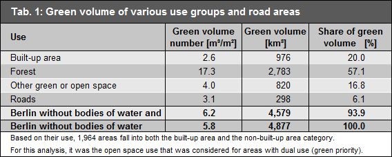
In total, Berlin has a green volume of 4.877 km³, excluding bodies of water. This corresponds to an average green volume number of 5.8 m³/m². As expected, more than half of the green volume stems from forest areas (2.783 km³, 17.3 m³/m²). The built-up blocks and block segments house the least vegetation per area (2.6 m³/m²) as do the roads (3.1 m³/m²) (Table 1, cf. Environmental Atlas Maps 06.01 and 06.02).

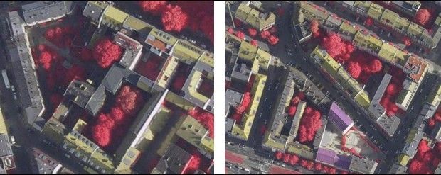
Regarding the green volume of road areas, it should be noted that it is mainly roadside trees and vegetation, e.g. tree crowns, protruding from blocks and block segments that influence green volume calculations. Due to the cylinder graph used (cf. Figure 1), the green volume is often overestimated here, compared to other areas.

Tab. 1: Green volume of various use groups and road areas

Tab. 1: Green volume of various use groups and road areas

On closer inspection of the area type level, and especially the residential development, striking differences within the built-up area become evident. The green volume numbers of the total areas corresponding to residential blocks and block segments vary between 0.8 m³/m² for the area type “Core area” and up to 4.7 m³/m² for “Villas and town villas with park-like gardens” (cf. Table 2 and Figure 5).

Comparing the green volume numbers for non-built-up parts of residential blocks and block segments, however, the numbers for densely built-up area types also increase in some cases, which applies particularly to the following area types:

  • “Dense block-edge development, closed rear courtyard, 5 – 6 storey”,
  • “Closed block development, rear courtyard (1870s-1918), 5-storey”,
  • “Closed and semi-open block development, decorative and garden courtyard (1870s-1918), 4-storey” and
  • “Block-edge development with large quadrangles (1920s-1940s), 2 – 5 storey”.

In relation to the entire block and block segment, these area types display a low green volume number. However, considering the non-built-up parts only, the green volume number rises sharply. This is mainly due to the existing old tree stocks, which occupy a large volume on a relatively small area (Figure 4).

Fig. 4: “Closed block development, rear courtyard (1870s-1918), 5-storey” incl. old tree stocks (left: example from Gipsstraße to Sophienstraße; right: example north and south of Zehdenicker Straße, Background: digital and coloured ortho-photos 2010 (DOP20CIR, pseudocolouring)

Fig. 4: “Closed block development, rear courtyard (1870s-1918), 5-storey” incl. old tree stocks (left: example from Gipsstraße to Sophienstraße; right: example north and south of Zehdenicker Straße, Background: digital and coloured ortho-photos 2010 (DOP20CIR, pseudocolouring)

For area types with a more balanced ratio between built-up and non-built-up parts, there is little difference between the green volume numbers of the total block area and the non-built-up part. Furthermore, the green volume numbers are generally lower here than in densely built-up areas (Table 2, Figure 5). This is also related to greenery, which is often characterized by a high proportion of low-growing vegetation or lawns (“green fringes”). The following residential area types of private and rental housing construction illustrate these conditions:

  • “Rental-flat buildings of the 1990s and later”,
  • “Row houses and duplex with yards”,
  • “Detached single-family homes with yards”.

Forest tree estates constitute a special case within the overall green volume picture. These are estates that were built on Berlin’s forest edges. Their gardens and open spaces are characterized by stocks of old pine, oak and birch trees. The Berlin Landscape Programme identifies areas of forest tree estates along the Grunewald Forest, the Spandau Forest, in Gatow, in the Köpenick Forest, in Hermsdorf, Frohnau and Waidmannslust (cf. SenStadtUm 2016b). In contrast to residential areas built on former farmland areas (e.g. the ground moraines of the Teltow and Barnim plateaus consisting of bolder clay and marl), the green volumes differ significantly.

Tab. 2: Green volume number of area types

Tab. 2: Green volume number of area types

Fig. 5: Green volume number of residential area types

Fig. 5: Green volume number of residential area types

Figure 6 illustrates the distribution of uses at an aggregate level. The range of values for heterogeneous residential area types is discussed above. In this representation, the high values for non-built-up parts under “Cemetery” and “Public and special use” stand out in particular. Structurally, the cemeteries differ mainly in their tree population. Especially the forest and old park cemeteries influence the green volume number positively.

The “Public and special use” category displays the highest green volume number for built-up use excluding cemeteries. This is due to a large number of areas with a high proportion of greenery and trees, e.g. the Olympiapark and hospital locations with old tree stocks, which fall into this use type.

The relatively low green volume number of 1.5 m³/m² for allotments may be explained with the planting and management regulations, which prohibit the planting of large deciduous trees as well as decorative trees and shrubs. Parks and green spaces are at least partially characterized by trees and shrubs, resulting in the second highest green volume numbers, following those of forest areas.

Fig. 6: Green volume number of various uses and roads

Fig. 6: Green volume number of various uses and roads