The prerequisite for a water-management planning process and a management system for water resources oriented toward the principles of sustainability is that the knowledge of surface runoff and seepage, and of new groundwater formation, be as precise as possible. For this, an accounting of the components of the water balance is of special importance, especially in the Berlin area, which has only limited water resources, compared with other urban areas, and where the number of its inhabitants and their drinking and industrial water needs, and the associated sewage output, result in a structural water-management deficit.
Moreover:
- It is important for the prevention of water pollution to be able to assess the amount of surface water flowing into the local bodies of water, since the precipitation water carries a considerable pollutant load with it into those bodies of water;
- It is important for the protection of groundwater to have knowledge of the seepage capacity of the soils, since the transportation of substances from contaminated soils occurs largely via seepage water,
- It is important for conservation and landscape management to assess the water availability for vegetation from new groundwater formation and capillary water rise from the groundwater table.
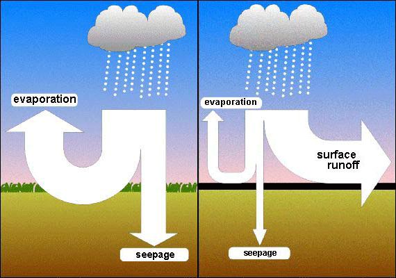
The water supplied by precipitation to an area is broken down into the various components of the water balance, depending on climatological conditions and other local characteristics. These components are evaporation, surface runoff, sub-surface runoff (percolation or new groundwater formation) and water-inventory change. The parameter which must initially be ascertained is total runoff, the sum of surface and sub-surface runoff.
According to the general water-balance equation, total runoff equals the difference between precipitation and real evaporation. In this calculation, evaporation is the decisive quantum which, under natural conditions, is determined largely by vegetation, climatic conditions and soil conditions.
In urban areas however, real evaporation is considerably different from that of the surrounding countryside. Buildings and sealed areas in cities cause evaporation to be considerably lower than in areas covered with vegetation. While the plants continually perspire through their foliage, the only water to evaporate from the surfaces of buildings and sealed areas after rainfall is that small amount which has remained on their surfaces. Thus, total runoff is considerably higher in urban areas than in vegetation-rich areas.