Environmental Justice Berlin 2013

Evaluation Results Entire City and Boroughs

The evaluation of the data is compiled in a comprehensive mapping, and its core statements are published in the Geoportal in the form of content-specific maps. This entails, on the one hand, the processing of the five-part core indicator set, on the other hand the aggregating multiple-load maps, which are based on it and intersect the various topics quantitatively and qualitatively. The four integrated multiple-load maps form the core of the integrated Berlin environmental justice monitoring.

Core Indicators

Core Indicator 1: Noise Load

(Becker; U., Becker, T. 2015)

Noise refers to sound events which are perceived as disturbing and/or burdensome for well-being and health due to their individual character. Noise can be named as a central factor affecting health, especially in the urban environment. Depending on the scope, time and length of exposure, noise immission can result in direct or indirect health effects.

In order to consider the environmental factor “surrounding” noise in detail, a categorisation is required according to its sources, which can essentially be subdivided into the main categories industrial and commercial noise, traffic noise (street traffic noise, rail traffic noise, air traffic noise), sports and leisure noise and noise caused by the neighbourhood (Niemann et al. 2005, EEA 2010). Traffic (street, rail and air traffic) can be counted among the main causes for noise in the urban environment. Thanks to the Strategic Noise Maps Berlin, up-to-date calculations at the level of the entire city are available for the main causes, as of 2012 (SenStadtUm 2013b).

Tab. 1: The most important noise impacts (BAFU 2009)

  • Physiological impact

    Hearing loss
    Vegetative dysfunction
    Cardiovascular problems
    Cardiovascular symptoms
    Increased blood pressure
    Reduced depth of sleep
    Headache

  • Psychological impact

    Disturbance
    Stress, nervousness
    Sadness
    Disrupted communication
    Impaired performance
    Irritation
    Psychosomatic symptoms

  • Social noise impact

    Impaired communication
    Judgment of other people
    Reduced willingness to help
    Aggression
    Social segregation

  • Economic noise impact

    Rent and property prices
    Noise protection cost
    Health cost
    Production loss
    Spatial planning cost

In order to analyse the different load degrees of the Berlin planning areas, a monetary assessment of the noise impact was chosen, and the results were linked to the socio-demographic structure at the level of the planning areas.

The monetisation of noise is based on the principle of external costs, which financially reflects the utility loss caused by noise. The fact that it is not the producers of noise who bear its negative effects, and that these will be deflected to third parties (or society as a whole), is thus taken into account. Moreover, monetising the noise load measured in decibels (logarithmic scale) makes comparisons from a spatial or social perspective much easier and more transparent.

The cost rates used correspond to the current state of the art in science and specify the harm caused per person by the impact of the disturbance and the health risks as a sum. Noise impact from different sources (street, rail and air traffic) was taken into account, depending on their sound characteristics. The noise immissions were determined separately for all different types of noise, so that the costs of the different types of noise can be indicated separately. Thus the amount of external costs determined using the cost rates underscores the dimensions of the traffic noise problem.

In order to classify them into load categories, the PLAs were sorted according to the external noise costs per inhabitant and divided into 10 deciles. In analogy with the socio-spatial classification of the status index from the Social Urban Development Monitoring (SenStadtUm 2013), the two lowest deciles (20% of the PLAs) are classified as having low noise load. The two deciles with the highest load are attributed to the high category. The six remaining deciles are aggregated analogously. As a result, an evaluation of the entire noise load caused by traffic into three load categories (“high”, “medium” and “low”) is available for all the inhabited PLAs.

The average noise load per inhabitant provides information on how heavy the load is, independent of the population density of the residential areas. Each Berlin inhabitant is burdened by external costs of an average of nearly 45 € p.a. due to traffic noise. There is a high variation of noise load among the PLAs. In the load category “low”, the external costs amount to up to 21 €, while the load category “high” encompasses a range from 40 € up to 103 € per inhabitant.

The spatial distribution of noise load shows a gradual increase from the peripheral city areas towards the city centre. With the exception of the S-Bahn ring, PLAs with a low load are situated in the entire city area, while high and very high loads predominantly occur in the extended city centre, with top values in the impact area of the Berlin-Tegel airport.

Core Indicator 2: Air Pollution

(Kindler, A., Franck, U. 2015)

Especially in urban areas, traffic, industrial and commercial emissions as well as private household emissions contribute to a higher degree of air pollution, outdoors and indoors (for example fine particulate matter (PM10, PM2,5, nitrogen oxides (NOx), sulfur dioxide (SO2) or ozone (O3)). After contact with the mucous membranes (as O3) or absorption via the respiratory system, the pollutants can impact human health; diseases of the respiratory system, higher risk of lung cancer or negative effects on the heart and/or circulatory system are worth mentioning here.

The goal of the investigation was to determine and assess the air pollution with fine particulate matter (PM2,5) and nitrogen dioxides (NO2) in the 447 planning areas. First, the pollution with fine particulate matter and nitrogen dioxide had to be identified per PLA, in order to be able to make statements regarding the different concentrations of these air pollutants and their spatial distribution within the State of Berlin. Using these results, the air pollution per PLA was assessed in a subsequent step. For the purpose of examining a possible relationship between the social condition of the population and the exposure in the PLAs, information from the Social Urban Development Monitoring was combined with the air pollution and analysed. In the context of spatial distribution and environmental justice, this is meant to provide a basis for possible courses of action for reducing air pollution and minimising health risks, as well as increasing the quality of life and well-being of the population. As a result, an evaluation of the combined air pollution with PM2,5 and NO2 of all planning areas in the pollution categories “high”, “medium” and “low” is available.

The spatial distributions of both PM2,5 and NO2 show the expected increase in concentration from the periphery of the city towards the centre and the environmental zone, with a tendency to slightly higher values especially of NO2 to the southeast of the environmental zone. The increase in pollution towards the centre also becomes evident when the PLAs are assessed according to their total pollution with PM2,5 and NO2.

In the framework of this environmental justice oriented investigation, the classification of the pollution was conducted according to absolute values, but relative to the air pollution existing at the time of the investigation (SenStadt 2011a). In all, 109 PLAs (24%) were exposed to a high, 259 PLAs (58%) to a medium and 79 (18%) to a low air pollution with PM2,5 and NO2 in 2009.

Core Indicator 3: Availability of Green Spaces

(SRP Gesellschaft für Stadt- und Regionalplanung mbH 2015)

Urban parks and inner city waters have diverse effects beneficial to humans; for example, their services extend to the areas of

  • reducing the level of temperature while simultaneously increasing humidity,
  • filtering particulates out of the air,
  • (partly) reducing noise.

However, urban parks make a particularly relevant contribution as a pro-actively usable health resource. Thus, physical, mental and social health and individual well-being can be enhanced by spending time in nature through leisure, experience of nature and exercise. Public urban parks also provide spaces for social encounters, and by allowing children to play together, for example, they can foster the development of social behaviour and personality, along with motor functions, the immune system, general physical development and creativity. Public green spaces can attain great significance for the local identity of the population of big cities, and publicity beyond the region.

In considering the present situation in the planning areas, a distinction was made between near-residential (intake area of 500 m, approx. 5-10 min. walking distance) and near-estate green spaces (intake area of 1,000-1,500m). The classification into the respective type of open space was carried out according to the size of the area. For the open space type “near-residential”, which is directly associated with the residential environment, green spaces with a small area are generally sufficient; the open space type “near-estate” includes all green spaces larger than 10 ha. The analysis of the availability of open spaces for the population in Berlin is based on 6m² per inhabitant for the near-residential open space, and on 7m²/inhabitant for the near-estate open space in the intake areas, respec a degree of availability relating to the intake area is determined. In the availability analysis, the quality of facilities of a green space is not taken into account.

The planning area related determination of the availability of green and open spaces is based on the procedure “Availability analysis for the urban availability of green spaces” (“Versorgungsanalyse für die städtische Versorgung mit Grünflächen”, VAG), with four block-related levels of availability (I, II, III, IV) and on the programme plan “Recreation” in the landscape programme Berlin (SenStadtUm 2015f), which converts the content of the availability analysis into planning statements. For a detailed description of the complex method used here, see the accompanying text for the Environmental Atlas map “Availability of Public, Near-residential Green Spaces” (SenStadtUm 2013a).

The results of the analytic steps were transformed into three PLA categories of availability:

  • good, very good
  • medium
  • bad, very bad, no availability.

On this basis, a three-level degree of availability (“bad/very bad”, “medium” and “good/very good”) related to the intake area was determined for the planning area related assessment.

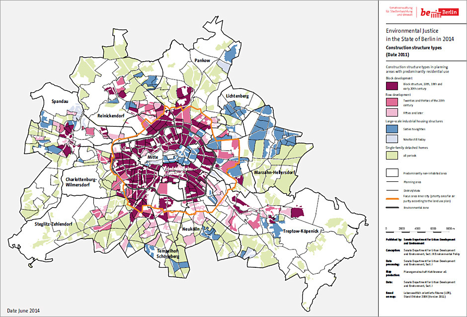
An examination of the areal distribution shows that around half of the Berlin population (47%) has “good/very good” availability, a quarter (25%) has “medium” and a quarter (28%) has “bad/very bad” or “no” availability. Only 5% of the inhabitants with a “good/very good” availability live within, 95% live outside of the Berlin S-Bahn ring. The population with bad, very bad or no availability lives within the S-Bahn ring for the larger part (55%), but a significant part also lives outside (45%), though these planning areas can be assigned to the inner city according to their building structure (Wilhelminian-style block structures).

There is a connection between the PLA availability category and the average block-related population density. In the inner city as well as in the periphery the quality of availability decreases with increasing population density. This means that a dense development tends to reduce the availability of green spaces. However, it should be taken into account that even some planning areas with a higher population density have a good availability of green spaces. Thus, 18 planning areas of the inner city are in the “good” availability category 1 with a population density of 146 inhabitants/ha, while 48 planning areas in the periphery whose population density of 163 inhabitants/ha is just 12% higher are in the “bad” category 3.

The quantitative evaluation for a low social structure index together with bad availability of green spaces yields the following picture: In all, 27 planning areas with around 269,000 inhabitants are situated in this category. They are mostly in the inner city area, with concentrations in the districts of Wedding and Gesundbrunnen and in northern Neukölln. Further towards the periphery, some individual planning areas such as the Thermometer estate (Lichterfelde Süd), the Marzahner Promenade, as well as the Schwarnweberstraße and the Klixstraße (Reinickendorf) are affected. Often, these are planning areas which exhibit further loads (3-, 4- and 5-fold loads).

Core Indicator 4: Bio-Climate/ Thermal Load

(Katzschner, L., Burghardt, R. 2015)

The heat balance of the human organism is closely related to the atmospheric environment. Along with air temperature, wind speed, water vapour pressure and the medium radiation temperature are also relevant. Besides toddlers, whose thermoregulation is still unstable, people with health impairments, such as cardiac and/or circulatory insufficiencies or respiratory disorders, as well as elderly people particularly frequently suffer from health impacts of heat periods. Elderly people sometimes manifest multi-morbid disease patterns, which further reduce their capacity to adapt to heat waves. High-intensity rainfalls, floods and storms have a potential to cause acute injuries and psychological impairments (traumatisation).

In addition, a rise in temperature and extreme weather events also impact indirectly on human health – through a higher risk of microbial (re)contamination of drinking water, the increase of allergenic pollen and infectious diseases.

The climatic situation in Berlin is characterised by the influence of a continental climate with a higher potential for a heavy heat load in the summer months, which is additionally reinforced through the urban heat-island effect. Besides, at times of high-pressure atmospheric conditions in summer, the wind speed values, which on annual average are relatively high, undergo a significant decline of ventilation, so that this effect also reinforces the heating and lack of cooling of the city.

When the urban development plan for climate (Stadtentwicklungsplan Klima, StEP Kilma, SenStadtUm 2011) was developed, the assessment of the bioclimatic situation was based on the dimensionless evaluation index “PMV”. Methodologically, the assessment of the daytime and nighttime situations was carried out differently.

In order to determine the bioclimatic load in terms of the Berlin environmental justice approach, a different evaluation index, the PET, was additionally consulted. The reason lies primarily in the orientation of this evaluation approach, as the environmental medical component enters more strongly into its calculations (cf. Table 2). The values of nighttime cooling were the determining basis for the evaluation.

However, the potential of heat stress during daytime was also taken into consideration, by counting the frequency of summer days with heat load. These were defined as days with a PMV value of at least 1.8, with simultaneous lack of nighttime cooling. Land use information such as the block-related development density formed the basis for the investigation.

The aggregated PET values were determined from these input data and served as a basis for assigning the planning areas to the three levels of bioclimatic load.

Tab. 2: PMV and PET index in comparison

Tab. 2: PMV and PET index in comparison

In order to be able to assess the factor bioclimate according to the Berlin environmental justice approach, the identified PET values had to be aggregated into a three-level scale.

On the basis of the linear assignment of PMV values to PET values as represented in Table 2, a three-level classification was developed in a further step, which focused on a vulnerability assessment of the affected population. For this purpose, the load levels were identified and integrated according to the criteria mentioned:

  • potential for nighttime cooling and
  • possible heat stress during the day.
Tab. 3: Three-level evaluation classification of the thermal index PET

Tab. 3: Three-level evaluation classification of the thermal index PET

The analysis shows that all urban structures with dense development exhibit heat loads which are not sufficiently compensated, not even at nighttime. Half of the planning areas are affected by a high bioclimatic load. 170 planning areas suffer from a medium load and only 49 are load-free. Berlin-wide, altogether 65 planning areas exhibit a high bioclimatic load and a high density of social problems at the same time. In all, 612,000 inhabitants are affected by this. Planning areas which simultaneously have a bad social structure or high problem density as well as a high bioclimatic load are mainly situated in the following districts:

  • Wedding/Gesundbrunnen,
  • Moabit,
  • northern Kreuzberg (Askanischer Platz, Mehringplatz, Moritzplatz),
  • northern Neukölln (e.g. Rollberge, Schillerkiez, Körnerpark, Rixdorf),
  • Spandau (e.g. Paul Hertz estate, Darbystraße, Germersheimer Platz, Kurstraße, Carl-Schurz-Straße),
  • Marzahn-Hellersdorf (e.g. Marzahner Promenade, Wuhletal, Helle Mitte),
  • northern Hohenschönhausen (e.g. eastern and western Falkenberg),
  • Reinickendorf (e.g. Letteplatz, Klixstraße, Scharnweberstraße, Märkisches Zentrum).

Thus, the dense extended inner city, mainly characterised by block structures, and the large estates in both of the former halves of the city are focal points.

Core Indicator 5: Social Problems/ Status-Index

(Gabriel, K. et al. 2015)

Countable events such as mortality and vulnerability to disease strongly depend on class. This has been confirmed by studies in the area of health sociology and public-health research time and again. It is statistically proven that the lower the income, the more premature the mortality. At the same time it is true that the lower the social class, the higher the vulnerability to disease. Problem areas thus exhibit a higher disease risk and correlate negatively with a healthy lifestyle – social stress, malnutrition, lack of leisure options, work conditions with a higher health risk are some of the possible consequences. And yet the causal relations that lie behind this and show a clear causal direction require further investigation.

Consequently, in the framework of the environmental justice conception, it is necessary to include the social differences between the individual neighbourhoods and planning areas in as much detail as possible. The Social Urban Development Monitoring (Monitoring Soziale Stadtentwicklung, MSS) 2013 provides small-scale information concerning the change of socio-structural and socio-spatial development in the 447 planning areas.

The Social Urban Development Monitoring 2013 relies on a set of six status and six dynamic indicators from the field of social reporting, which are used to form aggregated index values because they fulfil the methodological requirement (high intercorrelation) and at the same time describe the facts of social inequality. The index indicators are represented as “status” and as “dynamic indicators“, with the dynamic indicators showing the change of a status indicator over the course of two years. In coordination with the Statistical Office for Berlin-Brandenburg (Amt für Statistik Berlin-Brandenburg, AfS), only the statements about the status index from the Social Urban Development Monitoring 2013 were used for the purpose of compiling the small-scale environmental justice analyses (core and complementary indicators) and for the multiple-load map – the Berlin environmental justice map.

Moreover, with the methodological approach of the environmental justice analysis in mind, as for the other topics the 4-level classification (high, medium, low, very low) used in the Social Urban Development Monitoring 2013 was condensed into a 3-level classification, with the categories “low” and “very low” being merged into one classification. The 3-level classification of the status index of the Berlin environmental justice approach is ordinally described as follows: “high/very high problem density”, “medium problem density” and “low/very low problem density”.

The evaluation shows clear spatial focal points with planning areas with a low/very low social index. These are predominantly districts characterised by Wilhelminian architecture in the former western part of the city. Especially Kreuzberg, Wedding, northern Neukölln as well as the pre-WWII neighbourhoods in the centre of Spandau stand out. A further focal point is formed by the large estates of social or industrial development in both parts of the city. Especially the Märkische Viertel and the Falkenhagener Feld in the west, and Hohenschönhausen, Marzahn and Hellersdorf in the east of the city should be mentioned here. “Smaller” large estates such as Lichtenrade Ost or Lichterfelde Süd are also reflected in the evaluation.

Complementary Indicators

Complementary Indicator 1: Socio-spatial Distribution of the Building Structure

(Planergemeinschaft Kohlbrenner eG 2015)

Taking “healthy living and working conditions” into consideration is a basic principle of the general urban planning laws (§1 (6) clause 1 of the building code (Baugesetzbuch, BauGB 2014)). Even before the building code, the maintenance and creation of healthy living and working conditions was an important guiding principle of urban and architectural planning. The reformist urban development of the early 20th century and the demand for “light, air and sun” in construction are representative of the (demand for) consideration of health aspects in urban development.

However, in the process of Berlin becoming a major city and the concomitant rapid constructional growth, there were different appraisals of the general principles and goals of urban planning and their impact on health and general quality of life. One example of this is the dramatically changing cultural estimation of the Wilhelminian block structure. One reason for this change in attitudes lies in the changing environmental conditions. In recent years, the set of problems has changed significantly due to massive reductions in the field of domestic fuel and industrial air pollution through enhanced technologies and different fuels on the one hand, and due to a significant increase of sound emissions, especially by the motor vehicle traffic, on the other hand. In the process, the assessment of the urban planning situation has undergone changes, as the different structural typologies can damp or reinforce the different loads to different extents. Therefore, the building structures must be included in the assessment of the topics of environmental loads impairing health and their planning area related evaluation.

In order to take the building structure into account, one can draw on the extensive elaboration available in the framework of the Environmental Atlas (cf. 06.07 Urban Structure, SenStadtUm 2011c, and 06.08 Urban Structure – differentiated, SenStadtUm 2011d). Regarding the area types with predominantly residential use, it distinguishes the area types depending on their use, origin as well as building and open space structure. The spatial as well as structure-type differentiation carried out there is here reduced to a few succinct structural types that each exhibit similar characteristics of urban development (cf. Fig. 2):

  • Block-edge development: This category encompasses the Wilhelminian structures as well as the building structures of the interwar period.
  • Row development: This category represents the architectural designs of the interwar and post-war period (multi-storey development in rows, with an open block edge).
  • Large estates: From the 1960s until the 1980s, large multi-storey estates were built in the east and west, which tied in with the traditions of the 1920s and 1930s and claimed to implement the aim of “light, air and sun” to an even greater extent, through differentiated large-scale structures (row, block, point), generous availability of open spaces and adequate positioning of the buildings.

Note: The social differentiation, a partly one-sided occupancy and changed housing demands have in part turned this building type into a social challenge. This impacts on the assessment of the social situation.

  • Open development: Different structural forms of estate and detached house development are combined in this category.

Structural characteristics have a significant impact on the load situation in the different urban spaces, though to some extent with mutually opposing effects of de- or increasing the load (for an overview cf. Table 4).

Tab. 4: Environment-related characteristics of different building structures

Tab. 4: Environment-related characteristics of different building structures

1 primarily Wilhelminian block structure
2 row development, complex housing development, row development and detached housing areas

The point of this representation and integration into the research questions of environmental justice is not to correct the existing assessment of the environmental load topics; the building structure has already been taken into account in their analysis.

Rather, these classifications may serve to quickly match the environmental situation and evaluation with the predominant building structure and to indicate possibilities of urban planning interventions and prioritisations.

Fig. 2: Distribution of the structural types with predominantly residential use at the level of the planning areas

As the structural type “block” is to be viewed rather as an aggravating factor regarding health hazards, the area requires special consideration regarding the interaction of urban structures and health risks and in assessing a possible course of action to influence the situation.

125 planning areas, i.e. roughly 30% of all areas are to be classified into the block-structure type according to the classification applied. Three quarters of these planning areas are in the area inside the S-Bahn ring, i.e. in the environmental zone. This is where the block structure predominates, with few exceptions (Friedrichstadt, Luisenstadt, Tempelhof, areas east of Alexanderplatz). At the same time, the population density is particularly high, also as compared to the block structure outside of the S-Bahn ring. This indicates the differentiation within this structural type.

Complementary Indicator 2: Socio-spatial Distribution of Residential Characters in Berlin

(Planergemeinschaft Kohlbrenner eG 2015)

The different building structures have an aggravating or attenuating impact on health conditions, well-being and the satisfaction with housing. However, the concrete surrounding conditions are also relevant, since in some circumstances building structures of the same kind can differ significantly with respect to housing quality. Therefore, the Berlin rent index not only includes statements related to housing and buildings but also assesses the surroundings of the location of a dwelling along with the residential character. The following characteristics are featured in the differentiation:

  • surrounding use,
  • density,
  • infrastructure,
  • access to public transport,
  • access to recreation areas,
  • demand and image,
  • inner city/suburb.

A high traffic noise load (street, rail, air traffic) is identified as an additional attribute.

Through the residential character, a complex area description is mapped onto a three-level scale, which is supplemented by other descriptive characteristics and can thus contribute to a more differentiated small-scale assessment. The Berlin rent index distinguishes between simple, medium and good residential character.

The information on residential character in the rent index further complements and substantiates the five core indicators and the building structure (cf. Figs. 3 and 4).

Based on the available findings of the Berlin pilot project on environmental justice, the approaches for taking health-relevant factors into account can be further extended and systematised.

Fig. 3: Distribution of the residential characters at the level of the planning areas in Berlin

Fig. 4: Distribution of the simple residential characters at the level of the planning areas in Berlin

As described above, the “simple residential character” exhibits many characteristics problematic for health, such as very dense development, few green and open spaces, predominantly untended cityscape, often bad building condition, and in parts a strong impairment through industry and commerce. Its significance as a complementary indicator becomes evident in evaluating the data.

In December 2010, 42% of the 3.37 million Berlin inhabitants had postal addresses with simple, 41% with medium and 17% with good residential character. At the end of 2010, around 960,000 people (28%) were living at an address with noise load, of whom 46% with simple, 37% with medium and 17% with good residential character.

Complementary Indicator 3: Health and Environmental Risks/ Risk Communication

(SenStadtUm 2015d)

More and more people suffer from health impairments whose cause they see in the environment. In a complex and interlinked world, they have great difficulties in assessing risks to environment and health in their immediate residential surroundings and neighbourhood. The scientific evaluation and the societal perception of health risks from environmental effects can differ, and thus their impact and acceptance are sometimes quite contested in politics, science, economy and the population. Moreover, the criteria according to which experts and the public assess health risks are often very heterogeneous. The reason for this lies in the multitude of different risk and impact factors. This can result in insecurity in the population, and in a loss of trust in the authorities. With a view to the health-oriented environmental justice approach, it is important to render processes of risk assessment transparent and more efficient.

Especially in neighbourhoods with a high multiple load, the persons affected should be enabled to understand the risk circumstances to the extent that they can recognise the consequences and make (individual) assessments. The persons affected should not need any expert knowledge for this purpose, but should rather be enabled to understand the consequences as far as they are known. With a view to making the special risks easily discernible, a map of the complementary indicator “Health and Environmental Risks” has been developed based on the available data (cf. Fig. 5).

In order to indicate the areas with particular health and environmental risks, the planning areas were examined whose core indicators noise load and air pollution – deviating from the employed 3-level classification (good, medium, bad) – exhibit a load clearly above this classification. The noise load and air pollution are especially high in these planning areas, and thus the values are particularly significant from the perspective of environmental medicine. “Simple residential character” according to the rent index (cf. Fig. 4) was chosen as another risk indicator. These are mainly areas in the densely built-up inner-city area, with few green and open spaces, predominantly untended cityscape, often bad building condition, and in some parts strong impairments due to industrial-commercial uses. “Premature mortality from disorders of the respiratory system” was used as a fourth risk indicator related to air pollution (see also the statements regarding complementary indicator 4).

Fig. 5: Distribution of health and environmental risks at the level of the planning areas in Berlin

At the level of the entire city, the evaluation of areas strongly affected (high mortality combined with simple residential character) (more than 66% of the apartments in the PLA affected) in combination with high air pollution and noise load results in the following picture:

  • Out of 447 PLAs, altogether 19 planning areas (PLAs) are affected.
  • Out of these 19 planning areas, 8 PLAs are situated in the “extended inner-city area” (priority area for air purity according to LUP), 11 are outside.
  • Focal points in the inner-city area are: Mitte (Heidestraße, Soldiner Straße, Gesundbrunnen), Friedrichshain-Kreuzberg (Wassertorplatz, Viktoriapark), Tempelhof-Schöneberg (Schöneberger Insel, Germaniagarten) as well as Neukölln (Donaustraße).

Complementary Indicator 4: Environmental Load, Social Disadvantage and Small-scale Mortality in the State of Berlin

(AfS (Statistical Office for Berlin-Brandenburg), Borough Office Mitte of Berlin, Health Department 2015))

The connection between environmental loads, social disadvantage and health impairments, including higher mortality, has been a topic of scientific research in Germany for quite a while.

However, the contexts for the origins of disease and death are usually far too complex and individual to be derived from the more or less large-scale measurements and calculations of the environmental situation. Thus, the approach that in investigating mortality on a small scale it is highest in the planning areas exposed to the heaviest loads – an idea that seems plausible at first – falls short of reality. For information is usually lacking for the further indicators relevant to individual cases, such as

  • exact residential area and duration of residence,
  • working conditions,
  • leisure time behaviour,
  • individual behaviour hazardous to health (e.g. smoking).

Despite these limitations regarding the availability of required additional information, it can be assumed that the criteria

  • age,
  • social condition and
  • the different environmental loads

have a decisive influence on the distribution of deaths and that they can be used for a first planning area related estimation.

In order to determine to what extent the different environmental loads contribute to the (additional) mortality, the analysis particularly needs to consider the “confounding variables” mentioned above, age and social condition. A small-scale analysis of mortality in the State of Berlin in this respect was possible because data regarding mortality, age structure and social condition of the population for the planning areas in the years 2006-2012 are available. In that period, between around 31,000 and a little more than 32,000 people died in Berlin annually. Around 70% of all deaths could be attributed to an underlying disease from the field of tumours (cancer) or diseases of the circulatory or respiratory system.

For the evaluation in this analysis, it was necessary to find a cause for the mortality for which there are a sufficiently many cases as well as a documented connection with environmental loads. Diseases of the respiratory system (e.g. bronchitis, pneumonia, asthma) were chosen for this purpose.

It has been sufficiently proven that the incidence of tumours and circulatory diseases strongly correlates with the social condition of the persons affected. Besides possible environmental loads, the living conditions and the health-relevant behaviour play a major role with respect to mortality. Lung cancer, for example, can be caused both by smoking and through long-term exposure to environmental loads.

The mortality from respiratory diseases also correlates clearly with the status index on the PLA level; however, the possible connection with environmental loads is more obvious in this case than for circulatory diseases, and the potential distortion through confounding variables like lifestyle factors (smoking) is not quite as strong as for lung cancer.

Fig. 6: Distribution of mortality from disorders of the respiratory system 2006-2012 at the level of the planning areas in Berlin

The analyses generated by calculating the correlation between the standardised mortality rate for respiratory diseases and the environmental justice indicators at least indicate a relatively strong linear relationship with the status index (social condition) in the planning areas. Since much information on the individual level is lacking, it is not possible to determine with the data available whether this is due to lifestyle or rather environmental factors. Further investigations on this issue are necessary in order to make reliable statements.

Complementary Indicator 5: Socio-spatial Loads Through Light Pollution

(Gabriel, K. et al. 2015)

Artificial light is also a potential load factor. Artificial light at night disturbs the circadian rhythm of the human organism and results in an imbalance of production of different hormones, especially melatonin, which is related to the human day-night-rhythm. Moreover, interfering with this rhythm can lead to a higher breast and bowel cancer risk, which is particularly relevant for shift workers. As a result, the term light pollution was introduced, which refers to the negative impact of artificial light. On the other hand, light also features as a social component. The illumination of outdoor areas at night is generally perceived as positive; illuminated areas are considered friendlier and safer. This double meaning of artificial light at night leads to the question how nighttime illumination is distributed in Berlin.

In order to obtain an answer to this question, it was necessary to determine a reliable overview over the artificial illumination at night. Contrary to what is common when investigating the brightness of cities, satellite images were not used, but another approach was chosen. Based on a flyover from 2010 which covered two thirds of the city area, a geo-referenced mosaic was generated with a resolution of 1 m² which allowed for an area-wide analysis of the city. It is to be noted that only light emitted skywards was captured. Light radiated sidewards, e.g. from the windows of houses, cannot be captured with this method. With the help of this night shot “Berlin at night”, it was possible to depict the nighttime illumination at the LEA level. In order to implement this, the “brightness factor” was determined, which had originally been used to determine the brightness of individual types of land use (Kuechly 2012). Here the average brightness value of a land-use type is offset against the overall average value of the city; the resulting brightness value yields a good average value for the illumination situation of a land-use type.

The following proportions of light were found for the city:

Tab. 5: Proportion of the brightness value in the overall brightness of the city for different types of land use

Tab. 5: Proportion of the brightness value in the overall brightness of the city for different types of land use

The same principle was then also applied in order to determine the light pollution in the planning areas (PLAs). Following Table 5, the brightness values of the streets were used for determining local brightness, as these contribute the greatest share of the illumination of the city and also have a uniform, direct influence on the houses and the surroundings of the inhabitants. Moreover, this served to avoid a masking effect, as would have occurred when considering the PLA as a whole. The planning area Waldidyll/Flughafensee, in which Tegel airport is situated, affords an illustrative example. In the night shot, it is one of the most obvious points, but when considering the PLA as a whole, the influence of the airport vanishes due to the far larger share of forest area.

Fig. 7: Distribution of the light density at the level of the planning areas in Berlin

Using the 3-level evaluation scale employed for the other factors resulted in a seemingly uniform distribution of light pollution within the city. Apart from the PLA “Unter den Linden Süd”, all other PLAs are at the medium and lower light pollution level. At the same time, there is a general tendency of higher light pollution towards the city centre.

An investigation regarding a connection with residential areas characterised by social issues did not yield a clear result. Thus, pollution with an excessive share of artificial light at night cannot immediately be related to weaker social classes, but rather seems to be a set of problems that affects the entire inner-city area while being less significant in the outskirts of Berlin.