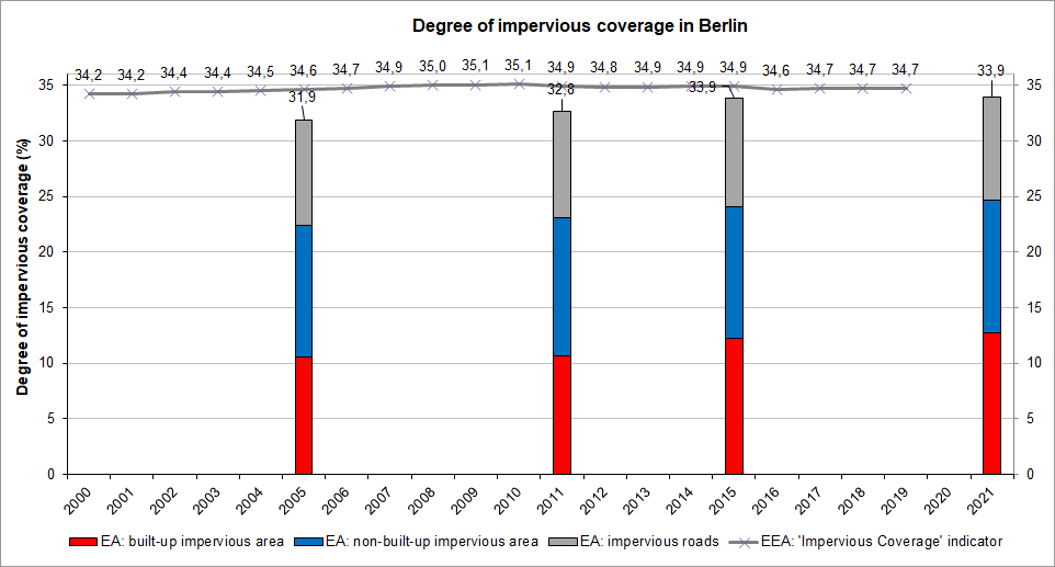
Comparison of the Impervious Coverage Data of 2005, 2011, 2016 and 2021 with the “Impervious Coverage” Indicator of the Environmental Economic Account (EEA) of the German Federal States
In the following, the impervious coverage value of the Environmental Economic Account (EEA) of the German federal states, developed for Berlin by the federal and regional-state soil conservation board (LABO) based on the sustainability indicator “land consumption for residential and traffic areas”, is compared with the results of the Environmental Atlas.
The data collection of the degrees of impervious coverage by federal state is based on the official land statistics. In this process, flat-rate degrees of impervious coverage are assigned to each land use category of residential and traffic areas, which are adjusted to the residential density of the areas, and then used as a factor in calculation. Therefore, impervious coverage data is created for the whole of Germany every year. The data on the development of impervious coverage in the federal states is updated annually ( Statistical Offices of the German States 2021).
According to this, the impervious coverage share of Berlin’s total area rose from 34.24 % to 34.7 % between 2000 and 2019. It thus increased by 0.46 % in 19 years, or by 0.02 % per annum. In 2012, an increased impervious coverage of 35.10 % was recorded, which has been declining slightly since then.
Therefore, the absolute increase in impervious coverage, amounting to approx. 30,912 ha, was 385 ha in nineteen years (Statistical Offices of the German States 2021).
Figure 7 shows the rate of impervious coverage of the Environmental Atlas in 2005, 2011, 2016 and 2021, compared with the annually generated data of the EEA of the German federal states.
Neither approach ascertains impervious coverage with 100% accuracy; both work with different methods and different goals, and, to a certain extent, with estimates and assumptions.
While the EEA approach indicates that the overall impervious coverage of Berlin was 34.7 % in 2019, only 33.9 % of the city were mapped as impervious in the Environmental Atlas in 2021.
For the Environmental Atlas, the built-up impervious area was derived directly from a number of different building stock data sets (in 2005 and 2010 exclusively from ALK, in 2016 and 2021 from ALKIS and NOT-ALKIS building data), and hence has a very high degree of accuracy, while the non-built-up impervious area, as described above, is determined using satellite images. Methodological error sources must be considered as a possibility here.
By contrast, the EEA approach operates from the outset with estimates for the individual use classes, which are also the same nationwide and hence disregard any regional particularities. For instance, the removal of the area of Tempelhof Airport from the category of traffic areas would have changed the statistics, without any actual change in the degree of impervious coverage. When looking at the entire period, there is a trend towards the two values converging.