Morphology of Water Bodies – Overall Assessment (WRRL) 2011

Methodology

Three different methods have been applied to determine the morphological state of the water bodies.

1.) Desktop survey method for rivers and streams (ÜV, LAWA, 2002). The ÜV is based on the interpretation of aerial images as well as current and historic maps, mainly topographic and geological maps. The ÜV provides a broad overview on the morphology of rivers and streams at comparably low cost. However, not all relevant parameters can be derived, especially those characterising the river bed. This method has therefore not been applied in Berlin after 2001.

2.) On site survey method for small rivers and streams (VOV, LAWA, 2000). The VOV is based on information obtained on site. Therefore, it provides a more precise and thorough assessment of the relevant parameters, including those characterising the river bed.

3.) Lake shore survey method (SUK, LUNG, 2004). Similar to the ÜV, the SUK is also based on aerial images and maps (especially topography, geology, bathymetry, habitats). Additionally, all lake shores are observed from a boat in order to allow for the assessment of parameters not easily accessible from aerial images.

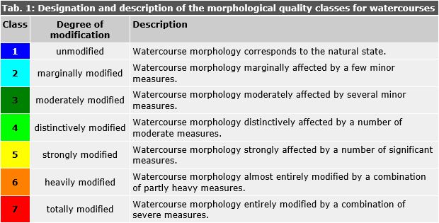
All applied methods classify the morphology of individual river or lake shore segments into seven classes (see Table 1) ranging from "unmodified" (class 1) to "totally modified" (class 7).

Tab. 1: Designation and description of the morphological quality classes for watercourses.

Tab. 1: Designation and description of the morphological quality classes for watercourses.

All three methods (ÜV, VOV, SUK) are based on similar principles: Individual parameters are assessed and then combined to provide an overall assessment of the morphology for individual river or lake shore segments. Further information on the assessment procedure can be obtained from the respective user handbooks (LAWA, 2002; LAWA, 2000; LUNG, 2004).

Assessment of the Methodology

The methods applied to determine the morphological state of water bodies are relatively new and do not yet consider all conditions naturally occurring in the various landscapes in Germany. This may lead to "unjust" assessments.

For example, the on-site survey method for watercourses (LAWA, 2000) does not always properly account for the typical conditions encountered in the North German lowlands, especially as regards the river beds. This may lead to overly negative assessment of certain river bed parameters and in consequence to an incorrect assessment of the overall morphology. Based on more than ten years of operational experience, the on site survey method for watercourses has been recently fully revised, offering an improved differentiation between the morphological types of watercourses naturally occurring in Germany (LANUV, 2012).

Similarly, it is intended to also revise and harmonise the various existing methods for mapping the lake shore morphology in order to achieve a "fairer" assessment for the wide range of morphological lake shore structures encountered in Germany as well as to provide a better interface with biological surveys.

Despite their deficiencies, the methods applied to determine the morphology of water bodies already allow for a meaningful identification of watercourse or lake shore segments with problematic morphology and therefore constitute a very valuable source of information for management and planning purposes.