Between 2001 and 2013, 64 mapping projects were carried out to gather primary data.
The digital data were processed with the especially developed YADE GIS© specialised application BTK. Here, the data of the mapping projects are imported, the complete map is prepared, and the results are evaluated and audited. The mapping data based on surface surveying and aerial images, the so-called primary data, have substantive priority, and are combind with the secondary data to produce the full-coverage biotope type map.
The material stipulated to be used as the base for the mapping are the Map of Berlin, 1: 5000 (K5) and/or the ALK. It is recommended that current ortho-aerial photos be used for better delimitation of the areas. For biotope type mapping in forest areas, the geometries of the Basic Forestry Map must be adopted (sub-divisible). The surface biotope mappings were produced in scales of 1000 to 5000, depending on function and area size; the aerial image mappings were carried out for output scales of 3000 or 5000.
At a mapping scale of 2000 to 5000, the minimum size of biotopes which can be shown two-dimensionally is 500 to 1000 sq. m. Areas narrower than 10 m are shown as linear biotopes. The minimum length of a linear biotope is 30 to 50 m. Biotopes below the indicated minimum sizes are as a rule shown as points. If they are of conservation relevance, these minimum sizes/lengths may also be subsceded in particular cases.
Biotope mappings are carried out in the terrain on work maps prepared from the base maps with at least the scale of the mapping process. For all factual data gathered, a mapping list is maintained, in which the main biotope, and if appropriate, accompanying and additional biotopes, are entered, together with the reference to the work map (recording number).
For especially protected and other biotopes valuable for conservation, such as forest biotopes, a terrain sheet is filled out containing the following further-reaching information about the biotope:
- Name of biotope type
- Description of biotope type
- Identification of the sub-types
- Distinctive vegetation/mapping indicators (delimitation criteria)
- Distinctive plant species
- Fauna
- Value defining parameters for fauna
- Common/typical species
- Lead species
- Target species
- Species groups to be examined
- Mapping instructions
- Information on endangerment and protected status
- Instructions on other mapping keys
- Instructions regarding the Habitats Directive.
If a biotope cannot be described exclusively by one biotope type, additional and accompanying biotope types may be assigned. “Additional biotopes” are defined as biotope types additionally possible throughout the area of the main biotope, e.g. uses. “Accompanying biotopes” are associated biotopes which cannot be mapped due to their small scale; they do not exist throughout the spatial extent of the main biotope, e.g. wooded islands in a cane brake.
Access to the desired biotope class (01 -12) is accomplished first of all by assignment to more or less easily delimitable habitat types (e.g., streams, standing waters, bogs, woodlands etc.). Within these biotope classes, the biotope groups are structured according to certain characteristics (e.g., streams, lakes), according to the manner of their creation (e.g. artificial waters), or according to rough plant-community units (mostly classes or associations). The particular biotope types and their sub-units are delimited from each other in the same manner, according to plant-sociological aspects, or to certain forms of anthropogenic use.
In some cases, the assignment of biotope types according to plant sociological criteria is prefered over other criteria. Thus for example, the alder, pine and birch bog woods, which, on the basis of habitat type might more likely be assigned to the Bogs and marshes class, are here rather assigned to Forests (08), due to their plant-sociological association.
In biotope classes 10 through 12 (anthropogenic biotopes, special biotopes, residential areas, etc.), plant-sociological criteria understandably play hardly any role at all. Here, the structure is therefore oriented largely towards the manner of use, and phaenological characteristics. Numerous complex biotope types, e.g. inland dunes, osers, and dry valleys, have been incorporated into the Special Biotopes class (11). For detailed mapping, the breakdown into single biotope types of other classes is possible here, but due to their mostly well-developed structuring, it is not always appropriate.
If a biotope cannot be assigned to a certain grouping, or in case of richly structured biotope complexes, the assignment to a group (e.g. 0512 = Dry meadow) is sufficient. In the mapping key, a short description of the biotope class (e.g. 01 Streams) is generally followed by a description of the biotope groups (e.g. 01100 Springs and spring swamps, 01110 Creeks and small rivers, etc.).
The biotope groups are further subdivided into biotope types, acording to particular characteristics. Generally, a description, particulars on vegetation, on characteristic plant species, on the fauna, and on endangerment and protection are provided for the biotope groups. If the vegetation has diagnostic value for some biotope types (e.g. 051 Moist meadows, with the sub-groups 05101 through 05106), the information on every single biotope type is specified. The indicated distinctive plant species need not exist in all assessment areas; they serve merely as a supporting indicator for the classification of the biotopes mapped. Many plant species can be found more or less regularly in various biotopes. These species include not only the actual characteristic or identifying species of the plant communities occurring in the biotopes in question, but also common ancillary species.
The assignment of a legal protected status as per §30 Federal Conservation Law and §28 Berlin Conservation Law is carried out on the basis of the technical assessment of the mapper. The probable protected status is usually indicated via aerial image biotope type mapping (provided there is no surface investigation). The decision on the application of the stipulation “Legally protected biotopes” in particular cases is provided by the responsible subordinate conservation authorities of the boroughs. In the map 05.08.2 “Biotope types – legally protected biotopes” areas with unclear or not yet indicated status by the responsible subordinate conservation authorities are marked with the symbol §? (F=areas, L= lines, P= points). These are areas where the mapper supposed a legal status (because of e.g.cane brakes) but because of damages or untypical occurences a clear indication by airborne photos was not possible. These damages can be a high degree of neophytes,
waste or depletion. In these cases the user should understand that an actual legally protected biotope do not have the necessary quality for a legally protected biotope at the moment.
To ascertain the mapping methodology and data quality, please also use the data source in the factual data.
The habitat type or complex under the Habitats Directive is determined exclusively by the terrain mapper. This indicates whether the biotope corresponds to a Natura 2000 habitat type or is part of a complex of habitat types (“LRT complex”). Biotopes are considered part of an LRT complex if they either correspond to the definitions of the habitat type as per the Habitats Directive manual, but in the assessment under the ABC scheme receive a lower classification in at least one category (so-called “degenerate” or D-areas) or have the potential for development to a habitat type, an LRT (a so-called “development” or E-areas); or if they are listed in the Habitats Directive manual as forming a close ecological complex with such an LRT (so-called complex or biotope association areas).
An example of the procedure of mapping via aerial images is documented here.
Biotope Values
The evaluation and assessment of biotopes is important for the evaluation and auditing of interventions in nature and the landscape and the associated planning process, as per §14 of the Berlin Conservation of Nature Law. The Procedure for the Evaluation and Auditing of Impacts in Nature and the Landscape in the state of Berlin has been developed in order to provide the responsible authorities, especially at the borough level, with a uniform basis for assessment.
All biotopes mapped in Berlin have been subjected to a uniform evaluation process under this procedure, as represented in the Biotope Values Map (05.08.5). The purpose of this map is to use biotope values in order to demonstrate the conflict potentials of interventions in nature and the landscape.
Biotope values are ascertained according to a differentiated point-count process. Details of this method are explained in the guideline.
The total point count of a biotope value consists of the sum of the base and risk values. The base value consists of the value criteria: hemeroby (“naturalness”), occurrence of endangered species, rarity/endangerment of the biotope, and diversity of plant and animal species. The risk value is derived from the length of time needed to re-create the community of species, and the recreatability of the abiotic site conditions.
The specific point values of all biotopes evaluated are available in a biotope list.
For representation in the map, the total point count (biotope value) ascertained for each biotope type was broken down into eight biotope value classes. Here, a biotope value (BW) of 0 corresponds to BW Class 1, i.e. a small conflict potential; the scale goes up to BW Class 8, with an extremely high conflict potential. The eight biotope value classes are not shown in colour on the map, but rather are differentiated by the shading, according to primary and secondary data.
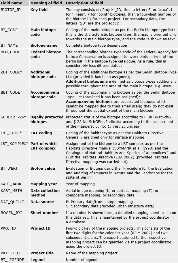
Factual data
All maps from the Berlin Biotope Type Mapping Project include uniform factual data.
The following factual data exist for all areas, lines and points shown on the map (the fields marked with * contain data only in the primary data base):
The data survey method employed is noted for every data set, in the data field “Methodology”.