Potential for the Removal of Impervious Soil Coverage (Soil De-Sealing) 2023

Methodology

The procedure was based on a multistage concept, including a combination of research and compilation of information from local experts, and an evaluation based on available geo-data of the State of Berlin.

In the context of the pilot phase of the project “Potential for the Removal of Impervious Coverage in Berlin”, an example was examined. The aim was to determine the extent to which a purely automated area search, based on the extensive geo-data of the State of Berlin, could yield suitable results by intersecting the data and applying filters. Despite extensive trials, the generated results were unsuitable for further use. It was decided to continue with the survey process using local experts, and to refine the process.

Investigation of Areas

Since 2010, the borough offices of the Berlin boroughs have been conducting reserach. Whenever possible, representatives of the borough offices responsible for urban planning, landscape planning, green spaces and environment and conservation were included in the process. First, those boroughs with a high proportion of sites characteristic of the outskirts of the city were investigated. The survey confirmed the assumption that these boroughs contained the greatest potential for the removal of impervious coverage.

Moreover, the survey was carried out at the four Berlin forestry agencies (Grunewald, Köpenick, Pankow, and Tegel). During this investigation 41 areas were recorded that are located outside Berlin borders.

Also, public and private land owners of large properties which, from their portfolios, seemed to be likely to have suitable properties in their inventories, were contacted in writing.

It should be noted here that it is optional for borough authorities, Berlin forestry agencies etc. to record and share information on potential areas that may have their impervious cover removed. The reports are based on expert assessments, nonbinding and may also be withdrawn if changes in spatial or sectoral planning occur.

The aim of the survey was to identify such areas which are permanently no longer required for construction use and for which the planned urban development does not prevent the permanent removal of their impervious covers in the foreseeable future. The local, planning and other information needed for this could primarily be obtained from the interviewees in the urban and/ or landscape planning authorities in the boroughs. The aim of this investigation did not include, however, the preparation of finalised plans for impervious coverage removal measures. Any remaining need for clarification or agreement was noted in the data compiled on the areas.

Ascertainment of Factual Data

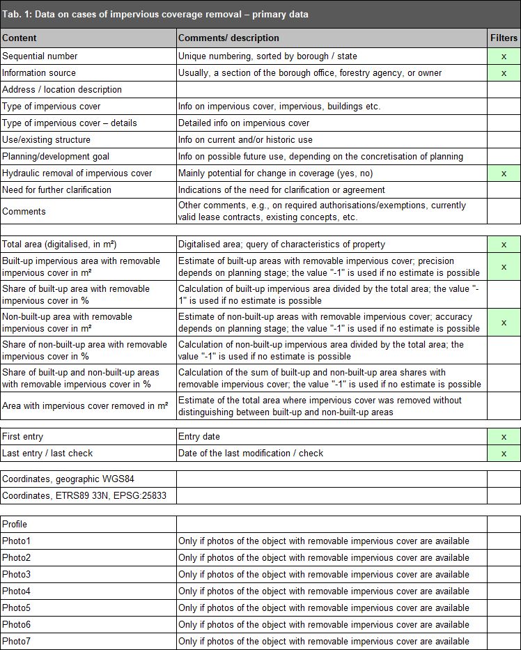
A variety of information was compiled for each potential area that may have its impervious cover removed. This information was used to help assess the suitability for such removal measures as well as for further planning purposes (cf. Tab. 1). This involved primarily information on:

  • the location of areas (borough, neighbourhood, address/location description, coordinates),
  • the property situation, and contact data if applicable,
  • current (or former) use,
  • planned use or changes in use, and
  • type of impervious cover, and extent of its possible removal.

Additional, non-specific information could also be entered in the comment box.

In order to permit a more precise assessment of the extent and cost of possible impervious coverage removal measures, about two thirds of the areas contained in the database have additionally been photographically documented to date. A selection of these photos is linked in the factual data on the respective areas.

It is generally possible that soil pollution is an issue in the areas that have been identified. With regard to further handling, a case-by-case decision is made by the responsible soil protection authority. For this purpose, data is compared with the soil pollution record (BKK) of the State of Berlin. If necessary, the partial removal of an impervious cover is also an option.

Intersection with Land Referenced Data

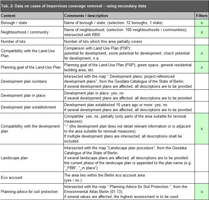
The data obtained was intersected with the extensive available digital land referenced data available in the State of Berlin. Information on current or concluded development planning and landscape planning procedures, the Land-Use Plan, as well as information from the maps, and the map “Planning Advice for Soil Protection” were therefore linked to potential areas suitable for the removal of their impervious cover. As a result, this information is available at a glance (cf. Tab. 2).

Prioritisation

Moreover, there are four criteria which are meant to guide the prioritisation of potential areas for the removal of impervious coverage:

  • property rights,
  • expert assessment,
  • technical effort, and
  • time required for implementation.

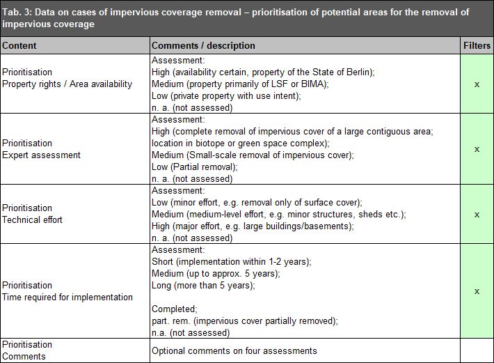
For each case, this prioritisation is carried out using a three-point scale. If a case cannot be evaluated, “n. a.” is entered. Additional comments may be entered in the comment box linked to the evaluation as needed (cf. Tab. 3).
In the evaluation of property rights/ area availability, areas, which are the property of the State of Berlin, or which can generally be considered available for other reasons (e.g. if an agreement with the private owner has already been reached) are classified as “high”. Areas which are predominantly the property of the Berlin Properties Fund (LSF), or, to the extent that is known, can be attributed to the Institute for Federal Real Estate (BIMA), or some other federal agency (e.g. the Federal Waterways) fall into the “medium” category. Areas with an unkown property situation, i.e. generally areas either in private ownership or federal assets, are classified as “low”.

Areas are classified as “high” in the expert assessment, if their impervious covers may be removed completely, and if the resulting open space connects to other green and open spaces that are already in place or being planned. Areas receive a “medium” rating if they do not contain large, contiguous areas suitable for removal measures. They are rather characterised by large areas suitable for partial removal measures or scattered areas suitable for a complete removal. Finally, areas suitable for small-scale isolated measures, or a very limited partial removal only, are classified as “low”. The expert assessment also considers information on the hydraulic removal of impervious coverage. It refers to previously (fully) impervious areas that have received a new type of cover that is permeable to water and air, as these areas often still play a role in development (paths, courtyards, parking spaces, etc.). The idea here is to improve the infiltration of precipitation. The size of the area suitable for removal measures cannot usually be precisely quantified in square metres. It must be determined on site on a case by case basis. The possibility of changing the type of cover for partial areas may also be explored here.

The ascertainment of the technical effort depends on the type of impervious cover, or the degree of development of the area. A large need for building demolition or a large proportion of multistorey buildings, which may have basements, thus implies a high level of effort. A simple removal of impervious covers, such as that of pathway or roadways, constitutes a low level of effort. Between the two are demolition measures of a medium level of effort, involving the removal not only of the cover itself, but also of small structures, such as cottages, garages or other special structural facilities, such as greenhouses.

In order to assess the implementation timeframe, a rough estimate of the necessary planning effort/ preliminary work was carried out. The implementation timeframe was then categorised as short-term (1 to 2 years), medium-term (up to approx. 5 years), or long-term (more than 5 years).

Implementation

After the removal of an impervious cover has been completed, the area is retained in the register, and marked on the map using a distinct type of hatching. The same process is applied to areas after a partial removal. Moreover, information on the measures carried out, the contact persons, etc. may be recorded in the data table (cf. Tab. 4).

Tabular Overview of the Data

The following overview presents each field of the data table with a brief description, distinguishing the following categories:

  • primary data,
  • data obtained by intersection or manual comparison with geo-data existing in the State of Berlin,
  • data fields containing evaluations of the areas, and
  • data fields containing information on the completed implementation of measures for removing impervious covers.

The data may be accessed via the map in the Geoportal/ FIS-Broker for each individual area, or may be displayed as a separate data table. It is also possible to filter the data records by some of the data fields to display a customised selection of areas. The following tables therefore also indicate (green, x) whether a data field supports the filter function.

Tab. 1: Data on cases of impervious coverage removal – primary data

Tab. 1: Data on cases of impervious coverage removal – primary data

Tab. 2: Data on cases of impervious coverage removal – using secondary data

Tab. 2: Data on cases of impervious coverage removal – using secondary data

Tab. 3: Data on cases of impervious coverage removal – prioritisation of potential areas for the removal of impervious coverage

Tab. 3: Data on cases of impervious coverage removal – prioritisation of potential areas for the removal of impervious coverage

Tab. 4: Data on cases of impervious coverage removal – implementing removal measures

Tab. 4: Data on cases of impervious coverage removal – implementing removal measures